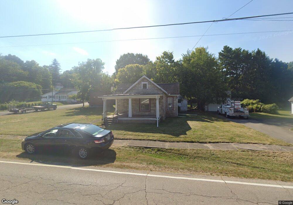
207 N Mulberry St Tremont City, OH 45372
Estimated Value: $82,000 - $111,050
2
Beds
1
Bath
956
Sq Ft
$101/Sq Ft
Est. Value
About This Home
This home is located at 207 N Mulberry St, Tremont City, OH 45372 and is currently estimated at $97,017, approximately $101 per square foot. 207 N Mulberry St is a home located in Clark County with nearby schools including Northwestern Elementary School, Northwestern Junior/Senior High School, and Ridgewood School.
Ownership History
Date
Name
Owned For
Owner Type
Purchase Details
Closed on
Jun 18, 2012
Sold by
Lay Kathryn L
Bought by
Baumer Joseph
Current Estimated Value
Purchase Details
Closed on
Aug 27, 2008
Sold by
Lay Martha O and Lay Marty
Bought by
Lay Kathryn L
Purchase Details
Closed on
Aug 7, 2008
Sold by
Estate Of Paul Raymond Lay
Bought by
Lay Martha O
Purchase Details
Closed on
Aug 31, 2007
Sold by
Lay Marty
Bought by
Lay Kathryn L
Purchase Details
Closed on
Oct 1, 1985
Sold by
Haddix Mary Ainsworth
Bought by
Lay Paul R and Lay Marty O
Create a Home Valuation Report for This Property
The Home Valuation Report is an in-depth analysis detailing your home's value as well as a comparison with similar homes in the area
Home Values in the Area
Average Home Value in this Area
Purchase History
| Date | Buyer | Sale Price | Title Company |
|---|---|---|---|
| Baumer Joseph | $18,300 | Ohio Real Estate Title | |
| Lay Kathryn L | -- | Attorney | |
| Lay Martha O | -- | None Available | |
| Lay Kathryn L | -- | None Available | |
| Lay Paul R | $3,800 | -- |
Source: Public Records
Tax History Compared to Growth
Tax History
| Year | Tax Paid | Tax Assessment Tax Assessment Total Assessment is a certain percentage of the fair market value that is determined by local assessors to be the total taxable value of land and additions on the property. | Land | Improvement |
|---|---|---|---|---|
| 2024 | $84 | $1,910 | $1,430 | $480 |
| 2023 | $84 | $1,910 | $1,430 | $480 |
| 2022 | $87 | $1,910 | $1,430 | $480 |
| 2021 | $80 | $1,580 | $1,180 | $400 |
| 2020 | $79 | $1,580 | $1,180 | $400 |
| 2019 | $80 | $1,580 | $1,180 | $400 |
| 2018 | $78 | $1,530 | $1,180 | $350 |
| 2017 | $78 | $1,530 | $1,180 | $350 |
| 2016 | $153 | $3,070 | $1,180 | $1,890 |
| 2015 | $27 | $2,979 | $1,180 | $1,799 |
| 2014 | $54 | $2,979 | $1,180 | $1,799 |
| 2013 | $27 | $2,979 | $1,180 | $1,799 |
Source: Public Records
Map
Nearby Homes
- 30 Center St
- 6250 Willowdale Rd
- 4211 Grey Stone Crossing
- 4328 Pine Tree Place
- 3802 Lawrenceville Dr
- 593 Hiser Ave
- 4100 Troy Rd Unit 96
- 4100 Troy Rd Unit 12
- 5646 Springfield-Urbana Pike Unit Lot 88
- 5646 Springfield-Urbana Pike Unit Lot 122
- 5646 Springfield-Urbana Pike Unit Lot 61
- 5646 Springfield-Urbana Pike Unit Lot 127
- 5646 Springfield-Urbana Pike Unit Lot 72
- 794 Donnelly Ave
- 4514 Dowden St
- 880 Brendle Trace Unit 28
- 26 Thomaston Trail
- 916 Sawmill Ct
- 970 Forest Edge Ave
- 214 N Mulberry St
- 204 N Mulberry St
- 14 Church Hill Rd
- 221 N Mulberry St
- 123 N Mulberry St
- 13 Church Hill Rd
- 220 N Mulberry St
- 115 N Mulberry St
- 226 N Mulberry St
- 118 N Mulberry St
- 118 N Mulberry St
- 18 North St
- 230 N Mulberry St
- 27 Church Hill Rd
- 107 N Mulberry St
- 115 High St
- 108 N Mulberry St
- 103 N Mulberry St
- 24 North St
- 28 Church Hill Rd