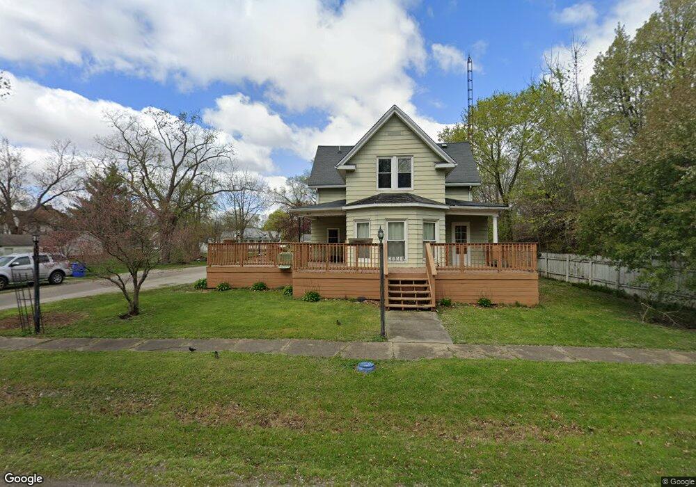
207 S Main St Middletown, IL 62666
Estimated Value: $90,501 - $112,000
3
Beds
2
Baths
1,692
Sq Ft
$58/Sq Ft
Est. Value
About This Home
This home is located at 207 S Main St, Middletown, IL 62666 and is currently estimated at $97,875, approximately $57 per square foot. 207 S Main St is a home located in Logan County with nearby schools including New Holland-Middletown Elementary School and Lincoln Community High School.
Ownership History
Date
Name
Owned For
Owner Type
Purchase Details
Closed on
May 31, 2024
Sold by
Steffens Ryan J
Bought by
Richards Cory
Current Estimated Value
Home Financials for this Owner
Home Financials are based on the most recent Mortgage that was taken out on this home.
Original Mortgage
$93,939
Outstanding Balance
$92,846
Interest Rate
7.5%
Mortgage Type
New Conventional
Estimated Equity
$5,029
Purchase Details
Closed on
Jun 8, 2020
Sold by
Stout Jennifer M
Bought by
Steffens Ryan J
Home Financials for this Owner
Home Financials are based on the most recent Mortgage that was taken out on this home.
Original Mortgage
$65,786
Interest Rate
3.2%
Mortgage Type
FHA
Purchase Details
Closed on
Mar 2, 1994
Sold by
Stout Harold and Stout Jennifer
Bought by
Stout Harold S and Stout Jennifer M
Create a Home Valuation Report for This Property
The Home Valuation Report is an in-depth analysis detailing your home's value as well as a comparison with similar homes in the area
Purchase History
| Date | Buyer | Sale Price | Title Company |
|---|---|---|---|
| Richards Cory | $93,000 | None Available | |
| Steffens Ryan J | $67,000 | None Available | |
| Stout Harold S | $22,500 | -- |
Source: Public Records
Mortgage History
| Date | Status | Borrower | Loan Amount |
|---|---|---|---|
| Open | Richards Cory | $93,939 | |
| Previous Owner | Steffens Ryan J | $65,786 |
Source: Public Records
Tax History
| Year | Tax Paid | Tax Assessment Tax Assessment Total Assessment is a certain percentage of the fair market value that is determined by local assessors to be the total taxable value of land and additions on the property. | Land | Improvement |
|---|---|---|---|---|
| 2024 | $1,133 | $19,640 | $2,200 | $17,440 |
| 2023 | $1,014 | $18,100 | $2,030 | $16,070 |
| 2022 | $933 | $16,870 | $1,890 | $14,980 |
| 2021 | $870 | $16,220 | $1,820 | $14,400 |
| 2020 | $416 | $15,980 | $1,790 | $14,190 |
| 2019 | $396 | $15,740 | $1,760 | $13,980 |
| 2018 | $401 | $15,740 | $1,760 | $13,980 |
| 2017 | $636 | $18,460 | $2,060 | $16,400 |
| 2016 | $465 | $18,480 | $2,060 | $16,420 |
| 2015 | $289 | $16,140 | $1,800 | $14,340 |
| 2014 | $289 | $16,140 | $1,800 | $14,340 |
| 2013 | $289 | $15,230 | $1,700 | $13,530 |
| 2012 | $289 | $15,180 | $1,690 | $13,490 |
Source: Public Records
Map
Nearby Homes
- 300 N Clinton St
- 101 S Anson St
- 31651 West Ave
- 169 1550th St
- 403 W Delavan St
- 1736 600th Ave
- 13 Chicory Dr
- 14 Chicory Dr
- 11-12 Chicory Dr
- 0 Blue Stem Dr
- 23340 State Highway 29
- 100 Governor Oglesby St
- 445 S Cleveland St
- 405 S Gillett St
- 101 W Oak St
- 308 Ward Dr
- 10312 N Co Road 3850e
- 3 Governor's Dr
- 124 E Prairie St
- 10 Governors Dr
Your Personal Tour Guide
Ask me questions while you tour the home.