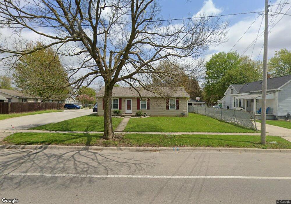
207 S Mckenzie St Adrian, MI 49221
Estimated Value: $142,000 - $182,000
3
Beds
1
Bath
1,008
Sq Ft
$162/Sq Ft
Est. Value
About This Home
This home is located at 207 S Mckenzie St, Adrian, MI 49221 and is currently estimated at $163,621, approximately $162 per square foot. 207 S Mckenzie St is a home located in Lenawee County with nearby schools including Adrian High School, Berean Baptist Academy, and Trenton Hills Learning Center.
Ownership History
Date
Name
Owned For
Owner Type
Purchase Details
Closed on
Mar 5, 2021
Sold by
Raper James D
Bought by
Rogers Douglas P and Rogers Brenda C
Current Estimated Value
Home Financials for this Owner
Home Financials are based on the most recent Mortgage that was taken out on this home.
Original Mortgage
$92,000
Outstanding Balance
$82,748
Interest Rate
2.9%
Mortgage Type
Purchase Money Mortgage
Estimated Equity
$80,873
Purchase Details
Closed on
Nov 13, 2019
Sold by
Raper James D
Bought by
Raper James D
Create a Home Valuation Report for This Property
The Home Valuation Report is an in-depth analysis detailing your home's value as well as a comparison with similar homes in the area
Home Values in the Area
Average Home Value in this Area
Purchase History
| Date | Buyer | Sale Price | Title Company |
|---|---|---|---|
| Rogers Douglas P | $115,000 | None Available | |
| Raper James D | -- | -- |
Source: Public Records
Mortgage History
| Date | Status | Borrower | Loan Amount |
|---|---|---|---|
| Open | Rogers Douglas P | $92,000 |
Source: Public Records
Tax History
| Year | Tax Paid | Tax Assessment Tax Assessment Total Assessment is a certain percentage of the fair market value that is determined by local assessors to be the total taxable value of land and additions on the property. | Land | Improvement |
|---|---|---|---|---|
| 2025 | $3,967 | $69,600 | $0 | $0 |
| 2024 | $30 | $65,200 | $0 | $0 |
| 2023 | $3,774 | $60,100 | $0 | $0 |
| 2022 | $3,169 | $56,000 | $0 | $0 |
| 2021 | $2,508 | $51,500 | $0 | $0 |
| 2020 | $2,492 | $47,900 | $0 | $0 |
| 2019 | $1,776 | $45,500 | $0 | $0 |
| 2018 | $113,664 | $52,943 | $0 | $0 |
| 2017 | $1,650 | $40,626 | $0 | $0 |
| 2016 | $1,635 | $37,593 | $0 | $0 |
| 2014 | -- | $33,000 | $0 | $0 |
Source: Public Records
Map
Nearby Homes
- 778 College Ave
- 313 Rice St
- 705 College Ave
- 404 S Mckenzie St
- 169 Park St
- 143 Park St
- 965 W Maumee St Unit A
- 967 W Maumee St Unit A
- 914 W Maumee St
- 155 S Scott St
- 959 W Maumee St Unit B
- 140 Greenly St
- 1136 Michigan Ave
- 218 Greenly St
- 227 Greenly St
- 228 W Church St
- 333 Greenly St
- 349 Greenly St
- 1062 Oram Dr
- 306 Summer St
- 225 S Mckenzie St
- 215 S Mckenzie St
- 779 College Ave
- 231 S Mckenzie St
- 773 College Ave
- 218 S Mckenzie St
- 765 College Ave
- 237 S Mckenzie St
- 759 College Ave
- 809 College Ave
- 805 College Ave
- 770 Michigan Ave
- 236 S Mckenzie St
- 766 Michigan Ave
- 224 S Mckenzie St
- 753 College Ave
- 778 Michigan Ave
- 230 S Mckenzie St
- 817 College Ave
- 760 Michigan Ave
Your Personal Tour Guide
Ask me questions while you tour the home.