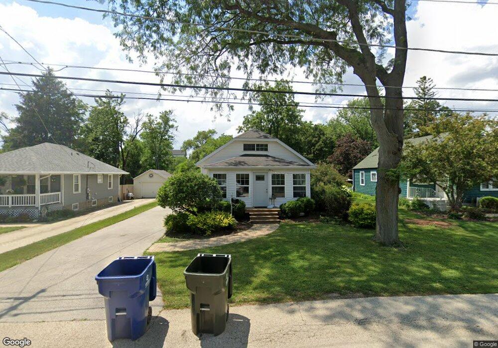
207 S Pine St New Lenox, IL 60451
Estimated Value: $191,000 - $329,000
Studio
--
Bath
--
Sq Ft
9,583
Sq Ft
About This Home
This home is located at 207 S Pine St, New Lenox, IL 60451 and is currently estimated at $272,921. 207 S Pine St is a home located in Will County with nearby schools including Bentley Elementary School, Arnold J Tyler School, and Alex M Martino Jr High School.
Ownership History
Date
Name
Owned For
Owner Type
Purchase Details
Closed on
Aug 2, 2024
Sold by
Schalmo Lori A and Bartels Lori A
Bought by
Lori A Bartels Trust and Bartels
Current Estimated Value
Purchase Details
Closed on
Sep 30, 1998
Sold by
Stephens Stella and Becker Linda S
Bought by
Schalmo Lori A
Home Financials for this Owner
Home Financials are based on the most recent Mortgage that was taken out on this home.
Original Mortgage
$101,750
Interest Rate
6.5%
Create a Home Valuation Report for This Property
The Home Valuation Report is an in-depth analysis detailing your home's value as well as a comparison with similar homes in the area
Home Values in the Area
Average Home Value in this Area
Purchase History
| Date | Buyer | Sale Price | Title Company |
|---|---|---|---|
| Lori A Bartels Trust | -- | None Listed On Document | |
| Schalmo Lori A | $110,500 | -- |
Source: Public Records
Mortgage History
| Date | Status | Borrower | Loan Amount |
|---|---|---|---|
| Previous Owner | Schalmo Lori A | $101,750 |
Source: Public Records
Tax History
| Year | Tax Paid | Tax Assessment Tax Assessment Total Assessment is a certain percentage of the fair market value that is determined by local assessors to be the total taxable value of land and additions on the property. | Land | Improvement |
|---|---|---|---|---|
| 2024 | $6,528 | $80,444 | $22,770 | $57,674 |
| 2023 | $6,528 | $73,331 | $20,757 | $52,574 |
| 2022 | $6,308 | $67,555 | $19,122 | $48,433 |
| 2021 | $5,568 | $63,534 | $17,984 | $45,550 |
| 2020 | $5,462 | $61,267 | $17,342 | $43,925 |
| 2019 | $5,199 | $59,367 | $16,804 | $42,563 |
| 2018 | $5,090 | $57,320 | $16,225 | $41,095 |
| 2017 | $4,846 | $55,673 | $15,759 | $39,914 |
| 2016 | $4,712 | $54,183 | $15,337 | $38,846 |
| 2015 | $4,549 | $52,477 | $14,854 | $37,623 |
| 2014 | $4,549 | $51,830 | $14,671 | $37,159 |
| 2013 | $4,549 | $52,529 | $14,869 | $37,660 |
Source: Public Records
Map
Nearby Homes
- 289 Osage Ln
- 1787 Lakes Park Dr
- 3126 Timberlake Ave
- 3000 Timberlake Ave
- 3003 Timberlake Ave
- 2930 Amaranth Ct
- 270 Osage Ln
- 250 Teerling Cir
- 1777 Lakes Park Dr
- 2951 Amaranth Ct
- 2920 Amaranth Ct
- 3174 Waterwood Ln
- 2940 Amaranth Ct
- 295 Osage Ln
- 3114 Timberlake Ave
- 3198 Waterwood Ln
- 238 Teerling Cir
- 3132 Timberlake Ave
- 1701 Lakes Park Dr
- 202 Shadbush Ct
Your Personal Tour Guide
Ask me questions while you tour the home.