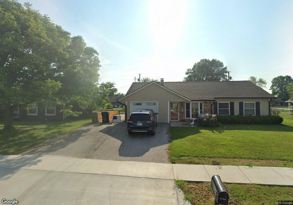
207 W 600 N Whiteland, IN 46184
Estimated Value: $262,000 - $286,870
3
Beds
2
Baths
1,508
Sq Ft
$179/Sq Ft
Est. Value
About This Home
This home is located at 207 W 600 N, Whiteland, IN 46184 and is currently estimated at $269,968, approximately $179 per square foot. 207 W 600 N is a home with nearby schools including Break-O-Day Elementary School, Clark-Pleasant Middle School, and Whiteland Community High School.
Ownership History
Date
Name
Owned For
Owner Type
Purchase Details
Closed on
Sep 24, 2021
Sold by
Habitat For Humanity Of Johnson County I
Bought by
Trefry Kylie A
Current Estimated Value
Home Financials for this Owner
Home Financials are based on the most recent Mortgage that was taken out on this home.
Original Mortgage
$60,575
Outstanding Balance
$55,239
Interest Rate
2.8%
Mortgage Type
New Conventional
Estimated Equity
$214,729
Purchase Details
Closed on
Dec 3, 2019
Sold by
New Whiteland Town
Bought by
Habitat For Humanity Of Johnson County I
Create a Home Valuation Report for This Property
The Home Valuation Report is an in-depth analysis detailing your home's value as well as a comparison with similar homes in the area
Home Values in the Area
Average Home Value in this Area
Purchase History
| Date | Buyer | Sale Price | Title Company |
|---|---|---|---|
| Trefry Kylie A | $240,000 | None Available | |
| Habitat For Humanity Of Johnson County I | -- | None Available |
Source: Public Records
Mortgage History
| Date | Status | Borrower | Loan Amount |
|---|---|---|---|
| Open | Trefry Kylie A | $60,575 | |
| Open | Trefry Kylie A | $181,596 |
Source: Public Records
Tax History Compared to Growth
Tax History
| Year | Tax Paid | Tax Assessment Tax Assessment Total Assessment is a certain percentage of the fair market value that is determined by local assessors to be the total taxable value of land and additions on the property. | Land | Improvement |
|---|---|---|---|---|
| 2025 | $2,474 | $301,700 | $27,000 | $274,700 |
| 2024 | $2,474 | $236,900 | $27,000 | $209,900 |
| 2023 | $2,411 | $231,700 | $27,000 | $204,700 |
| 2022 | $2,354 | $226,300 | $21,600 | $204,700 |
| 2021 | $0 | $19,500 | $19,500 | $0 |
| 2020 | $0 | $19,500 | $19,500 | $0 |
| 2019 | $0 | $0 | $0 | $0 |
| 2018 | $0 | $0 | $0 | $0 |
| 2017 | $10 | $0 | $0 | $0 |
| 2016 | -- | $0 | $0 | $0 |
| 2014 | -- | $0 | $0 | $0 |
| 2013 | -- | $0 | $0 | $0 |
Source: Public Records
Map
Nearby Homes
- 106 Tracy Ridge Blvd
- 143 Tracy Ridge Blvd
- 821 Princeton Dr
- 1119 Chateaugay Ct
- 12 Rypma Row
- 190 Tracy Ridge Blvd
- 256 Bittersweet Dr
- 731 W 600 N
- 250 Southlane Dr
- 647 Bluestem Cir
- 0 E 700 N Unit MBR22036500
- 840 Sweetbriar Ave
- 239 Shelton Place
- Liberty Plan at Crossroads at Southport
- 7331 Deerberg Dr
- Jefferson Plan at Crossroads at Southport
- 7338 Deerberg Dr
- Rushmore Plan at Crossroads at Southport
- Lincoln Plan at Crossroads at Southport
- Washington Plan at Crossroads at Southport
- 203 W 600 N
- 188 Arabian Ct
- 251 W 600 N
- 180 Arabian Ct
- 139 Arabian Ct Unit B
- 131 Arabian Ct
- 131 Arabian Ct Unit A
- 164 Arabian Ct
- 6010 N 25 W
- 903 Nicole Way
- 901 Nicole Way
- 905 Nicole Way
- 156 Arabian Ct
- 123 Arabian Ct
- 907 Nicole Way
- 909 Nicole Way
- 148 Arabian Ct
- 115 Arabian Ct
- 115 Arabian Ct Unit A
- 911 Nicole Way