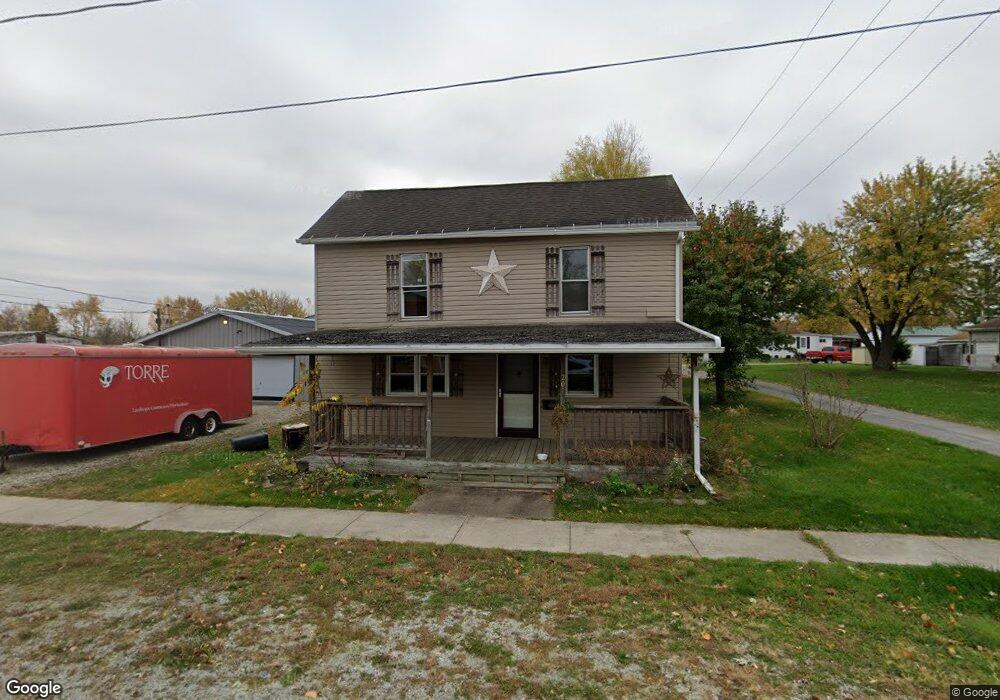
207 W High St Cridersville, OH 45806
Estimated Value: $27,658 - $184,000
3
Beds
1
Bath
1,540
Sq Ft
$56/Sq Ft
Est. Value
About This Home
This home is located at 207 W High St, Cridersville, OH 45806 and is currently estimated at $86,915, approximately $56 per square foot. 207 W High St is a home located in Auglaize County with nearby schools including Cridersville Elementary School, Wapakoneta High School, and Wapakoneta Middle School.
Ownership History
Date
Name
Owned For
Owner Type
Purchase Details
Closed on
Jul 24, 2025
Sold by
Mcelroy Neil Allen and Johnson Adam D
Bought by
Valenti Frank J
Current Estimated Value
Purchase Details
Closed on
Jul 7, 2003
Sold by
Bowersock Deanna L
Bought by
Mcelroy Neil A
Purchase Details
Closed on
Jan 5, 1995
Sold by
Bowersock Millard L
Bought by
Bowersock Deanna L
Purchase Details
Closed on
Jul 2, 1993
Sold by
Law Scott Andrew
Bought by
Law Scott Andrew
Purchase Details
Closed on
May 1, 1989
Create a Home Valuation Report for This Property
The Home Valuation Report is an in-depth analysis detailing your home's value as well as a comparison with similar homes in the area
Home Values in the Area
Average Home Value in this Area
Purchase History
| Date | Buyer | Sale Price | Title Company |
|---|---|---|---|
| Valenti Frank J | $27,500 | None Listed On Document | |
| Valenti Frank J | $27,500 | None Listed On Document | |
| Mcelroy Neil A | $37,000 | -- | |
| Bowersock Deanna L | -- | -- | |
| Law Scott Andrew | $35,000 | -- | |
| -- | $20,000 | -- |
Source: Public Records
Tax History Compared to Growth
Tax History
| Year | Tax Paid | Tax Assessment Tax Assessment Total Assessment is a certain percentage of the fair market value that is determined by local assessors to be the total taxable value of land and additions on the property. | Land | Improvement |
|---|---|---|---|---|
| 2024 | $1,648 | $31,250 | $5,510 | $25,740 |
| 2023 | $1,125 | $31,250 | $5,510 | $25,740 |
| 2022 | $990 | $24,790 | $5,100 | $19,690 |
| 2021 | $970 | $24,790 | $5,100 | $19,690 |
| 2020 | $497 | $24,787 | $5,096 | $19,691 |
| 2019 | $837 | $20,829 | $4,284 | $16,545 |
| 2018 | $842 | $20,829 | $4,284 | $16,545 |
| 2017 | $838 | $20,829 | $4,284 | $16,545 |
| 2016 | $638 | $15,775 | $4,081 | $11,694 |
| 2015 | $983 | $15,775 | $4,081 | $11,694 |
| 2014 | $644 | $15,775 | $4,081 | $11,694 |
| 2013 | $655 | $15,775 | $4,081 | $11,694 |
Source: Public Records
Map
Nearby Homes
- 310 W Main St
- 212 S Oak St
- 5290 New Haven Dr
- 1835 Huntington Dr
- 1805 Huntington Dr
- 2638 Summer Rambo Ct
- 2648 Summer Rambo Ct
- 2613 Jonathon Dr
- 2691 Jonathan Dr
- 17946 National Rd
- 137 Caribou Cir
- 1934 Jo Jean Rd
- 18609 County Road 25a
- 3780 Shawnee Rd
- 3744 Linfield Ln
- 301 Muskingum Trail
- 1643 W Breese Rd Unit 73
- 2517 Hall Dr
- 3549 Camden Place
- 3375 Weldon Dr