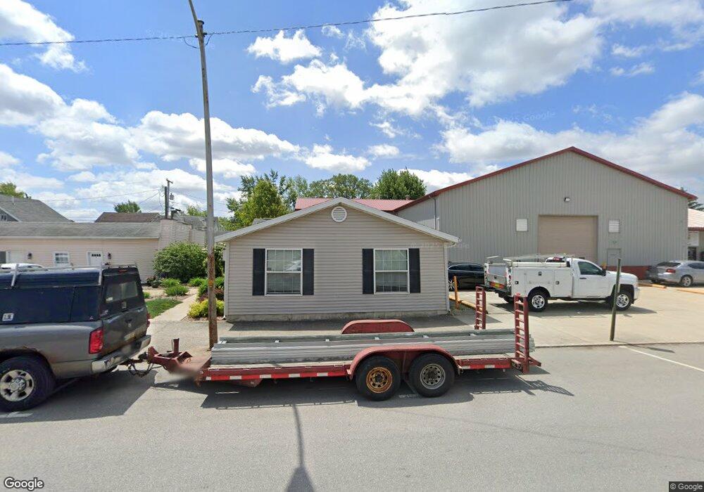
207 W Perry St Paulding, OH 45879
Estimated Value: $105,928 - $115,000
2
Beds
2
Baths
1,152
Sq Ft
$97/Sq Ft
Est. Value
About This Home
This home is located at 207 W Perry St, Paulding, OH 45879 and is currently estimated at $111,309, approximately $96 per square foot. 207 W Perry St is a home with nearby schools including Paulding High School.
Ownership History
Date
Name
Owned For
Owner Type
Purchase Details
Closed on
Dec 7, 2016
Sold by
Griffiths Alan W
Bought by
Dovetail Development Ltd
Current Estimated Value
Purchase Details
Closed on
Sep 6, 2012
Sold by
Griffiths Alan W and Griffiths Cheri L
Bought by
Griffths Alan W
Purchase Details
Closed on
Jun 29, 2005
Sold by
Cook Todd Kenton and Cook Rebecca S
Bought by
Griffiths Alan W and Griffiths Cheri L
Purchase Details
Closed on
Nov 19, 1997
Sold by
Bates Lee R
Bought by
Griffiths Alan W Trustee
Create a Home Valuation Report for This Property
The Home Valuation Report is an in-depth analysis detailing your home's value as well as a comparison with similar homes in the area
Home Values in the Area
Average Home Value in this Area
Purchase History
| Date | Buyer | Sale Price | Title Company |
|---|---|---|---|
| Dovetail Development Ltd | -- | None Available | |
| Griffths Alan W | -- | None Available | |
| Griffiths Alan W | $28,500 | None Available | |
| Griffiths Alan W Trustee | $25,200 | -- |
Source: Public Records
Tax History
| Year | Tax Paid | Tax Assessment Tax Assessment Total Assessment is a certain percentage of the fair market value that is determined by local assessors to be the total taxable value of land and additions on the property. | Land | Improvement |
|---|---|---|---|---|
| 2025 | $1,185 | $26,850 | $1,540 | $25,310 |
| 2024 | $1,185 | $21,840 | $1,260 | $20,580 |
| 2023 | $1,001 | $21,840 | $1,260 | $20,580 |
| 2022 | $973 | $21,840 | $1,260 | $20,580 |
| 2021 | $838 | $16,770 | $1,120 | $15,650 |
| 2020 | $753 | $16,770 | $1,120 | $15,650 |
| 2019 | $759 | $15,330 | $1,120 | $14,210 |
| 2018 | $707 | $15,330 | $1,120 | $14,210 |
| 2017 | $725 | $15,330 | $1,120 | $14,210 |
| 2016 | $708 | $15,330 | $1,120 | $14,210 |
| 2015 | $748 | $16,450 | $1,400 | $15,050 |
| 2014 | $745 | $16,450 | $1,400 | $15,050 |
| 2013 | $807 | $16,450 | $1,400 | $15,050 |
Source: Public Records
Map
Nearby Homes
- 214 W Perry St
- 000 E Perry St
- 201 W Perry St
- 108 S Cherry St
- 114 S Cherry St
- 216 W Harrison St
- 220 W Harrison St
- 220 W Harrison St
- 122 S Cherry St
- 120 S Walnut St
- 118 W Perry St
- 221 W Jackson St Unit AB
- 315 W Perry St
- 310 W Perry St
- 215 W Harrison St
- 221 W Harrison St
- 209 W Harrison St
- 314 W Harrison St
- 321 W Perry St
- 202 S Cherry St
Your Personal Tour Guide
Ask me questions while you tour the home.