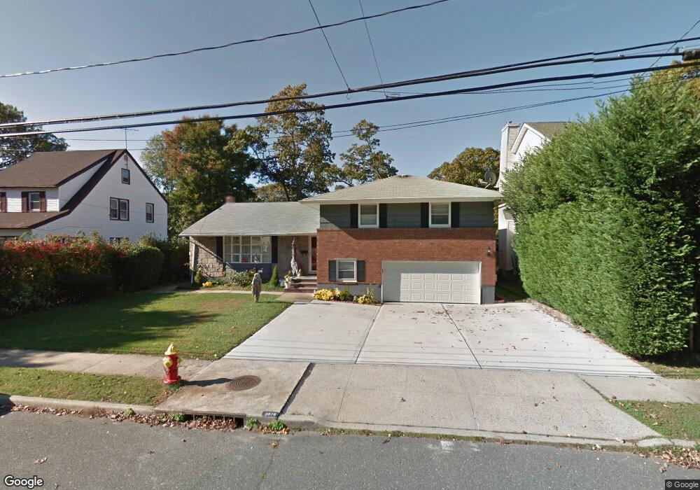
2070 Sherman St Merrick, NY 11566
Estimated Value: $907,592 - $1,083,000
--
Bed
3
Baths
2,003
Sq Ft
$497/Sq Ft
Est. Value
About This Home
This home is located at 2070 Sherman St, Merrick, NY 11566 and is currently estimated at $995,296, approximately $496 per square foot. 2070 Sherman St is a home located in Nassau County with nearby schools including Merrick Avenue Middle School, Sanford H Calhoun High School, and Grace Christian Academy.
Ownership History
Date
Name
Owned For
Owner Type
Purchase Details
Closed on
Jun 10, 2010
Sold by
Radianu Andrei and Radianu Valentina
Bought by
Radianu Andrei
Current Estimated Value
Purchase Details
Closed on
Feb 25, 2005
Sold by
Cole Richard J
Bought by
Huda Subrul
Purchase Details
Closed on
Feb 27, 2003
Sold by
Shaw Warren
Purchase Details
Closed on
Aug 9, 2002
Sold by
Hekel William J
Bought by
Cole Richard
Purchase Details
Closed on
Jun 19, 2002
Sold by
Hekel Family Trust
Bought by
Ada Development Corp
Purchase Details
Closed on
Jun 4, 2002
Sold by
Marzigliano Thomas
Bought by
Shaw Warren
Create a Home Valuation Report for This Property
The Home Valuation Report is an in-depth analysis detailing your home's value as well as a comparison with similar homes in the area
Home Values in the Area
Average Home Value in this Area
Purchase History
| Date | Buyer | Sale Price | Title Company |
|---|---|---|---|
| Radianu Andrei | -- | -- | |
| Huda Subrul | $615,500 | -- | |
| -- | $37,000 | -- | |
| Cole Richard | $390,000 | -- | |
| Ada Development Corp | $150,000 | -- | |
| Shaw Warren | $350,000 | -- |
Source: Public Records
Tax History Compared to Growth
Tax History
| Year | Tax Paid | Tax Assessment Tax Assessment Total Assessment is a certain percentage of the fair market value that is determined by local assessors to be the total taxable value of land and additions on the property. | Land | Improvement |
|---|---|---|---|---|
| 2025 | $17,817 | $623 | $248 | $375 |
| 2024 | $4,303 | $623 | $248 | $375 |
| 2023 | $15,505 | $623 | $248 | $375 |
| 2022 | $15,505 | $623 | $248 | $375 |
| 2021 | $20,504 | $598 | $211 | $387 |
| 2020 | $13,926 | $915 | $380 | $535 |
| 2019 | $15,921 | $915 | $374 | $541 |
| 2018 | $14,863 | $930 | $0 | $0 |
| 2017 | $9,275 | $930 | $380 | $550 |
| 2016 | $13,255 | $930 | $380 | $550 |
| 2015 | $3,691 | $930 | $380 | $550 |
| 2014 | $3,691 | $930 | $380 | $550 |
| 2013 | $3,492 | $930 | $380 | $550 |
Source: Public Records
Map
Nearby Homes
- 96 Thelma Ave
- 1931 Miller Place
- 1818 Gormley Ave
- 179 Commonwealth Ave
- 1729 Gormley Ave
- 1922 Horatio Ave
- 25 Babylon Turnpike
- 1707 Carroll Ave
- 1938 Meadowbrook Rd
- 138 Hewlett Ave
- 2291 Girard Place
- 2991 Girard Place
- 1824 Gildersleeve St
- 1741 Pettit Ave
- 1690 Argyle Rd
- 2 Garfield St
- 1772 Rose St
- 42 E Webster St
- 1910 Adair Place
- 131 Gregory Ave
- 20 Sherman St
- 37 Sherman St
- 2067 Washington St
- 122 Washington St
- 33 Sherman St
- 45 Sherman St
- 2073 Washington St
- 126 Washington St
- 38 Sherman St
- 44 Sherman St
- 36 Sherman St
- 1 Washington
- 2079 Washington St
- 2079 Washington St
- 2054 Sherman St
- 32 Sherman St
- 2059 Sherman St
- 29 Sherman St
- 2083 Washington St
- 2049 Washington St