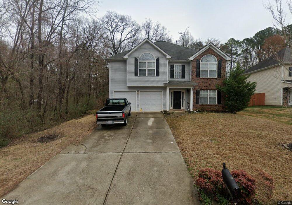
2071 Covered Bridge Ct Unit 95 Rock Hill, SC 29732
Estimated Value: $447,002
4
Beds
3
Baths
2,604
Sq Ft
$172/Sq Ft
Est. Value
About This Home
This home is located at 2071 Covered Bridge Ct Unit 95, Rock Hill, SC 29732 and is currently estimated at $447,002, approximately $171 per square foot. 2071 Covered Bridge Ct Unit 95 is a home located in York County with nearby schools including Mount Gallant Elementary School, Dutchman Creek Middle School, and Northwestern High School.
Ownership History
Date
Name
Owned For
Owner Type
Purchase Details
Closed on
Mar 30, 2022
Sold by
Walker Wendy W
Bought by
Wegley John Paul
Current Estimated Value
Home Financials for this Owner
Home Financials are based on the most recent Mortgage that was taken out on this home.
Original Mortgage
$392,000
Outstanding Balance
$368,866
Interest Rate
4.42%
Mortgage Type
VA
Estimated Equity
$78,136
Purchase Details
Closed on
Mar 14, 2020
Sold by
Cordway Sean T
Bought by
Walker Wendy W
Purchase Details
Closed on
Feb 28, 2007
Sold by
Crestwood Homes Llc
Bought by
Cordway Sean T
Purchase Details
Closed on
May 8, 2006
Sold by
Mag Land Development Llc
Bought by
Crestwood Homes Llc
Create a Home Valuation Report for This Property
The Home Valuation Report is an in-depth analysis detailing your home's value as well as a comparison with similar homes in the area
Home Values in the Area
Average Home Value in this Area
Purchase History
| Date | Buyer | Sale Price | Title Company |
|---|---|---|---|
| Wegley John Paul | $392,000 | None Listed On Document | |
| Walker Wendy W | $145,000 | None Available | |
| Cordway Sean T | $206,033 | None Available | |
| Crestwood Homes Llc | $1,260,000 | None Available |
Source: Public Records
Mortgage History
| Date | Status | Borrower | Loan Amount |
|---|---|---|---|
| Open | Wegley John Paul | $392,000 |
Source: Public Records
Tax History Compared to Growth
Tax History
| Year | Tax Paid | Tax Assessment Tax Assessment Total Assessment is a certain percentage of the fair market value that is determined by local assessors to be the total taxable value of land and additions on the property. | Land | Improvement |
|---|---|---|---|---|
| 2024 | $2,114 | $15,088 | $1,600 | $13,488 |
| 2023 | $8,300 | $22,621 | $2,400 | $20,221 |
| 2022 | $1,398 | $9,698 | $1,600 | $8,098 |
| 2021 | -- | $9,698 | $1,600 | $8,098 |
| 2020 | $1,129 | $7,843 | $0 | $0 |
| 2019 | $3,541 | $10,230 | $0 | $0 |
| 2018 | $3,470 | $10,230 | $0 | $0 |
| 2017 | $3,321 | $10,230 | $0 | $0 |
| 2016 | $3,232 | $10,230 | $0 | $0 |
| 2014 | $899 | $6,820 | $1,400 | $5,420 |
| 2013 | $899 | $7,060 | $1,460 | $5,600 |
Source: Public Records
Map
Nearby Homes
- 2060 Covered Bridge Ct
- 2035 Covered Bridge Ct
- 2028 Covered Bridge Ct
- 516 Cool Creek Dr
- 2019 Covered Bridge Ct Unit 107
- 233 Tributary Dr
- 305 White Water Dr
- 675 Winding Branch Rd
- 1767 Hands Mill Hwy
- 885 Regulus Ct
- 885 Regulus Ct Unit 42
- 881 Regulus Ct Unit 43
- 877 Regulus Ct Unit 44
- 725 Sirius Ln
- 725 Sirius Ln Unit 90
- 733 Sirius Ln
- 745 Sirius Ln Unit 95
- 626 Amberjack Place
- 626 Amberjack Place Unit 79
- 638 Amberjack Place Unit 76
- 2071 Covered Bridge Ct
- 2075 Covered Bridge Ct
- 2063 Covered Bridge Ct
- 2079 Covered Bridge Ct
- 2059 Covered Bridge Ct
- 2072 Covered Bridge Ct
- 2076 Covered Bridge Ct
- 2083 Covered Bridge Ct
- 2055 Covered Bridge Ct
- 00 Old Eury Rd
- 2080 Covered Bridge Ct
- 2056 Covered Bridge Ct
- 2056 Covered Bridge Ct Unit 80
- 2087 Covered Bridge Ct
- 2051 Covered Bridge Ct
- 2052 Covered Bridge Ct
- 2084 Covered Bridge Ct
- 1826 Allison Cir
- 2091 Covered Bridge Ct
- 2091 Covered Bridge Ct Unit 90