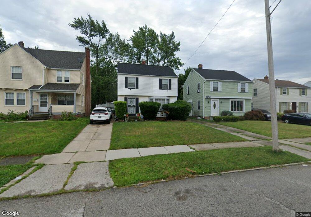
20718 Clare Ave Maple Heights, OH 44137
Estimated Value: $101,000 - $125,000
3
Beds
1
Bath
1,135
Sq Ft
$98/Sq Ft
Est. Value
About This Home
This home is located at 20718 Clare Ave, Maple Heights, OH 44137 and is currently estimated at $111,218, approximately $97 per square foot. 20718 Clare Ave is a home located in Cuyahoga County with nearby schools including Abraham Lincoln Elementary School, Rockside/ J.F. Kennedy School, and Italy High School.
Ownership History
Date
Name
Owned For
Owner Type
Purchase Details
Closed on
Feb 22, 2012
Sold by
Estate Of Thomas R Alford
Bought by
Alford Hazel
Current Estimated Value
Purchase Details
Closed on
May 12, 1994
Sold by
Perry Mark L
Bought by
Secretary Of H.U.D
Purchase Details
Closed on
Aug 24, 1987
Sold by
Bernett Joseph A
Bought by
Perry Mark L
Purchase Details
Closed on
Mar 26, 1985
Sold by
Bernett Joseph and Bernett Carol V
Bought by
Bernett Joseph A
Purchase Details
Closed on
Jan 1, 1975
Bought by
Bernett Joseph and Bernett Carol
Create a Home Valuation Report for This Property
The Home Valuation Report is an in-depth analysis detailing your home's value as well as a comparison with similar homes in the area
Home Values in the Area
Average Home Value in this Area
Purchase History
| Date | Buyer | Sale Price | Title Company |
|---|---|---|---|
| Alford Hazel | -- | None Available | |
| Secretary Of H.U.D | -- | -- | |
| Perry Mark L | $53,500 | -- | |
| Bernett Joseph A | -- | -- | |
| Bernett Joseph | -- | -- |
Source: Public Records
Tax History Compared to Growth
Tax History
| Year | Tax Paid | Tax Assessment Tax Assessment Total Assessment is a certain percentage of the fair market value that is determined by local assessors to be the total taxable value of land and additions on the property. | Land | Improvement |
|---|---|---|---|---|
| 2024 | $2,123 | $33,145 | $6,720 | $26,425 |
| 2023 | $1,574 | $23,800 | $4,060 | $19,740 |
| 2022 | $1,606 | $23,800 | $4,060 | $19,740 |
| 2021 | $1,712 | $23,800 | $4,060 | $19,740 |
| 2020 | $1,238 | $18,030 | $3,080 | $14,950 |
| 2019 | $1,227 | $51,500 | $8,800 | $42,700 |
| 2018 | $1,209 | $18,030 | $3,080 | $14,950 |
| 2017 | $1,197 | $17,640 | $2,870 | $14,770 |
| 2016 | $1,155 | $17,640 | $2,870 | $14,770 |
| 2015 | $3,325 | $17,640 | $2,870 | $14,770 |
| 2014 | $3,325 | $19,390 | $3,150 | $16,240 |
Source: Public Records
Map
Nearby Homes
- 20814 Kenyon Dr
- 20701 Kenyon Dr
- 20510 Mountville Dr
- 21102 Raymond St
- 20107 Libby Rd
- 21207 Franklin Rd
- 20814 Watson Rd
- 21416 Gardenview Dr
- 20715 Watson Rd
- 20907 Watson Rd
- 19807 Gardenview Dr
- 19806 Mountville Dr
- 19812 Stockton Ave
- 20120 Mccracken Rd
- 19520 Maple Heights Blvd
- 19289 Stafford Ave
- 20625 Centuryway Rd
- 20750 Bowling Green Rd
- 5165 Camden Rd
- 20732 Applegate Rd
- 20800 Clare Ave
- 20714 Clare Ave
- 20806 Clare Ave
- 20710 Clare Ave
- 20808 Clare Ave
- 20719 Gardenview Dr
- 20706 Clare Ave
- 20715 Gardenview Dr
- 20803 Gardenview Dr
- 20711 Gardenview Dr
- 20814 Clare Ave
- 20702 Clare Ave
- 20807 Gardenview Dr
- 20719 Clare Ave
- 20707 Gardenview Dr
- 20803 Clare Ave
- 20715 Clare Ave
- 20807 Clare Ave
- 20711 Clare Ave
- 20818 Clare Ave