Estimated Value: $83,350 - $137,000
2
Beds
1
Bath
792
Sq Ft
$133/Sq Ft
Est. Value
About This Home
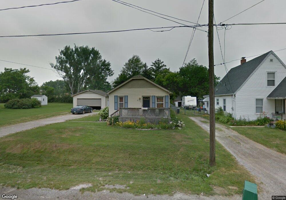
This home is located at 2072 Anoka St, Flint, MI 48532 and is currently estimated at $105,588, approximately $133 per square foot. 2072 Anoka St is a home located in Genesee County with nearby schools including Carman-Ainsworth High School, Genesee STEM Academy, and St. Paul Lutheran School.
Ownership History
Date
Name
Owned For
Owner Type
Purchase Details
Closed on
Apr 1, 2018
Sold by
Korea Victor
Bought by
Walker Ladelvin
Current Estimated Value
Purchase Details
Closed on
Feb 15, 2017
Sold by
Dover Julianne
Bought by
Korea Victor
Purchase Details
Closed on
Jun 3, 2005
Sold by
Nelson Charles L
Bought by
Dover Julianne
Purchase Details
Closed on
Feb 16, 2001
Sold by
Fisk Halleen T
Bought by
Nelson Charles L
Create a Home Valuation Report for This Property
The Home Valuation Report is an in-depth analysis detailing your home's value as well as a comparison with similar homes in the area
Home Values in the Area
Average Home Value in this Area
Purchase History
| Date | Buyer | Sale Price | Title Company |
|---|---|---|---|
| Walker Ladelvin | -- | None Available | |
| Korea Victor | $25,601 | None Available | |
| Dover Julianne | $91,000 | Guaranty Title Company | |
| Nelson Charles L | -- | -- |
Source: Public Records
Mortgage History
| Date | Status | Borrower | Loan Amount |
|---|---|---|---|
| Closed | Walker Ladelvin | $0 |
Source: Public Records
Tax History
| Year | Tax Paid | Tax Assessment Tax Assessment Total Assessment is a certain percentage of the fair market value that is determined by local assessors to be the total taxable value of land and additions on the property. | Land | Improvement |
|---|---|---|---|---|
| 2025 | $1,424 | $40,000 | $0 | $0 |
| 2024 | $860 | $35,500 | $0 | $0 |
| 2023 | $812 | $29,100 | $0 | $0 |
| 2022 | $507 | $26,500 | $0 | $0 |
| 2021 | $497 | $24,700 | $0 | $0 |
| 2020 | $734 | $20,900 | $0 | $0 |
| 2019 | $725 | $18,000 | $0 | $0 |
| 2018 | $1,361 | $20,300 | $0 | $0 |
| 2017 | $1,841 | $20,300 | $0 | $0 |
| 2016 | $1,641 | $18,800 | $0 | $0 |
| 2015 | $708 | $18,300 | $0 | $0 |
| 2014 | $420 | $17,600 | $0 | $0 |
| 2012 | -- | $20,800 | $20,800 | $0 |
Source: Public Records
Map
Nearby Homes
- 2033 Eberly Rd
- 18.41 Taft Rd
- 1512 Crescent Lane Dr Lot#46
- 10 Acres T A Mansour Blvd
- 4199 Sheraton Dr
- 4474 Corunna Rd
- 4480 Corunna Rd
- 1455 S Linden Rd
- 0 Charter Dr Unit 50153638
- 3277 Whitney Ave
- 3365 Ridgecliffe Dr
- 3.9 Acres W Court St
- VL Clairmont St
- 2521 White Oak Place
- 2 Charter Dr
- 4335 Lennon Rd
- 1137 S Graham Rd
- 3493 Ridgecliffe Dr
- 3320 Timberview St
- 000 Devenish Ln
Your Personal Tour Guide
Ask me questions while you tour the home.