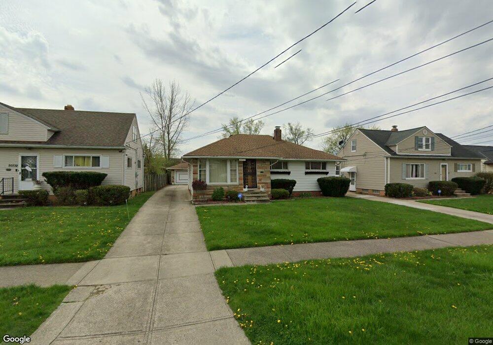
20728 Donny Brook Rd Maple Heights, OH 44137
Estimated Value: $131,000 - $135,000
3
Beds
1
Bath
1,160
Sq Ft
$115/Sq Ft
Est. Value
About This Home
This home is located at 20728 Donny Brook Rd, Maple Heights, OH 44137 and is currently estimated at $133,585, approximately $115 per square foot. 20728 Donny Brook Rd is a home located in Cuyahoga County with nearby schools including Abraham Lincoln Elementary School, Rockside/ J.F. Kennedy School, and Barack Obama School.
Ownership History
Date
Name
Owned For
Owner Type
Purchase Details
Closed on
Jun 25, 1990
Sold by
Franklin Otis
Bought by
Franklin Otis
Current Estimated Value
Purchase Details
Closed on
Nov 6, 1989
Sold by
Pat Sciara
Bought by
Franklin Otis
Purchase Details
Closed on
Nov 14, 1978
Sold by
Sciara Pat and Sciara Frances
Bought by
Pat Sciara
Purchase Details
Closed on
Jan 1, 1975
Bought by
Sciara Pat and Sciara Frances
Create a Home Valuation Report for This Property
The Home Valuation Report is an in-depth analysis detailing your home's value as well as a comparison with similar homes in the area
Home Values in the Area
Average Home Value in this Area
Purchase History
| Date | Buyer | Sale Price | Title Company |
|---|---|---|---|
| Franklin Otis | -- | -- | |
| Franklin Otis | $70,000 | -- | |
| Pat Sciara | -- | -- | |
| Sciara Pat | -- | -- |
Source: Public Records
Tax History
| Year | Tax Paid | Tax Assessment Tax Assessment Total Assessment is a certain percentage of the fair market value that is determined by local assessors to be the total taxable value of land and additions on the property. | Land | Improvement |
|---|---|---|---|---|
| 2024 | $2,601 | $38,605 | $8,575 | $30,030 |
| 2023 | $1,550 | $23,100 | $5,670 | $17,430 |
| 2022 | $1,583 | $23,100 | $5,670 | $17,430 |
| 2021 | $1,683 | $23,100 | $5,670 | $17,430 |
| 2020 | $1,222 | $17,500 | $4,310 | $13,200 |
| 2019 | $1,208 | $50,000 | $12,300 | $37,700 |
| 2018 | $1,474 | $17,500 | $4,310 | $13,200 |
| 2017 | $1,219 | $17,500 | $4,270 | $13,230 |
| 2016 | $1,808 | $23,560 | $4,270 | $19,290 |
| 2015 | $1,911 | $23,560 | $4,270 | $19,290 |
| 2014 | $1,911 | $25,900 | $4,690 | $21,210 |
Source: Public Records
Map
Nearby Homes
- 123 Willard Ave
- 54 Willard Ave
- 66 Hubbell Way
- 58 Hubbell Way
- 62 Hubbell Way
- 54 Hubbell Way
- 0 Hubbell Cir
- 61 Hubbell Way
- 57 Hubbell Way
- 339 Grand Blvd
- 5424 Fairtree Rd
- 419 Center Rd
- 21607 Libby Rd
- 21202 Gardenview Dr
- 19113 Watercrest Ave
- 109 Avalon Dr
- 20806 Clare Ave
- 541 Helper Dr
- 21202 Hillgrove Ave
- 5385 Bartlett Rd
- 20724 Donny Brook Rd
- 20732 Donny Brook Rd
- 20720 Donny Brook Rd
- 20736 Donny Brook Rd
- 20716 Donny Brook Rd
- 20740 Donny Brook Rd
- 20712 Donny Brook Rd
- 20731 Donnybrook Rd
- 20744 Donny Brook Rd
- 20723 Donny Brook Rd
- 20727 Donny Brook Rd
- 20708 Donny Brook Rd
- 20719 Donny Brook Rd
- 20731 Donny Brook Rd
- 20735 Donny Brook Rd
- 20715 Donny Brook Rd
- 20748 Donny Brook Rd
- 20704 Donny Brook Rd
- 20711 Donny Brook Rd
- 20743 Donny Brook Rd
Your Personal Tour Guide
Ask me questions while you tour the home.