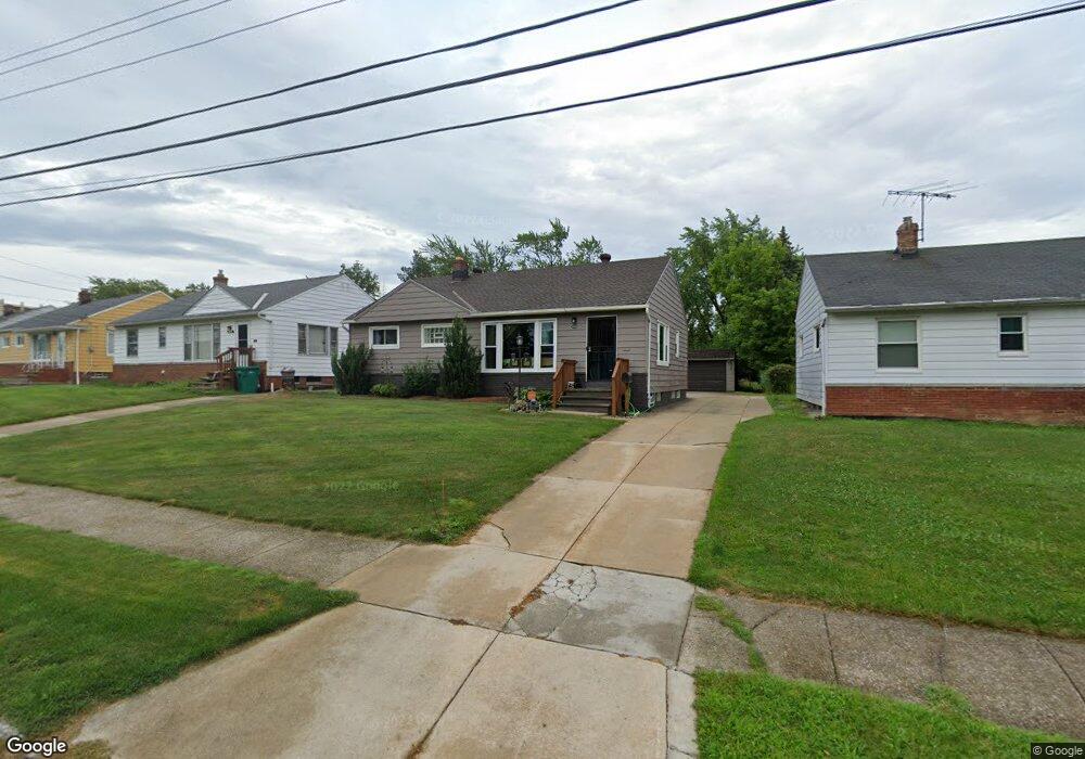
20740 Applegate Rd Maple Heights, OH 44137
Estimated Value: $124,000 - $150,000
3
Beds
1
Bath
1,033
Sq Ft
$133/Sq Ft
Est. Value
About This Home
This home is located at 20740 Applegate Rd, Maple Heights, OH 44137 and is currently estimated at $137,100, approximately $132 per square foot. 20740 Applegate Rd is a home located in Cuyahoga County with nearby schools including Abraham Lincoln Elementary School, Rockside/ J.F. Kennedy School, and Barack Obama School.
Ownership History
Date
Name
Owned For
Owner Type
Purchase Details
Closed on
Sep 21, 2015
Sold by
Meyers Janice M and Gladish Pamela Sue
Bought by
Brown Dannie and Brown Patty
Current Estimated Value
Purchase Details
Closed on
Sep 2, 2015
Sold by
Estate Of Gary Edward Gladish
Bought by
Gladish Pamela Sue
Purchase Details
Closed on
Mar 28, 1985
Sold by
Gladish Edward J and Gladish Viola M
Bought by
Gladish Edward J and Gladish Viola M
Purchase Details
Closed on
Jan 1, 1975
Bought by
Gladish Edward J and Gladish Viola M
Create a Home Valuation Report for This Property
The Home Valuation Report is an in-depth analysis detailing your home's value as well as a comparison with similar homes in the area
Home Values in the Area
Average Home Value in this Area
Purchase History
| Date | Buyer | Sale Price | Title Company |
|---|---|---|---|
| Brown Dannie | $50,000 | Harvard Title Agency Llc | |
| Gladish Pamela Sue | -- | Attorney | |
| Gladish Edward J | -- | -- | |
| Gladish Edward J | -- | -- |
Source: Public Records
Tax History
| Year | Tax Paid | Tax Assessment Tax Assessment Total Assessment is a certain percentage of the fair market value that is determined by local assessors to be the total taxable value of land and additions on the property. | Land | Improvement |
|---|---|---|---|---|
| 2024 | $3,794 | $42,210 | $9,030 | $33,180 |
| 2023 | $2,916 | $27,650 | $5,950 | $21,700 |
| 2022 | $2,905 | $27,650 | $5,950 | $21,700 |
| 2021 | $3,099 | $27,650 | $5,950 | $21,700 |
| 2020 | $2,645 | $20,970 | $4,520 | $16,450 |
| 2019 | $2,629 | $59,900 | $12,900 | $47,000 |
| 2018 | $2,654 | $20,970 | $4,520 | $16,450 |
| 2017 | $2,829 | $22,470 | $4,480 | $17,990 |
| 2016 | $2,734 | $22,470 | $4,480 | $17,990 |
| 2015 | $2,819 | $22,470 | $4,480 | $17,990 |
| 2014 | $2,819 | $24,680 | $4,940 | $19,740 |
Source: Public Records
Map
Nearby Homes
- 123 Willard Ave
- 5424 Fairtree Rd
- 54 Willard Ave
- 21607 Libby Rd
- 66 Hubbell Way
- 58 Hubbell Way
- 62 Hubbell Way
- 54 Hubbell Way
- 61 Hubbell Way
- 0 Hubbell Cir
- 21202 Gardenview Dr
- 57 Hubbell Way
- 339 Grand Blvd
- 419 Center Rd
- 19113 Watercrest Ave
- 20806 Clare Ave
- 21202 Hillgrove Ave
- 5385 Bartlett Rd
- 21860 Louis Rd
- 541 Helper Dr
- 20744 Applegate Rd
- 20736 Applegate Rd
- 20748 Applegate Rd
- 20732 Applegate Rd
- 20758 Bowling Green Rd
- 20752 Applegate Rd
- 20728 Applegate Rd
- 20754 Bowling Green Rd
- 20735 Applegate Rd
- 20751 Applegate Rd
- 20724 Applegate Rd
- 20756 Applegate Rd
- 20731 Applegate Rd
- 20755 Applegate Rd
- 20727 Applegate Rd
- 20720 Applegate Rd
- 20777 Bowling Green Rd
- 20746 Bowling Green Rd
- 20723 Applegate Rd
- 20742 Bowling Green Rd
Your Personal Tour Guide
Ask me questions while you tour the home.