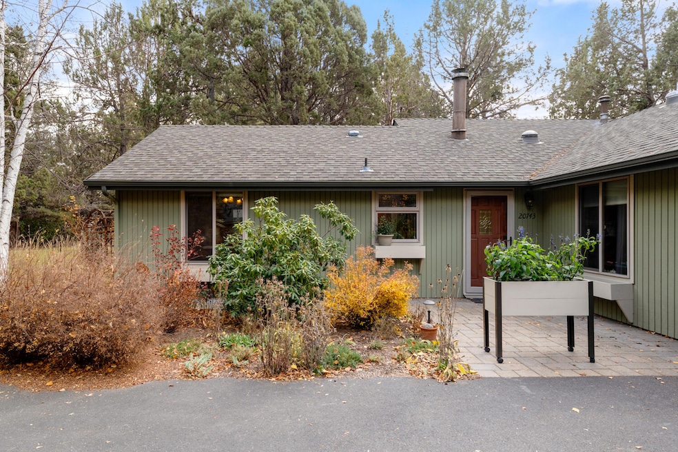
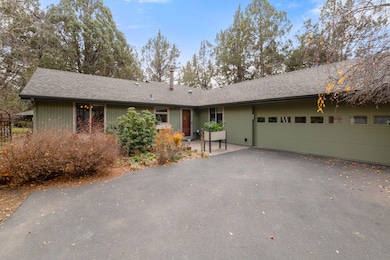
20743 Blacksmith Cir Bend, OR 97702
Old Farm District NeighborhoodEstimated payment $3,113/month
Highlights
- Northwest Architecture
- Vaulted Ceiling
- 2 Car Attached Garage
- Territorial View
- Covered Patio or Porch
- Double Pane Windows
About This Home
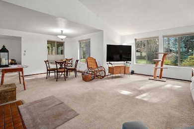
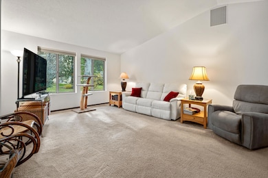
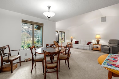
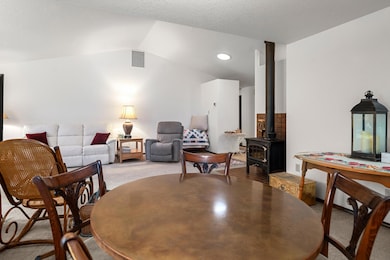
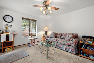
Welcome to this bright and inviting single-level home in the peaceful Nottingham Square neighborhood. The open floor plan features vaulted ceilings and fresh interior paint. With 2 bedrooms + an office, this home offers flexibility. Stay comfortable year-round with A/C and a cozy wood stove for chilly evenings. Enjoy the private backyard with pavers, a front porch for morning coffee, and even a catio for your furry pals! Located just to the west of the irrigation canal, you can spend your summer evenings relaxing to the sound of flowing water. The property backs to HOA-maintained common space for added privacy. The HOA takes care of irrigation, lawn maintenance and road snow removal, keeping the neighborhood beautifully maintained. A NEW ROOF, abundant storage, and a quiet cul-de-sac location make this home truly desirable. Enjoy nearby walking trails, open areas, and the convenience of being just minutes from Alpenglow Park, the Larkspur Community Center, and the historic canal trail
Listing Agent
Coldwell Banker Bain Brokerage Phone: 541-896-1263 License #201205424 Listed on: 11/13/2025

Home Details
Home Type
- Single Family
Est. Annual Taxes
- $3,269
Year Built
- Built in 1982
Lot Details
- 6,970 Sq Ft Lot
- Landscaped
- Level Lot
- Front and Back Yard Sprinklers
- Zoning described as RS
HOA Fees
- $175 Monthly HOA Fees
Parking
- 2 Car Attached Garage
Home Design
- Northwest Architecture
- Stem Wall Foundation
- Frame Construction
- Composition Roof
Interior Spaces
- 1,516 Sq Ft Home
- 1-Story Property
- Vaulted Ceiling
- Ceiling Fan
- Double Pane Windows
- Territorial Views
Kitchen
- Oven
- Range
- Microwave
- Dishwasher
- Laminate Countertops
- Disposal
Flooring
- Carpet
- Laminate
Bedrooms and Bathrooms
- 2 Bedrooms
- Linen Closet
- 2 Full Bathrooms
- Bathtub with Shower
- Solar Tube
Laundry
- Dryer
- Washer
Home Security
- Carbon Monoxide Detectors
- Fire and Smoke Detector
Outdoor Features
- Covered Patio or Porch
Schools
- Silver Rail Elementary School
- High Desert Middle School
- Caldera High School
Utilities
- Forced Air Heating and Cooling System
- Heating System Uses Natural Gas
- Heating System Uses Wood
- Water Heater
Listing and Financial Details
- Legal Lot and Block PT 6, 7 / 10
- Assessor Parcel Number 120603
Community Details
Overview
- Nottingham Square Subdivision
- On-Site Maintenance
Recreation
- Community Playground
- Park
- Trails
Map
Home Values in the Area
Average Home Value in this Area
Tax History
| Year | Tax Paid | Tax Assessment Tax Assessment Total Assessment is a certain percentage of the fair market value that is determined by local assessors to be the total taxable value of land and additions on the property. | Land | Improvement |
|---|---|---|---|---|
| 2025 | $3,269 | $193,450 | -- | -- |
| 2024 | $3,145 | $187,820 | -- | -- |
| 2023 | $2,915 | $182,350 | $0 | $0 |
| 2022 | $2,720 | $171,890 | $0 | $0 |
| 2021 | $2,724 | $166,890 | $0 | $0 |
| 2020 | $2,584 | $166,890 | $0 | $0 |
| 2019 | $2,512 | $162,030 | $0 | $0 |
| 2018 | $2,442 | $157,320 | $0 | $0 |
| 2017 | $2,370 | $152,740 | $0 | $0 |
| 2016 | $2,260 | $148,300 | $0 | $0 |
| 2015 | $2,198 | $143,990 | $0 | $0 |
| 2014 | $2,199 | $139,800 | $0 | $0 |
Property History
| Date | Event | Price | List to Sale | Price per Sq Ft |
|---|---|---|---|---|
| 02/04/2026 02/04/26 | Pending | -- | -- | -- |
| 11/13/2025 11/13/25 | For Sale | $519,000 | -- | $342 / Sq Ft |
Purchase History
| Date | Type | Sale Price | Title Company |
|---|---|---|---|
| Warranty Deed | $800,000 | Western Title & Escrow |
Mortgage History
| Date | Status | Loan Amount | Loan Type |
|---|---|---|---|
| Open | $117,250 | New Conventional |
Source: Oregon Datashare
MLS Number: 220211943
APN: 120603
Disclaimer: Certain information contained herein is derived from information provided by parties other than Homes.com. All information provided is deemed reliable, but is not guaranteed to be accurate and should be independently verified.
![]() © 2026 Oregon Datashare (KCAR | MLSCO | SOMLS). All rights reserved. The data relating to real estate for sale on this web site comes in part from the Internet Data Exchange Program of the Oregon Datashare. Real estate listings held by IDX Brokerage firms other than Ten-X are marked with the Internet Data Exchange logo or the Internet Data Exchange thumbnail logo and detailed information about them includes the name of the listing Brokers. Information provided is for consumers' personal, non-commercial use and may not be used for any purpose other than to identify prospective properties the viewer may be interested in purchasing. The consumer will not copy, retransmit nor redistribute any of the content from this website. Information provided is deemed reliable, but not guaranteed.
© 2026 Oregon Datashare (KCAR | MLSCO | SOMLS). All rights reserved. The data relating to real estate for sale on this web site comes in part from the Internet Data Exchange Program of the Oregon Datashare. Real estate listings held by IDX Brokerage firms other than Ten-X are marked with the Internet Data Exchange logo or the Internet Data Exchange thumbnail logo and detailed information about them includes the name of the listing Brokers. Information provided is for consumers' personal, non-commercial use and may not be used for any purpose other than to identify prospective properties the viewer may be interested in purchasing. The consumer will not copy, retransmit nor redistribute any of the content from this website. Information provided is deemed reliable, but not guaranteed.
- 61260 Sunflower Ln
- 61325 King Josiah Place
- 20657 Wild Goose Ln
- 61376 Robin Hood Ln
- 20634 Hummingbird Ln
- 61210 Larkspur Loop
- 20783 Canterbury Ct
- 20606 Songbird Ln
- 20749 Canterbury Ct
- 20650 Honeysuckle Ln
- 20627 White Dove Ln
- 61182 Larkspur Loop
- 61142 Brookhollow Dr
- 20580 Klahani Dr
- 20596 Button Brush Ave
- 61450 Little John Ln
- 20868 Tamar Ln
- 61346 Whitetail St
- 20513 SE Byron Ave
- 20809 SE Westview Dr
Ask me questions while you tour the home.