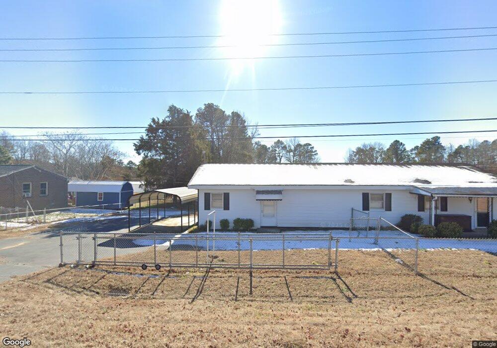
2077 W 10th St Roanoke Rapids, NC 27870
Estimated Value: $130,000 - $216,000
3
Beds
1
Bath
1,764
Sq Ft
$86/Sq Ft
Est. Value
About This Home
This home is located at 2077 W 10th St, Roanoke Rapids, NC 27870 and is currently estimated at $151,979, approximately $86 per square foot. 2077 W 10th St is a home located in Halifax County with nearby schools including Roanoke Rapids High School, Victory Christian Academy, and Miracle Tabernacle Christian School.
Ownership History
Date
Name
Owned For
Owner Type
Purchase Details
Closed on
Aug 10, 2024
Sold by
Spruill Derek L and Spruill Liliana C
Bought by
Ulrich Dominic
Current Estimated Value
Home Financials for this Owner
Home Financials are based on the most recent Mortgage that was taken out on this home.
Original Mortgage
$110,580
Outstanding Balance
$109,305
Interest Rate
6.77%
Mortgage Type
New Conventional
Estimated Equity
$42,674
Purchase Details
Closed on
Nov 23, 2020
Sold by
Faithful Jyvonica M and Faithful Joseph M
Bought by
Spruill Derek L and Spruill Liliana C
Home Financials for this Owner
Home Financials are based on the most recent Mortgage that was taken out on this home.
Original Mortgage
$55,000
Interest Rate
2.8%
Mortgage Type
New Conventional
Purchase Details
Closed on
Jun 2, 2016
Sold by
Harlow Peggy Stroud
Bought by
Faithful Jyvonica M
Create a Home Valuation Report for This Property
The Home Valuation Report is an in-depth analysis detailing your home's value as well as a comparison with similar homes in the area
Purchase History
| Date | Buyer | Sale Price | Title Company |
|---|---|---|---|
| Ulrich Dominic | $125,000 | None Listed On Document | |
| Ulrich Dominic | $125,000 | None Listed On Document | |
| Spruill Derek L | $70,000 | None Available | |
| Faithful Jyvonica M | -- | None Available |
Source: Public Records
Mortgage History
| Date | Status | Borrower | Loan Amount |
|---|---|---|---|
| Open | Ulrich Dominic | $110,580 | |
| Closed | Ulrich Dominic | $110,580 | |
| Previous Owner | Spruill Derek L | $55,000 |
Source: Public Records
Tax History
| Year | Tax Paid | Tax Assessment Tax Assessment Total Assessment is a certain percentage of the fair market value that is determined by local assessors to be the total taxable value of land and additions on the property. | Land | Improvement |
|---|---|---|---|---|
| 2025 | $11 | $89,000 | $11,900 | $77,100 |
| 2024 | $11 | $89,000 | $11,900 | $77,100 |
| 2023 | $1,062 | $76,700 | $11,900 | $64,800 |
| 2022 | $1,064 | $76,700 | $11,900 | $64,800 |
| 2021 | $1,031 | $76,700 | $11,900 | $64,800 |
| 2020 | $1,078 | $80,200 | $11,900 | $68,300 |
| 2019 | $628 | $74,400 | $11,900 | $62,500 |
| 2018 | $614 | $74,400 | $11,900 | $62,500 |
| 2017 | $616 | $74,400 | $11,900 | $62,500 |
| 2016 | $624 | $74,400 | $11,900 | $62,500 |
| 2015 | $592 | $74,400 | $11,900 | $62,500 |
| 2014 | $595 | $81,120 | $14,090 | $67,030 |
Source: Public Records
Map
Nearby Homes
- 123 Mobley St
- 54 Canterbury Ct
- 14 Canterbury Ct
- 154 Bishop Rd
- 268 Fairlane Dr
- 73 Thelma Rd
- 1118 Mapleton St
- 1509 Bolling Rd
- 139 Mina St
- 515 Oakwood Ave
- 1203 W 10th St
- 121 Gail Dr
- 289 Davie Smith St
- 215 Lakeview Dr
- 1005 W 8th St
- 906 Rapids St
- 817 Vance St
- 36 Bald Eagle Dr
- 34 Bald Eagle Dr
- 32 Bald Eagle Dr
Your Personal Tour Guide
Ask me questions while you tour the home.