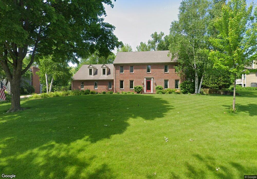
20770 Coventry Dr Brookfield, WI 53045
Estimated Value: $663,846 - $817,000
4
Beds
3
Baths
3,025
Sq Ft
$240/Sq Ft
Est. Value
About This Home
This home is located at 20770 Coventry Dr, Brookfield, WI 53045 and is currently estimated at $725,462, approximately $239 per square foot. 20770 Coventry Dr is a home located in Waukesha County with nearby schools including Brookfield Elementary School, Wisconsin Hills Middle School, and Brookfield Central High School.
Ownership History
Date
Name
Owned For
Owner Type
Purchase Details
Closed on
Feb 20, 2007
Sold by
Heinemann Stefan and Heinemann Charlene J
Bought by
Heinemann Stefan and Heinemann Charlene J
Current Estimated Value
Purchase Details
Closed on
Oct 21, 1996
Sold by
Heinemann Stefan and Heinemann Charlene J
Bought by
Heinemann Stefan and Heinemann Charlene J
Create a Home Valuation Report for This Property
The Home Valuation Report is an in-depth analysis detailing your home's value as well as a comparison with similar homes in the area
Home Values in the Area
Average Home Value in this Area
Purchase History
| Date | Buyer | Sale Price | Title Company |
|---|---|---|---|
| Heinemann Stefan | -- | None Available | |
| Heinemann Stefan | -- | None Available | |
| Heinemann Stefan | -- | -- |
Source: Public Records
Tax History
| Year | Tax Paid | Tax Assessment Tax Assessment Total Assessment is a certain percentage of the fair market value that is determined by local assessors to be the total taxable value of land and additions on the property. | Land | Improvement |
|---|---|---|---|---|
| 2024 | $6,320 | $562,800 | $145,000 | $417,800 |
| 2023 | $6,327 | $562,800 | $145,000 | $417,800 |
| 2022 | $6,786 | $471,200 | $140,000 | $331,200 |
| 2021 | $7,190 | $471,200 | $140,000 | $331,200 |
| 2020 | $7,484 | $471,200 | $140,000 | $331,200 |
| 2019 | $7,195 | $471,200 | $140,000 | $331,200 |
| 2018 | $6,778 | $432,400 | $140,000 | $292,400 |
| 2017 | $7,737 | $432,400 | $140,000 | $292,400 |
| 2016 | $6,868 | $432,400 | $140,000 | $292,400 |
| 2015 | $6,827 | $432,400 | $140,000 | $292,400 |
| 2014 | $7,082 | $432,400 | $140,000 | $292,400 |
| 2013 | $7,082 | $432,400 | $140,000 | $292,400 |
Source: Public Records
Map
Nearby Homes
- 20305 Downing Ct
- 2550 Harmony Cir
- 2465 Lionel Ct
- 2820 Norman Dr
- 1930 Cotton Tail Ln
- 1825 Derrin Ln
- Lt118 Berwick Ct
- Lt120 Berwick Ct
- Lt116 Berwick Ct
- Lt114 Berwick Ct
- 1775 Derrin Ln
- 2000 Kathlynn Ct
- 19775 Trilby Ct
- 19260 Brookdale Dr
- W221N3075 Greenwood Ct
- 1040 Lansdowne Ct Unit V6
- W224N2507 Ridgewood Ln
- 18860 N Hills Dr
- 18850 N Hills Dr
- 18865 Tanala Dr
- 20800 Coventry Dr
- 2355 Macaulay Dr
- 20785 Macaulay Dr
- 2365 Macaulay Dr
- 20815 Macaulay Dr
- 20785 Coventry Dr
- 20850 Coventry Dr
- 20755 Coventry Dr
- 20825 Coventry Dr
- 20715 Coventry Dr
- 20855 Macaulay Dr
- 20680 Coventry Dr
- 20880 Coventry Dr
- 20865 Coventry Dr
- 2360 Macaulay Dr
- 20800 Tennyson Dr
- 20775 Tennyson Dr
- 20895 Macaulay Dr
- 2380 Macaulay Dr
- 2370 Macaulay Dr
Your Personal Tour Guide
Ask me questions while you tour the home.