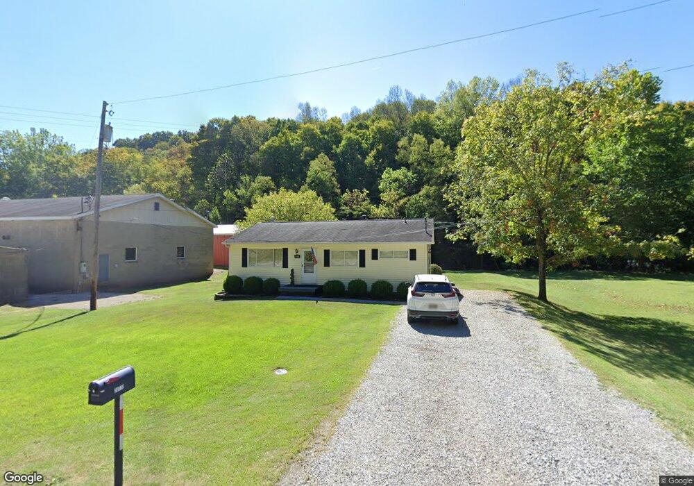
20770 State Route 550 Marietta, OH 45750
Estimated Value: $118,000 - $169,000
3
Beds
1
Bath
1,040
Sq Ft
$148/Sq Ft
Est. Value
About This Home
This home is located at 20770 State Route 550, Marietta, OH 45750 and is currently estimated at $154,217, approximately $148 per square foot. 20770 State Route 550 is a home located in Washington County with nearby schools including Warren High School, Veritas Classical Academy, and St. Mary Catholic School.
Ownership History
Date
Name
Owned For
Owner Type
Purchase Details
Closed on
Sep 6, 2019
Sold by
Summers Mary M and Sturm Mary M
Bought by
Wright Kathryn R
Current Estimated Value
Home Financials for this Owner
Home Financials are based on the most recent Mortgage that was taken out on this home.
Original Mortgage
$26,400
Outstanding Balance
$11,742
Interest Rate
3.7%
Mortgage Type
New Conventional
Estimated Equity
$142,475
Create a Home Valuation Report for This Property
The Home Valuation Report is an in-depth analysis detailing your home's value as well as a comparison with similar homes in the area
Home Values in the Area
Average Home Value in this Area
Purchase History
| Date | Buyer | Sale Price | Title Company |
|---|---|---|---|
| Wright Kathryn R | $33,000 | None Available |
Source: Public Records
Mortgage History
| Date | Status | Borrower | Loan Amount |
|---|---|---|---|
| Open | Wright Kathryn R | $26,400 |
Source: Public Records
Tax History Compared to Growth
Tax History
| Year | Tax Paid | Tax Assessment Tax Assessment Total Assessment is a certain percentage of the fair market value that is determined by local assessors to be the total taxable value of land and additions on the property. | Land | Improvement |
|---|---|---|---|---|
| 2024 | $1,275 | $33,750 | $6,750 | $27,000 |
| 2023 | $1,275 | $33,750 | $6,750 | $27,000 |
| 2022 | $1,270 | $33,750 | $6,750 | $27,000 |
| 2021 | $1,048 | $26,620 | $4,430 | $22,190 |
| 2020 | $1,047 | $26,620 | $4,430 | $22,190 |
| 2019 | $1,032 | $26,620 | $4,430 | $22,190 |
| 2018 | $961 | $24,040 | $3,860 | $20,180 |
| 2017 | $955 | $24,040 | $3,860 | $20,180 |
| 2016 | $1,224 | $24,040 | $3,860 | $20,180 |
| 2015 | $757 | $21,200 | $3,950 | $17,250 |
| 2014 | $1,091 | $21,200 | $3,950 | $17,250 |
| 2013 | $759 | $21,200 | $3,950 | $17,250 |
Source: Public Records
Map
Nearby Homes
- 735 Bramblewood Heights Rd
- 20043 State Route 550
- 20 Silver Globe Rd
- 204 Coventry Rd
- 146 Riverview Dr
- 106 Cheyenne Rd
- 747 Virginia St
- 645 Pearl Street Extension
- 1119 Lancaster St
- 417 Maple St
- 412 Lord St
- 309 Harmar St
- 977 Gilman Ave
- 407 Harmar St
- 905 W 4th St
- 603 Poplar Ave
- 202 Sacra Via St
- 619 3rd St
- 503 3rd St
- 722 1/2 3rd St
- 20825 Ohio 550
- 20700 State Route 550
- 20825 State Route 550
- 20660 State Route 550
- 20650 Ohio 550
- 20650 Oh 550
- 20650 St Rt 550
- 20630 Rt 550
- 20630 State Route 550
- 0 St Rt 550 Unit 3829523
- 400 Belavista Dr
- 365 Belavista Dr
- 20565 Ohio 550
- 355 Belavista Dr
- 165 Dodd Run Rd
- 390 Belavista Dr
- 370 Belavista Dr
- 350 Belavista Dr
- 285 Belavista Dr
- 330 Belavista Dr