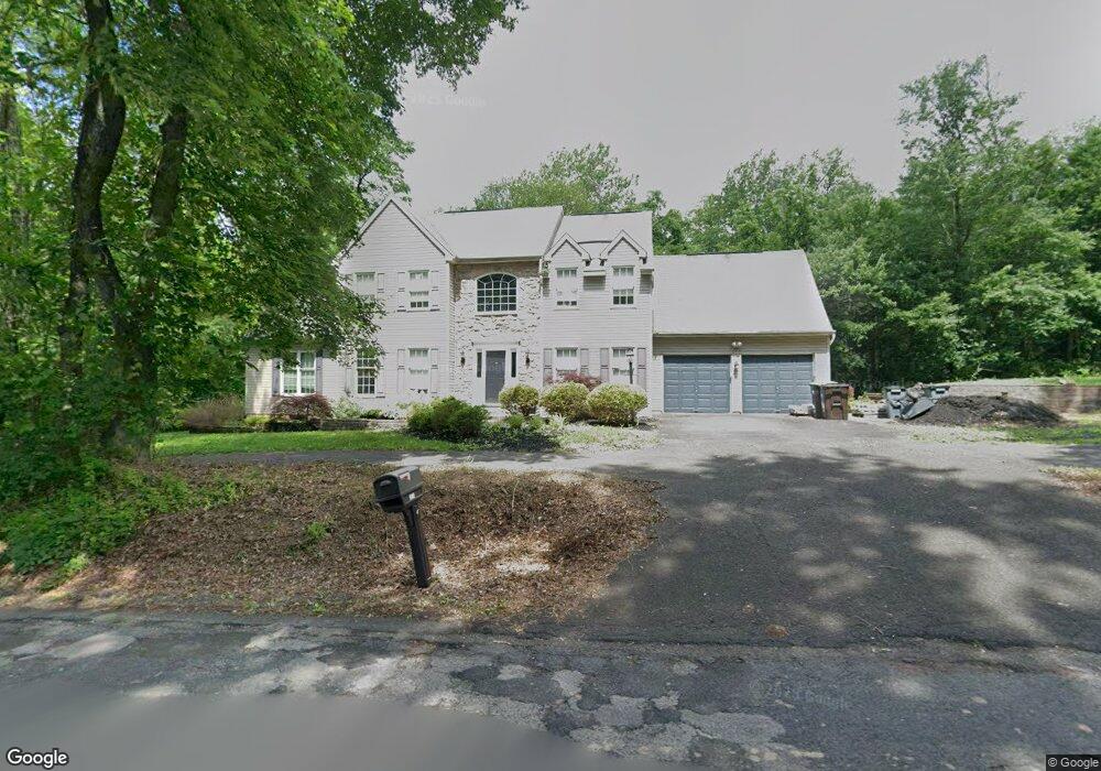
2078 Turk Rd Doylestown, PA 18901
Estimated Value: $608,000 - $759,892
4
Beds
3
Baths
2,596
Sq Ft
$271/Sq Ft
Est. Value
About This Home
This home is located at 2078 Turk Rd, Doylestown, PA 18901 and is currently estimated at $704,223, approximately $271 per square foot. 2078 Turk Rd is a home located in Bucks County with nearby schools including Kutz Elementary School, Lenape Middle School, and Central Bucks High School-West.
Ownership History
Date
Name
Owned For
Owner Type
Purchase Details
Closed on
Feb 17, 2012
Sold by
Sodell Stuart H and Sodell Judith
Bought by
Ohara Gerald P
Current Estimated Value
Home Financials for this Owner
Home Financials are based on the most recent Mortgage that was taken out on this home.
Original Mortgage
$236,000
Outstanding Balance
$161,452
Interest Rate
3.86%
Mortgage Type
New Conventional
Estimated Equity
$542,771
Purchase Details
Closed on
Sep 14, 1999
Sold by
Windridge Inc
Bought by
Sodell Stuart H and Sodell Judith
Home Financials for this Owner
Home Financials are based on the most recent Mortgage that was taken out on this home.
Original Mortgage
$208,000
Interest Rate
6.75%
Create a Home Valuation Report for This Property
The Home Valuation Report is an in-depth analysis detailing your home's value as well as a comparison with similar homes in the area
Home Values in the Area
Average Home Value in this Area
Purchase History
| Date | Buyer | Sale Price | Title Company |
|---|---|---|---|
| Ohara Gerald P | $295,000 | None Available | |
| Sodell Stuart H | $244,900 | -- |
Source: Public Records
Mortgage History
| Date | Status | Borrower | Loan Amount |
|---|---|---|---|
| Open | Ohara Gerald P | $236,000 | |
| Previous Owner | Sodell Stuart H | $208,000 |
Source: Public Records
Tax History Compared to Growth
Tax History
| Year | Tax Paid | Tax Assessment Tax Assessment Total Assessment is a certain percentage of the fair market value that is determined by local assessors to be the total taxable value of land and additions on the property. | Land | Improvement |
|---|---|---|---|---|
| 2025 | $7,864 | $44,440 | $6,680 | $37,760 |
| 2024 | $7,864 | $44,440 | $6,680 | $37,760 |
| 2023 | $7,499 | $44,440 | $6,680 | $37,760 |
| 2022 | $7,415 | $44,440 | $6,680 | $37,760 |
| 2021 | $7,263 | $44,440 | $6,680 | $37,760 |
| 2020 | $7,229 | $44,440 | $6,680 | $37,760 |
| 2019 | $7,152 | $44,440 | $6,680 | $37,760 |
| 2018 | $7,129 | $44,440 | $6,680 | $37,760 |
| 2017 | $7,074 | $44,440 | $6,680 | $37,760 |
| 2016 | $7,029 | $44,440 | $6,680 | $37,760 |
| 2015 | -- | $44,440 | $6,680 | $37,760 |
| 2014 | -- | $44,440 | $6,680 | $37,760 |
Source: Public Records
Map
Nearby Homes
- 82 Avalon Ct Unit 2005
- 17 Addison Ct Unit 2703
- 137 Pebble Woods Dri Pebble Woods Dr
- 78 Tower Hill Rd
- 60 Quarry Rd
- 1 Squirrel Rd
- 2320 Turk Rd
- 272 Fox Chase Ln
- 125 Edison Furlong Rd
- 45 Bedford Ave
- 3 Steeplechase Dr
- 403 S Main St Unit S201
- 21 Shady Springs Dr
- 89 Homestead Dr
- 420 Edison Furlong Rd
- 195 Lafayette St
- 236 Green St
- 9 Mill Creek Dr
- 223 Cherry Ln
- 152 Watercrest Dr