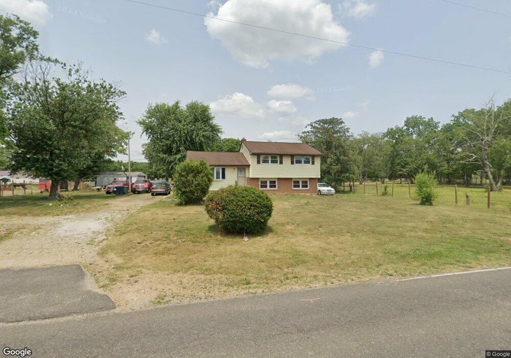
2079 Winslow Rd Williamstown, NJ 08094
Monroe Township Gloucester NeighborhoodEstimated Value: $120,000 - $379,000
5
Beds
2
Baths
1,780
Sq Ft
$164/Sq Ft
Est. Value
About This Home
This home is located at 2079 Winslow Rd, Williamstown, NJ 08094 and is currently estimated at $291,639, approximately $163 per square foot. 2079 Winslow Rd is a home located in Gloucester County with nearby schools including Williamstown High School, St. Mary School, and Finest of the Wheat Christian.
Ownership History
Date
Name
Owned For
Owner Type
Purchase Details
Closed on
Jun 13, 2019
Sold by
Hamm William A and Hamm Ruth
Bought by
Burnett Ralph
Current Estimated Value
Home Financials for this Owner
Home Financials are based on the most recent Mortgage that was taken out on this home.
Original Mortgage
$73,612
Interest Rate
4%
Mortgage Type
FHA
Purchase Details
Closed on
Jun 25, 1992
Bought by
Hamm William and Hamm Ruth
Create a Home Valuation Report for This Property
The Home Valuation Report is an in-depth analysis detailing your home's value as well as a comparison with similar homes in the area
Home Values in the Area
Average Home Value in this Area
Purchase History
| Date | Buyer | Sale Price | Title Company |
|---|---|---|---|
| Burnett Ralph | $75,000 | Amrock | |
| Hamm William | $88,000 | -- |
Source: Public Records
Mortgage History
| Date | Status | Borrower | Loan Amount |
|---|---|---|---|
| Previous Owner | Burnett Ralph | $73,612 |
Source: Public Records
Tax History Compared to Growth
Tax History
| Year | Tax Paid | Tax Assessment Tax Assessment Total Assessment is a certain percentage of the fair market value that is determined by local assessors to be the total taxable value of land and additions on the property. | Land | Improvement |
|---|---|---|---|---|
| 2025 | $4,988 | $136,200 | $38,600 | $97,600 |
| 2024 | $4,951 | $136,200 | $38,600 | $97,600 |
| 2023 | $4,951 | $136,200 | $38,600 | $97,600 |
| 2022 | $4,928 | $136,200 | $38,600 | $97,600 |
| 2021 | $4,924 | $136,200 | $38,600 | $97,600 |
| 2020 | $4,954 | $136,200 | $38,600 | $97,600 |
| 2019 | $4,924 | $136,200 | $38,600 | $97,600 |
| 2018 | $4,843 | $136,200 | $38,600 | $97,600 |
| 2017 | $5,572 | $157,300 | $45,000 | $112,300 |
| 2016 | $5,501 | $157,300 | $45,000 | $112,300 |
| 2015 | $5,343 | $157,300 | $45,000 | $112,300 |
| 2014 | $5,188 | $157,300 | $45,000 | $112,300 |
Source: Public Records
Map
Nearby Homes
- 2384 Winslow Rd
- 1753 Winslow Rd
- 746 E Malaga Rd
- 1700 Winslow Rd
- 638 Mills Ln
- 1742 Corkery Ln
- L:9 Huber Ave
- 490 Huber Ave
- Allegheny Plan at Acorn Lane
- Columbia Plan at Acorn Lane
- Hudson Plan at Acorn Lane
- 291 Broadlane Rd
- 1304 Morgan Rd
- 240 Buckhorn Dr
- 1430 Corkery Ln
- 104 Chinkapin Ave
- 1412 Johanna Ct
- 0 Black Horse Pike Unit NJGL2064300
- 0 Black Horse Pike Unit NJGL2064170
- 625 Huber Ave
- 2057 Winslow Rd
- 2084 Winslow Rd
- 2042 Winslow Rd
- 739 Lebanon Ave
- 2137 Winslow Rd
- 2137 Winslow Rd
- 2020 Winslow Rd
- 0 Lebanon Ave
- 626 Lebanon Ave
- 2011 Winslow Rd
- 745 Lebanon Ave
- 745 Lebanon Ave
- 745 Lebanon Ave Unit 747
- 747 Lebanon Ave Unit 745, 747
- 747 Lebanon Ave
- 746 Lebanon Ave
- 640 Lebanon Ave
- 2008 Winslow Rd
- 654 Lebanon Ave
- 1999 Winslow Rd