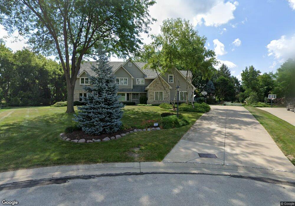
20795 Bridgetown Ct Brookfield, WI 53045
Estimated Value: $921,000 - $1,127,000
4
Beds
4
Baths
3,889
Sq Ft
$263/Sq Ft
Est. Value
About This Home
This home is located at 20795 Bridgetown Ct, Brookfield, WI 53045 and is currently estimated at $1,022,988, approximately $263 per square foot. 20795 Bridgetown Ct is a home located in Waukesha County with nearby schools including Brookfield Elementary School, Wisconsin Hills Middle School, and Brookfield Central High School.
Ownership History
Date
Name
Owned For
Owner Type
Purchase Details
Closed on
Aug 20, 2015
Sold by
Roach Donald G and Roach Ann M
Bought by
Zundel Michael T and Zundel Lindsay J
Current Estimated Value
Home Financials for this Owner
Home Financials are based on the most recent Mortgage that was taken out on this home.
Original Mortgage
$532,000
Outstanding Balance
$418,557
Interest Rate
4.04%
Mortgage Type
New Conventional
Estimated Equity
$604,431
Create a Home Valuation Report for This Property
The Home Valuation Report is an in-depth analysis detailing your home's value as well as a comparison with similar homes in the area
Home Values in the Area
Average Home Value in this Area
Purchase History
| Date | Buyer | Sale Price | Title Company |
|---|---|---|---|
| Zundel Michael T | $6,665,000 | None Available |
Source: Public Records
Mortgage History
| Date | Status | Borrower | Loan Amount |
|---|---|---|---|
| Open | Zundel Michael T | $532,000 |
Source: Public Records
Tax History Compared to Growth
Tax History
| Year | Tax Paid | Tax Assessment Tax Assessment Total Assessment is a certain percentage of the fair market value that is determined by local assessors to be the total taxable value of land and additions on the property. | Land | Improvement |
|---|---|---|---|---|
| 2024 | $9,121 | $802,700 | $224,700 | $578,000 |
| 2023 | $9,141 | $802,700 | $224,700 | $578,000 |
| 2022 | $9,643 | $662,000 | $214,000 | $448,000 |
| 2021 | $10,226 | $662,000 | $214,000 | $448,000 |
| 2020 | $10,613 | $662,000 | $214,000 | $448,000 |
| 2019 | $10,214 | $662,000 | $214,000 | $448,000 |
| 2018 | $10,337 | $652,000 | $200,000 | $452,000 |
| 2017 | $10,304 | $652,000 | $200,000 | $452,000 |
| 2016 | $11,397 | $709,300 | $200,000 | $509,300 |
| 2015 | $11,308 | $709,300 | $200,000 | $509,300 |
| 2014 | $11,731 | $709,300 | $200,000 | $509,300 |
| 2013 | $11,731 | $709,300 | $200,000 | $509,300 |
Source: Public Records
Map
Nearby Homes
- 21330 Hollycrest Ct
- Lt119 Berwick Ct
- Lt117 Berwick Ct
- Lt115 Berwick Ct
- Lt120 Berwick Ct
- Lt116 Berwick Ct
- Lt114 Berwick Ct
- Lt118 Berwick Ct
- 20780 Tennyson Dr
- 2410 Talbots Ln
- 21300 Astolat Dr
- 21380 Woodchuck Ln
- N31W22134 Green Rd
- W222N2872 Timberwood Ct
- 21965 Valiant Dr
- 21445 Gumina Rd
- 7034 Stonewood Ln
- 7038 Stonewood Ln
- 7018 Stonewood Ln
- 7022 Stonewood Ln
- 20835 Bridgetown Ct
- 20790 Bridgetown Ct
- 20800 Lincolnshire Ct
- 20750 Lincolnshire Ct
- 2765 Lancaster Ct
- 20840 Lincolnshire Ct
- 2760 Norman Dr
- 2820 Norman Dr
- 20740 Lincolnshire Ct
- 2815 Lancaster Ct
- 20755 Manchester Ct
- 2740 Norman Dr
- 2760 Lancaster Ct
- 20805 Lincolnshire Ct
- 20765 Lincolnshire Ct
- 2840 Norman Dr
- 20650 Spencer Ct
- 20855 Lincolnshire Ct
- 20735 Lincolnshire Ct
- 2790 Lancaster Ct