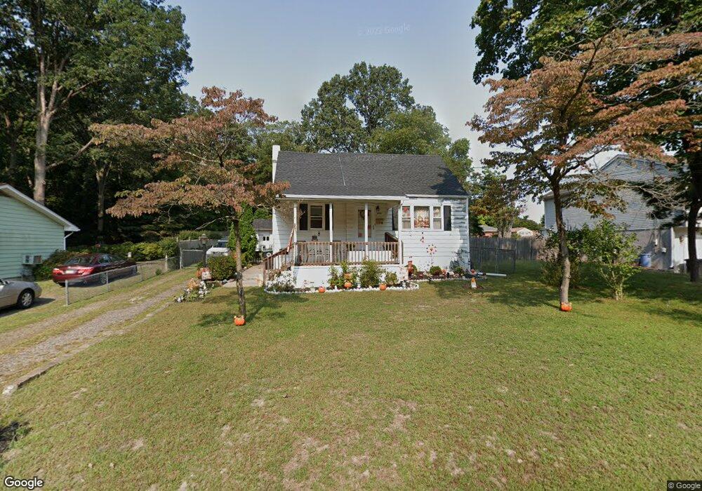
208 Cedar Ave Lindenwold, NJ 08021
Estimated Value: $243,663 - $313,000
--
Bed
--
Bath
1,409
Sq Ft
$203/Sq Ft
Est. Value
About This Home
This home is located at 208 Cedar Ave, Lindenwold, NJ 08021 and is currently estimated at $285,416, approximately $202 per square foot. 208 Cedar Ave is a home located in Camden County with nearby schools including Memorial Middle School, Lindenwold High School, and South Jersey Sudbury School.
Ownership History
Date
Name
Owned For
Owner Type
Purchase Details
Closed on
Dec 21, 2020
Sold by
Hopkins Barbara A
Bought by
Hopkins Robert A and Hopkins Jason E
Current Estimated Value
Purchase Details
Closed on
Jul 24, 1999
Sold by
Stewart Ronald T
Bought by
Hopkins Robert A and Hopkins Barbara A
Home Financials for this Owner
Home Financials are based on the most recent Mortgage that was taken out on this home.
Original Mortgage
$74,450
Interest Rate
7.54%
Mortgage Type
VA
Create a Home Valuation Report for This Property
The Home Valuation Report is an in-depth analysis detailing your home's value as well as a comparison with similar homes in the area
Home Values in the Area
Average Home Value in this Area
Purchase History
| Date | Buyer | Sale Price | Title Company |
|---|---|---|---|
| Hopkins Robert A | -- | None Listed On Document | |
| Hopkins Robert A | $73,000 | -- |
Source: Public Records
Mortgage History
| Date | Status | Borrower | Loan Amount |
|---|---|---|---|
| Previous Owner | Hopkins Robert A | $74,450 |
Source: Public Records
Tax History Compared to Growth
Tax History
| Year | Tax Paid | Tax Assessment Tax Assessment Total Assessment is a certain percentage of the fair market value that is determined by local assessors to be the total taxable value of land and additions on the property. | Land | Improvement |
|---|---|---|---|---|
| 2025 | $6,518 | $131,800 | $37,900 | $93,900 |
| 2024 | $6,553 | $131,800 | $37,900 | $93,900 |
| 2023 | $6,553 | $131,800 | $37,900 | $93,900 |
| 2022 | $6,547 | $131,800 | $37,900 | $93,900 |
| 2021 | $6,477 | $131,800 | $37,900 | $93,900 |
| 2020 | $6,688 | $131,800 | $37,900 | $93,900 |
| 2019 | $6,747 | $131,800 | $37,900 | $93,900 |
| 2018 | $6,730 | $131,800 | $37,900 | $93,900 |
| 2017 | $6,528 | $131,800 | $37,900 | $93,900 |
| 2016 | $6,382 | $131,800 | $37,900 | $93,900 |
| 2015 | $5,863 | $131,800 | $37,900 | $93,900 |
| 2014 | $5,597 | $131,800 | $37,900 | $93,900 |
Source: Public Records
Map
Nearby Homes
- 409 Cedar Ave
- 5 S White Horse Pike
- 700 Elizabeth Ave
- 450 Hawthorne St
- 25 State Ave
- 434 E Maple Ave
- 109 State Ave
- 713 Myrtle Ave
- 205 State Ave
- 13 Hidden Dr
- 961 - E Gibbsboro Rd
- 725 E Linden Ave
- 38 California Ave
- 104 W Park Ave
- 805 Myrtle Ave
- 513 N White Horse Pike
- 470 Wilson Ave
- 135 Madison Ave
- 46 Watson Blvd
- 161 Ohio Ave
- 202 Cedar Ave
- 214 Cedar Ave
- 205 Cedar Ave
- 220 Cedar Ave
- 219 Myrtle Ave
- 215 Cedar Ave
- 221 Myrtle Ave
- 217 Cedar Ave
- 212 S Lowell Ave
- 231 Myrtle Ave
- 216 Myrtle Ave
- 304 S Lowell Ave
- 220 Myrtle Ave
- 224 Chestnut Ave
- 308 S Lowell Ave
- 237 Myrtle Ave
- 224 Myrtle Ave
- 312 S Lowell Ave
- 230 Myrtle Ave
- 209 E Elm Ave