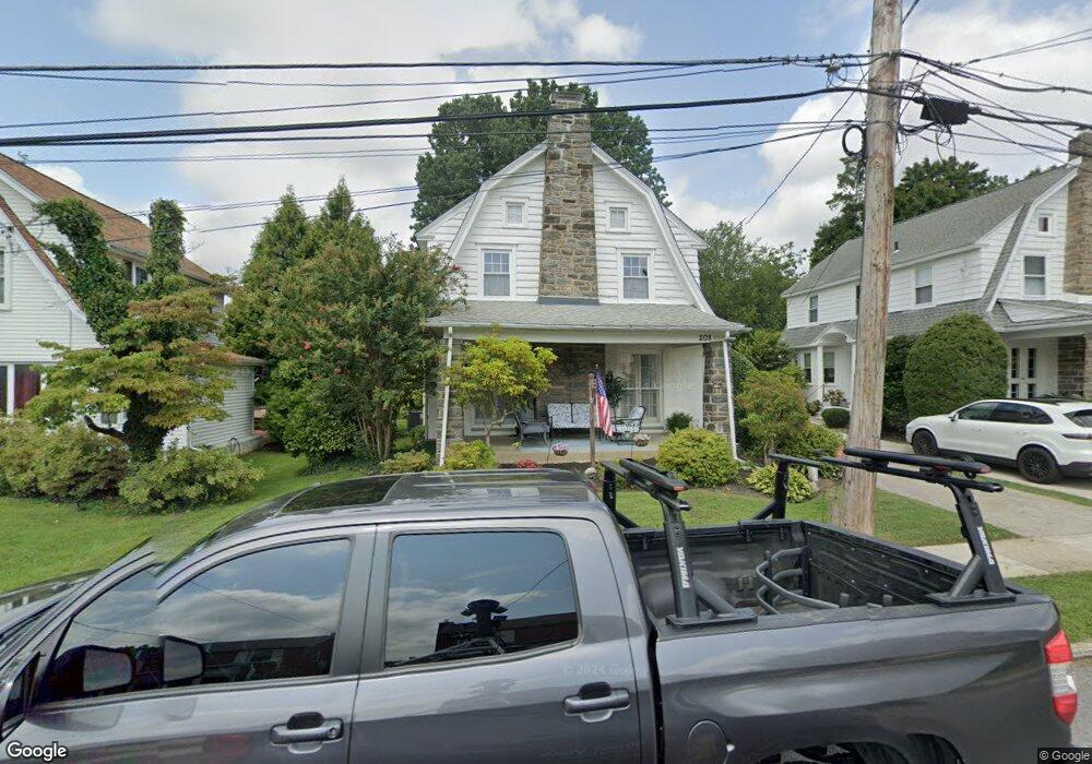
208 Kenmore Rd Havertown, PA 19083
Estimated Value: $480,000 - $507,301
3
Beds
2
Baths
1,743
Sq Ft
$284/Sq Ft
Est. Value
About This Home
This home is located at 208 Kenmore Rd, Havertown, PA 19083 and is currently estimated at $495,825, approximately $284 per square foot. 208 Kenmore Rd is a home located in Delaware County with nearby schools including Chatham Park Elementary School, Haverford Middle School, and Haverford Senior High School.
Ownership History
Date
Name
Owned For
Owner Type
Purchase Details
Closed on
May 12, 2021
Sold by
Pierce Mark V and Estate Of Imogene R Maelhorn
Bought by
Collison Evan
Current Estimated Value
Home Financials for this Owner
Home Financials are based on the most recent Mortgage that was taken out on this home.
Original Mortgage
$260,000
Outstanding Balance
$234,884
Interest Rate
2.9%
Mortgage Type
New Conventional
Estimated Equity
$260,941
Purchase Details
Closed on
Jul 11, 1956
Bought by
Maelhorn Eugene R
Create a Home Valuation Report for This Property
The Home Valuation Report is an in-depth analysis detailing your home's value as well as a comparison with similar homes in the area
Home Values in the Area
Average Home Value in this Area
Purchase History
| Date | Buyer | Sale Price | Title Company |
|---|---|---|---|
| Collison Evan | $325,000 | None Available | |
| Maelhorn Eugene R | -- | -- |
Source: Public Records
Mortgage History
| Date | Status | Borrower | Loan Amount |
|---|---|---|---|
| Open | Collison Evan | $260,000 |
Source: Public Records
Tax History Compared to Growth
Tax History
| Year | Tax Paid | Tax Assessment Tax Assessment Total Assessment is a certain percentage of the fair market value that is determined by local assessors to be the total taxable value of land and additions on the property. | Land | Improvement |
|---|---|---|---|---|
| 2025 | $8,062 | $313,540 | $99,680 | $213,860 |
| 2024 | $8,062 | $313,540 | $99,680 | $213,860 |
| 2023 | $7,833 | $313,540 | $99,680 | $213,860 |
| 2022 | $7,650 | $313,540 | $99,680 | $213,860 |
| 2021 | $12,462 | $313,540 | $99,680 | $213,860 |
| 2020 | $6,723 | $144,640 | $50,480 | $94,160 |
| 2019 | $6,599 | $144,640 | $50,480 | $94,160 |
| 2018 | $6,485 | $144,640 | $0 | $0 |
| 2017 | $6,348 | $144,640 | $0 | $0 |
| 2016 | $794 | $144,640 | $0 | $0 |
| 2015 | $810 | $144,640 | $0 | $0 |
| 2014 | $794 | $144,640 | $0 | $0 |
Source: Public Records
Map
Nearby Homes
- 204 E Manoa Rd
- 100 Brookline Blvd
- 210 Farnham Rd
- 2 D E Manoa St
- 1216 Darby Rd
- 501 E Manoa Rd
- 16 Chelten Rd
- 524 Sagamore Rd
- 304 Earlington Rd
- 664 Washington Ave
- 214 Brentwood Rd
- 100 Yale Rd
- 171 Juniper Rd
- 26 E Turnbull Ave
- 5 W Turnbull Ave
- 142 Foster Ave
- 504 N Manoa Rd
- 231 Hastings Ave
- 11 Woodbine Rd
- 447 W Chester Pike
- 214 Kenmore Rd
- 204 Kenmore Rd
- 218 Kenmore Rd
- 211 Sagamore Rd
- 215 Sagamore Rd
- 207 Sagamore Rd
- 222 Kenmore Rd
- 203 Sagamore Rd
- 219 Sagamore Rd
- 215 Kenmore Rd
- 1107 Allston Rd
- 223 Sagamore Rd
- 1103 Allston Rd
- 209 Kenmore Rd
- 205 Kenmore Rd
- 224 Kenmore Rd
- 219 Kenmore Rd
- 1115 Allston Rd
- 203 Kenmore Rd
- 221 Kenmore Rd