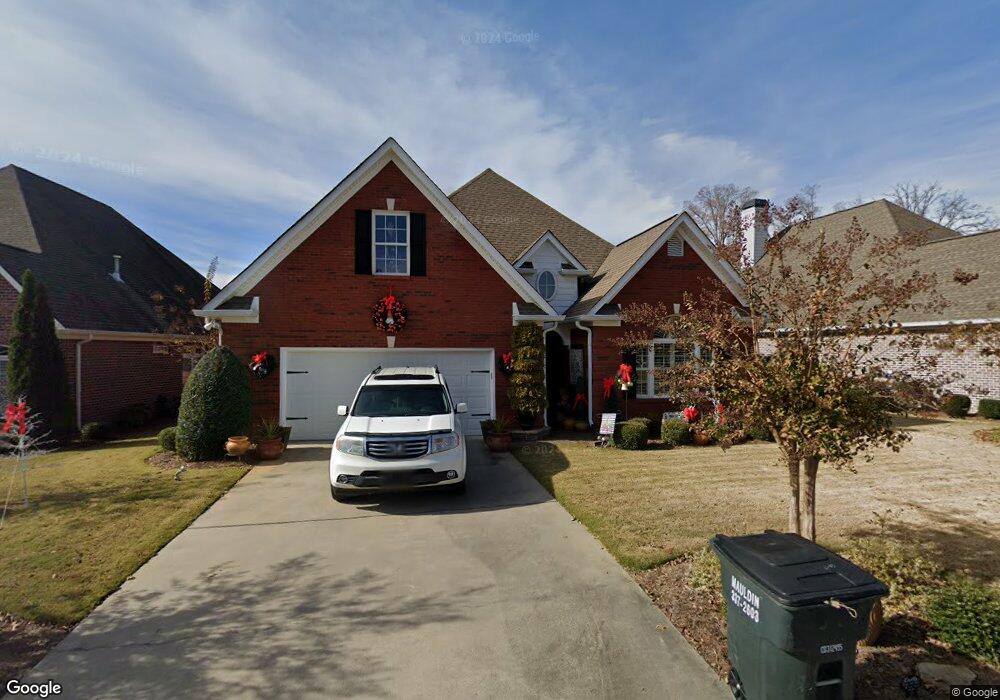
208 Lenox Rd SE Calhoun, GA 30701
Estimated Value: $359,000 - $419,000
3
Beds
2
Baths
2,165
Sq Ft
$179/Sq Ft
Est. Value
About This Home
This home is located at 208 Lenox Rd SE, Calhoun, GA 30701 and is currently estimated at $386,696, approximately $178 per square foot. 208 Lenox Rd SE is a home located in Gordon County with nearby schools including Calhoun Primary School, Calhoun Elementary School, and Calhoun Middle School.
Ownership History
Date
Name
Owned For
Owner Type
Purchase Details
Closed on
Sep 26, 2024
Sold by
Black Tracey D
Bought by
Black Jim L
Current Estimated Value
Purchase Details
Closed on
Oct 12, 2007
Sold by
Black Jim L
Bought by
Black Jim L and Black Tracey D
Purchase Details
Closed on
Mar 27, 2007
Sold by
Brent Stepp Construction C
Bought by
Black Jim L
Create a Home Valuation Report for This Property
The Home Valuation Report is an in-depth analysis detailing your home's value as well as a comparison with similar homes in the area
Home Values in the Area
Average Home Value in this Area
Purchase History
| Date | Buyer | Sale Price | Title Company |
|---|---|---|---|
| Black Jim L | -- | -- | |
| Black Jim L | -- | -- | |
| Black Jim L | $40,000 | -- |
Source: Public Records
Tax History Compared to Growth
Tax History
| Year | Tax Paid | Tax Assessment Tax Assessment Total Assessment is a certain percentage of the fair market value that is determined by local assessors to be the total taxable value of land and additions on the property. | Land | Improvement |
|---|---|---|---|---|
| 2024 | $1,866 | $123,480 | $16,000 | $107,480 |
| 2023 | $1,647 | $115,680 | $16,000 | $99,680 |
| 2022 | $963 | $103,200 | $15,200 | $88,000 |
| 2021 | $2,214 | $98,600 | $16,000 | $82,600 |
| 2020 | $2,032 | $91,960 | $16,000 | $75,960 |
| 2019 | $2,027 | $91,960 | $16,000 | $75,960 |
| 2018 | $883 | $93,720 | $17,600 | $76,120 |
| 2017 | $810 | $84,400 | $16,000 | $68,400 |
| 2016 | $808 | $84,000 | $16,000 | $68,000 |
| 2015 | $810 | $82,560 | $16,000 | $66,560 |
| 2014 | $810 | $84,280 | $11,200 | $73,080 |
Source: Public Records
Map
Nearby Homes
- 107 Savoy Place SE
- 220 Lenox Rd SE
- 209 Willowbrook Dr SE
- 114 Vinings Way SE
- 112 Willowbrook Dr SE
- 62 Professional Place Unit 30
- 200 Wildwood Cir SE
- 195 Dogwood Dr SE
- 202 Montclair Dr
- 104 Bobwhite Dr
- 107 Bobwhite Dr
- 105 Bobwhite Dr
- 129 Derby Ln
- 201 Crestmont Dr
- 119 Deer Park Ln
- 133 Kentucky Dr NE
- 127 Windsor Dr
- 212 Sherwood Dr
- 210 Lenox Rd SE
- 204 Lenox Rd SE
- 206 Lenox Rd SE
- 0 Bellwood Rd Unit 8423359
- 0 Bellwood Rd Unit 8422582
- 212 Lenox Rd SE
- 103 Savoy Place SE
- 214 Lenox Rd SE
- 202 Lenox Rd SE
- 209 Lenox Rd SE
- 207 Lenox Rd SE
- 213 Lenox Rd SE
- 211 Lenox Rd SE
- 205 Lenox Rd SE
- 200 Lenox Rd SE
- 102 Brexley Dr Unit 2
- 119 SW Freedoms Way
- 116 SW Freedoms Way
- 102 Brexley Dr Unit LOT 2
- 122 Bristol Place SE