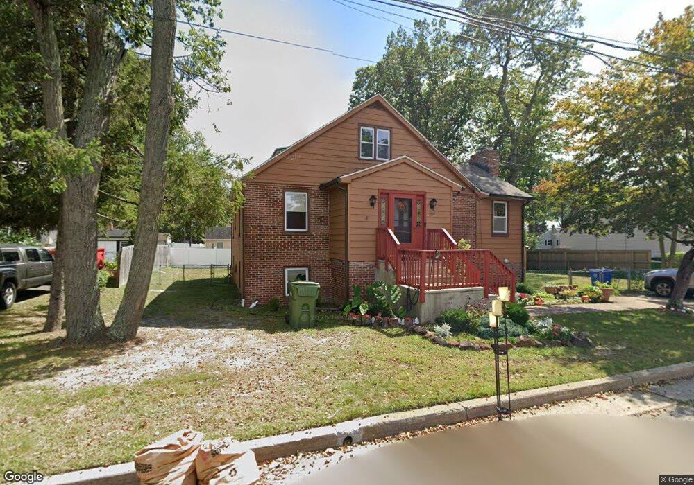
208 Paul Ave Eatontown, NJ 07724
Estimated Value: $651,000 - $764,000
2
Beds
3
Baths
2,012
Sq Ft
$348/Sq Ft
Est. Value
About This Home
This home is located at 208 Paul Ave, Eatontown, NJ 07724 and is currently estimated at $699,913, approximately $347 per square foot. 208 Paul Ave is a home located in Monmouth County with nearby schools including Woodmere Elementary School, Memorial Middle School, and Ranney School.
Ownership History
Date
Name
Owned For
Owner Type
Purchase Details
Closed on
Aug 25, 2009
Sold by
Kormann Victoria A
Bought by
Wain Barbara
Current Estimated Value
Home Financials for this Owner
Home Financials are based on the most recent Mortgage that was taken out on this home.
Original Mortgage
$240,000
Outstanding Balance
$156,800
Interest Rate
5.17%
Mortgage Type
New Conventional
Estimated Equity
$543,113
Create a Home Valuation Report for This Property
The Home Valuation Report is an in-depth analysis detailing your home's value as well as a comparison with similar homes in the area
Home Values in the Area
Average Home Value in this Area
Purchase History
| Date | Buyer | Sale Price | Title Company |
|---|---|---|---|
| Wain Barbara | $300,000 | Stewart Title Guaranty Co |
Source: Public Records
Mortgage History
| Date | Status | Borrower | Loan Amount |
|---|---|---|---|
| Open | Wain Barbara | $240,000 |
Source: Public Records
Tax History Compared to Growth
Tax History
| Year | Tax Paid | Tax Assessment Tax Assessment Total Assessment is a certain percentage of the fair market value that is determined by local assessors to be the total taxable value of land and additions on the property. | Land | Improvement |
|---|---|---|---|---|
| 2025 | $10,094 | $605,300 | $329,500 | $275,800 |
| 2024 | $8,994 | $539,200 | $279,000 | $260,200 |
| 2023 | $8,994 | $456,300 | $219,000 | $237,300 |
| 2022 | $7,525 | $392,300 | $194,500 | $197,800 |
| 2021 | $7,525 | $351,900 | $175,000 | $176,900 |
| 2020 | $7,905 | $346,700 | $175,000 | $171,700 |
| 2019 | $7,687 | $337,600 | $175,000 | $162,600 |
| 2018 | $7,589 | $328,400 | $175,000 | $153,400 |
| 2017 | $7,311 | $327,400 | $175,000 | $152,400 |
| 2016 | $6,842 | $313,400 | $160,000 | $153,400 |
| 2015 | $7,296 | $328,200 | $155,000 | $173,200 |
| 2014 | $6,964 | $308,700 | $155,000 | $153,700 |
Source: Public Records
Map
Nearby Homes
- 21 Walter Ave
- 14 Copperfield Ct
- 88 Windsor Dr
- 44 Charles Ct
- 217 Wyckoff Rd
- 36 Emma Place
- 139 Tanya Cir Unit 5506
- 19 Emma Place
- 102 Rolling Meadows Blvd S
- 17 Emma Place
- 106 Rolling Meadows Blvd S
- 119 Beacon Ln Unit 404
- 62 Rolling Meadows Blvd S
- 11 Rolling Meadows Blvd S
- 41 Rolling Meadows Blvd S
- 46 Fredric Dr
- 0 Pinebrook Rd
- 16 Rolling Meadows Blvd S
- 4 Magnolia Ct
- 49 Laurel Place Unit A