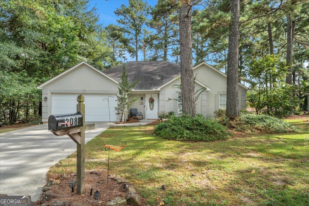
208 Pendleton Ct Macon, GA 31216
Estimated payment $1,429/month
Highlights
- Deck
- No HOA
- Tray Ceiling
- Vaulted Ceiling
- Cul-De-Sac
- Double Pane Windows
About This Home
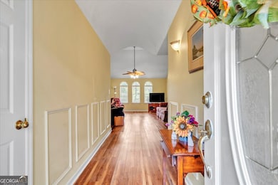
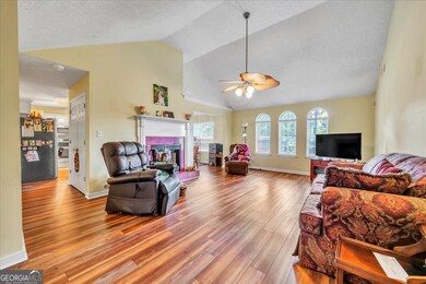
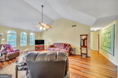
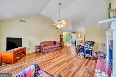
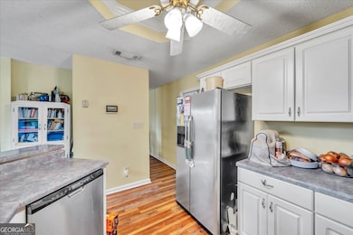
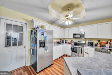
Welcome to this charming, one-level, 3 bed/2 bath home in South Bibb County featuring updated flooring throughout. The vaulted ceilings and semi-open floorplan add natural light and a more spacious feel. The kitchen features stainless steel appliances and a layout that flows seamlessly to the living and dining areas as well as the outdoors. There you will find a large deck built for entertaining and designed with the future addition of a pool in mind for our lengthy warm seasons! The fenced backyard provides privacy and room to play, while the convenient location places you just minutes from both Macon and Warner Robins. Enjoy the perfect blend of comfort and convenience.
Home Details
Home Type
- Single Family
Est. Annual Taxes
- $2,009
Year Built
- Built in 1995
Lot Details
- 0.56 Acre Lot
- Cul-De-Sac
- Back Yard Fenced
- Level Lot
Home Design
- Garden Home
- Slab Foundation
- Composition Roof
- Stucco
Interior Spaces
- 1,588 Sq Ft Home
- 1-Story Property
- Tray Ceiling
- Vaulted Ceiling
- Ceiling Fan
- Double Pane Windows
- Entrance Foyer
- Family Room with Fireplace
- Combination Dining and Living Room
- Vinyl Flooring
- Laundry closet
Kitchen
- Breakfast Bar
- Oven or Range
- Microwave
- Dishwasher
Bedrooms and Bathrooms
- 3 Main Level Bedrooms
- Walk-In Closet
- 2 Full Bathrooms
- Double Vanity
Parking
- Garage
- Garage Door Opener
Outdoor Features
- Deck
Schools
- Porter Elementary School
- Rutland Middle School
- Rutland High School
Utilities
- Central Heating and Cooling System
- Septic Tank
- High Speed Internet
- Cable TV Available
Community Details
- No Home Owners Association
- Rutland Station Subdivision
Map
Home Values in the Area
Average Home Value in this Area
Tax History
| Year | Tax Paid | Tax Assessment Tax Assessment Total Assessment is a certain percentage of the fair market value that is determined by local assessors to be the total taxable value of land and additions on the property. | Land | Improvement |
|---|---|---|---|---|
| 2025 | $1,650 | $81,744 | $12,000 | $69,744 |
| 2024 | $1,709 | $81,744 | $12,000 | $69,744 |
| 2023 | $1,146 | $70,120 | $12,000 | $58,120 |
| 2022 | $2,090 | $67,382 | $9,600 | $57,782 |
| 2021 | $1,734 | $52,628 | $8,000 | $44,628 |
| 2020 | $1,771 | $52,628 | $8,000 | $44,628 |
| 2019 | $1,786 | $52,628 | $8,000 | $44,628 |
| 2018 | $2,915 | $52,628 | $8,000 | $44,628 |
| 2017 | $1,833 | $55,923 | $9,600 | $46,323 |
| 2016 | $1,693 | $55,923 | $9,600 | $46,323 |
| 2015 | $2,396 | $55,923 | $9,600 | $46,323 |
| 2014 | $800 | $55,923 | $9,600 | $46,323 |
Property History
| Date | Event | Price | List to Sale | Price per Sq Ft |
|---|---|---|---|---|
| 11/02/2025 11/02/25 | Pending | -- | -- | -- |
| 10/21/2025 10/21/25 | For Sale | $239,900 | -- | $151 / Sq Ft |
Purchase History
| Date | Type | Sale Price | Title Company |
|---|---|---|---|
| Warranty Deed | $137,000 | None Available | |
| Warranty Deed | $128,000 | None Available |
Mortgage History
| Date | Status | Loan Amount | Loan Type |
|---|---|---|---|
| Open | $137,000 | Unknown | |
| Previous Owner | $128,000 | New Conventional |
Source: Georgia MLS
MLS Number: 10628523
APN: M120-0231
Disclaimer: Certain information contained herein is derived from information provided by parties other than Homes.com. All information provided is deemed reliable, but is not guaranteed to be accurate and should be independently verified.
![]() The data relating to real estate for sale on this web site comes in part from the Broker Reciprocity Program of Georgia MLS. Real estate listings held by brokerage firms other than Redfin are marked with the Broker Reciprocity logo and detailed information about them includes the name of the listing brokers. Information deemed reliable but not guaranteed. Copyright 2025 Georgia MLS. All rights reserved.
The data relating to real estate for sale on this web site comes in part from the Broker Reciprocity Program of Georgia MLS. Real estate listings held by brokerage firms other than Redfin are marked with the Broker Reciprocity logo and detailed information about them includes the name of the listing brokers. Information deemed reliable but not guaranteed. Copyright 2025 Georgia MLS. All rights reserved.
- 305 Bransford Ct
- 120 Bransford Dr
- 4285 Holly Hill Dr
- 423 Windsor Ct
- Crofton Plan at Highland Pointe
- Redland Plan at Highland Pointe
- Hanover Plan at Highland Pointe
- 6233 Skipperton Rd
- 204 Old Oak Rd
- 3988 Hartley Bridge Rd
- 180 Ridge Cir
- 1122 Alma Dr
- 3906 Hartley Bridge Rd
- 3824 Bobby Ct
- 113 Matt Dr
- 1062 Alma Dr
