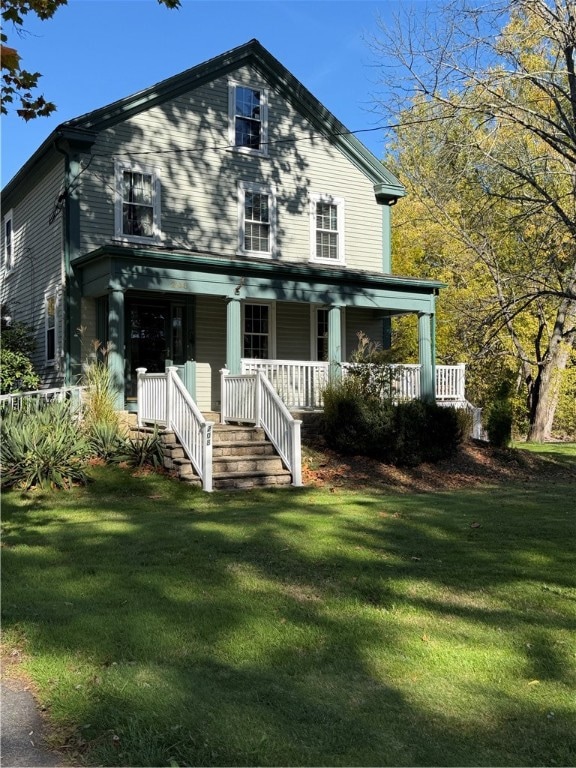


208 S Main St Raynham, MA 02767
Estimated payment $4,338/month
Highlights
- Golf Course Community
- Colonial Architecture
- Attic
- 2.74 Acre Lot
- Wood Flooring
- 4 Fireplaces
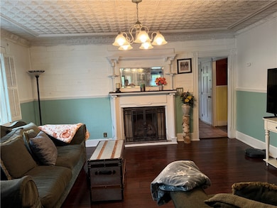
About This Home
This beautifully well preserved 3-bedroom, 2.5-bath home sits on 2.74 acres. The original character including elegant woodwork and details has been thoughtfully maintained while integrating a stunning, state-of-the-art kitchen. Perfect for the modern chef, this kitchen features high-end appliances, Corian countertops, and custom cabinetry. This unique property offers a warm welcoming living room with a beautiful fireplace leading into a family room, filled with natural light. A simple, yet elegant dining room and half bath complete the first floor. With two staircases leading to the second floor, three bedrooms and a full and half bath complete this level. An additional finished space on the third floor adds flexible living space for a studio, office or bedroom. This well appointed home awaits its new owner. Within walking distance to outdoor activities, parks, shopping, eateries and easy highway access.

Home Details
Home Type
- Single Family
Est. Annual Taxes
- $6,127
Year Built
- Built in 1832
Lot Details
- 2.74 Acre Lot
- Property is zoned R14
Parking
- 1 Car Detached Garage
Home Design
- Colonial Architecture
- Combination Foundation
- Clapboard
Interior Spaces
- 2,262 Sq Ft Home
- 3-Story Property
- 4 Fireplaces
- Gas Fireplace
- Thermal Windows
- Storm Doors
- Attic
Kitchen
- Oven
- Range
- Microwave
- Dishwasher
Flooring
- Wood
- Carpet
- Laminate
- Ceramic Tile
Bedrooms and Bathrooms
- 3 Bedrooms
- Bathtub with Shower
Laundry
- Dryer
- Washer
Unfinished Basement
- Basement Fills Entire Space Under The House
- Interior and Exterior Basement Entry
Outdoor Features
- Patio
- Porch
Location
- Property near a hospital
Utilities
- No Cooling
- Heating System Uses Oil
- Heating System Uses Steam
- 200+ Amp Service
- Electric Water Heater
Listing and Financial Details
- Tax Block 97
- Assessor Parcel Number 208SOUTHMAINSTRAYN
Community Details
Amenities
- Shops
- Restaurant
- Public Transportation
Recreation
- Golf Course Community
- Recreation Facilities
Map
Home Values in the Area
Average Home Value in this Area
Tax History
| Year | Tax Paid | Tax Assessment Tax Assessment Total Assessment is a certain percentage of the fair market value that is determined by local assessors to be the total taxable value of land and additions on the property. | Land | Improvement |
|---|---|---|---|---|
| 2025 | $6,415 | $530,200 | $233,700 | $296,500 |
| 2024 | $6,127 | $493,300 | $213,700 | $279,600 |
| 2023 | $5,896 | $433,500 | $191,700 | $241,800 |
| 2022 | $5,889 | $397,100 | $181,700 | $215,400 |
| 2021 | $0 | $387,100 | $171,700 | $215,400 |
| 2020 | $0 | $373,800 | $161,600 | $212,200 |
| 2019 | $5,177 | $363,800 | $151,600 | $212,200 |
| 2018 | $0 | $333,700 | $143,600 | $190,100 |
| 2017 | $4,784 | $318,300 | $137,600 | $180,700 |
| 2016 | $4,588 | $306,300 | $125,600 | $180,700 |
| 2015 | $3,726 | $244,500 | $124,900 | $119,600 |
Property History
| Date | Event | Price | List to Sale | Price per Sq Ft |
|---|---|---|---|---|
| 10/16/2025 10/16/25 | For Sale | $727,000 | -- | $321 / Sq Ft |
Purchase History
| Date | Type | Sale Price | Title Company |
|---|---|---|---|
| Deed | $350,000 | -- |
Mortgage History
| Date | Status | Loan Amount | Loan Type |
|---|---|---|---|
| Open | $207,500 | Purchase Money Mortgage |
Source: State-Wide MLS
MLS Number: 1397964
APN: RAYN-000014-000097
Disclaimer: Certain information contained herein is derived from information provided by parties other than Homes.com. All information provided is deemed reliable, but is not guaranteed to be accurate and should be independently verified.
![]() IDX information is provided exclusively for personal, non-commercial use, and may not be used for any purpose other than to identify prospective properties consumers may be interested in purchasing. Information is deemed reliable but not guaranteed.
IDX information is provided exclusively for personal, non-commercial use, and may not be used for any purpose other than to identify prospective properties consumers may be interested in purchasing. Information is deemed reliable but not guaranteed.
Copyright © 2025 State-Wide MLS, Inc. All rights reserved.
- 152 Forgeriver
- 0 S Main St Unit 73443212
- 215 Longmeadow Rd Unit 604
- 110 Dean St Unit 102
- 28 Barbara Rd
- 78 Arlington St Unit 2
- 78 Arlington St Unit 3
- 78 Arlington St Unit 1
- 55 Donna Terrace
- 37 Winter St
- 30 Buffington St
- 14 Wilbur St
- 13 Benefit St
- 26 Maynard St Unit A
- 11 Williams St
- 12 Chestnut St Unit A
- 6 Makepeace Ave
- 31 Church Green Unit 303
- 22 John St Unit 22
- 23 Johnson St Unit C
- 120 Dean St
- 172 N Main St
- 40 Purchase St Unit 1
- 43 Washburn St Unit 2
- 39 Union St Unit 1st Rear
- 39 Union St Unit 3rd
- 39 Union St Unit 6
- 22 Fruit St Unit 3
- 24 Union St Unit 3
- 20 Saint Mary's Square Unit 1
- 9 Fruit St Unit 2
- 9 Cedar St Unit 1R
- 19 Randall St Unit First Floor
- 66 Main St Unit 3A
- 173 Bay St Unit 3
- 240 High St
- 19 Spring St
- 56 W Weir St
- 52 Adams St Unit 3
- 1 Spring St