Estimated Value: $131,145 - $202,000
--
Bed
--
Bath
--
Sq Ft
3,305
Acres
About This Home
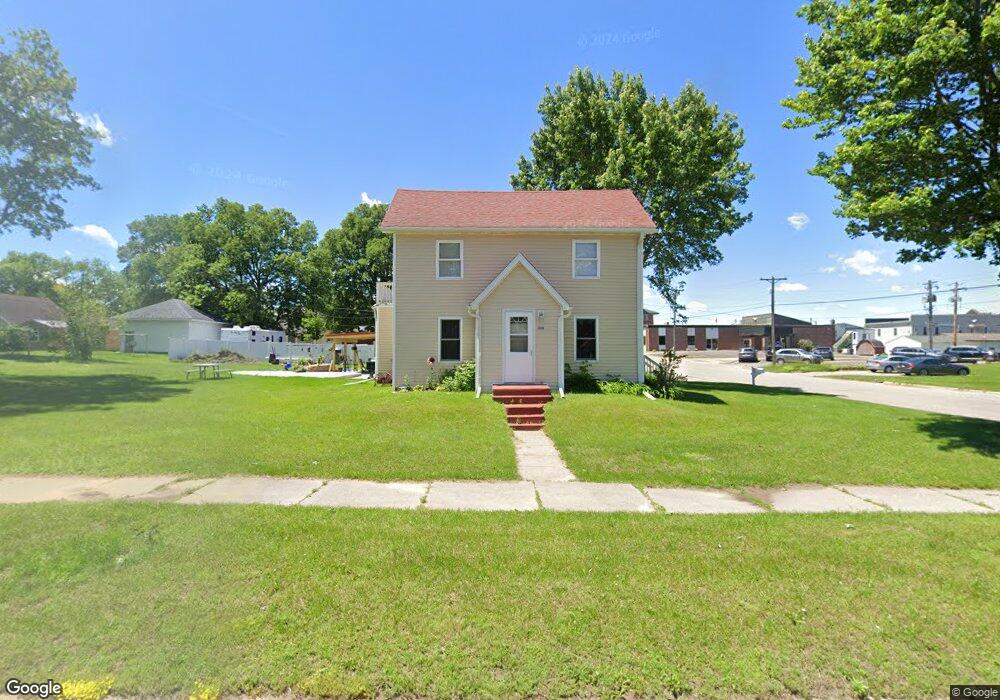
This home is located at 208 S Pearl St, Blair, WI 54616 and is currently estimated at $164,786. 208 S Pearl St is a home with nearby schools including Blair-Taylor Elementary School, Blair-Taylor Middle/High School, and Pinehill Amish School.
Ownership History
Date
Name
Owned For
Owner Type
Purchase Details
Closed on
Nov 18, 2022
Sold by
Kindschy Tab M and Kindschy Nancy R
Bought by
Hanson Thomas A and Hanson Kelley P
Current Estimated Value
Purchase Details
Closed on
May 27, 2006
Sold by
Matson Arland E and Drusch Joan K
Bought by
Matson Robert J and Upham Betty L
Home Financials for this Owner
Home Financials are based on the most recent Mortgage that was taken out on this home.
Original Mortgage
$49,600
Interest Rate
6.66%
Mortgage Type
Future Advance Clause Open End Mortgage
Create a Home Valuation Report for This Property
The Home Valuation Report is an in-depth analysis detailing your home's value as well as a comparison with similar homes in the area
Home Values in the Area
Average Home Value in this Area
Purchase History
| Date | Buyer | Sale Price | Title Company |
|---|---|---|---|
| Hanson Thomas A | $100,000 | Sandi Jo Stanek | |
| Matson Robert J | $62,000 | None Available |
Source: Public Records
Mortgage History
| Date | Status | Borrower | Loan Amount |
|---|---|---|---|
| Previous Owner | Matson Robert J | $49,600 |
Source: Public Records
Tax History Compared to Growth
Tax History
| Year | Tax Paid | Tax Assessment Tax Assessment Total Assessment is a certain percentage of the fair market value that is determined by local assessors to be the total taxable value of land and additions on the property. | Land | Improvement |
|---|---|---|---|---|
| 2024 | $2,222 | $145,500 | $10,200 | $135,300 |
| 2023 | $2,100 | $83,800 | $13,100 | $70,700 |
| 2022 | $2,254 | $83,800 | $13,100 | $70,700 |
| 2021 | $1,943 | $83,800 | $13,100 | $70,700 |
| 2020 | $1,864 | $20,170 | $13,100 | $7,070 |
| 2019 | $1,966 | $83,800 | $13,100 | $70,700 |
| 2018 | $1,706 | $83,800 | $13,100 | $70,700 |
| 2017 | $1,750 | $83,800 | $13,100 | $70,700 |
| 2016 | $1,615 | $83,800 | $13,100 | $70,700 |
| 2015 | $1,910 | $83,800 | $13,100 | $70,700 |
| 2014 | $1,779 | $83,800 | $13,100 | $70,700 |
| 2011 | $1,969 | $85,800 | $9,500 | $76,300 |
Source: Public Records
Map
Nearby Homes
- 127 E Broadway St
- 102 S Peterson Ave
- 328 S Urberg Ave
- 517 W Broadway St
- 313 S Park Rd
- 612 E Broadway St
- N34701 County Rd S
- N28881 County Rd S
- N34701 County Rd N
- N34855 County Rd S
- XX Vold Rd
- N32838 Briten Rd
- N27146 County Rd S
- N27046 County Rd S
- 00 Joe Coulee Rd
- W19292 Wisconsin 95
- 341 2nd St
- N30732 Square Bluff Rd
- 21 Hanson St
- 451 2nd St
- 205 S Pearl St
- 216 S Pearl St
- 102 S Pearl St
- 102 W 2nd St
- 119 S Pearl St
- 112 W 2nd St
- 211 S Urberg Ave
- 101 W Broadway St
- 219 Urberg Ave
- 103 E 2nd St
- 119 W 2nd St
- 123 W Broadway St
- 121 W Broadway St
- 226 E Broadway St
- 119 E 2nd St
- 125 S Pearl St
- 405 S Pearl St
- 215 E Broadway St
- 310 E Broadway St
- 318 E Broadway St