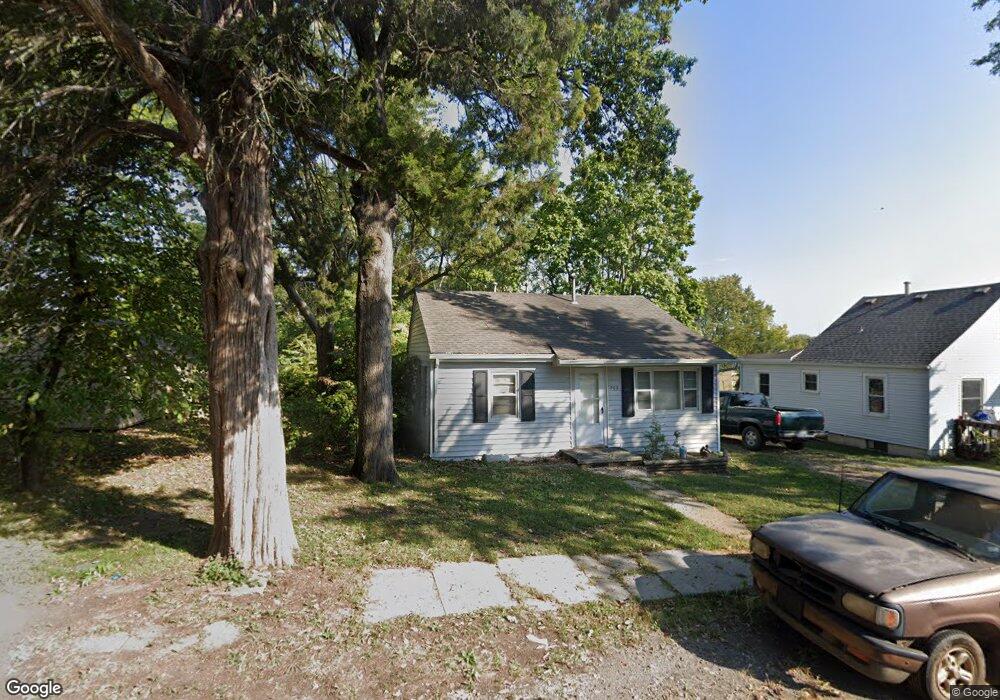
208 SW 13th St Oak Grove, MO 64075
Estimated Value: $141,563 - $181,000
2
Beds
1
Bath
756
Sq Ft
$222/Sq Ft
Est. Value
About This Home
This home is located at 208 SW 13th St, Oak Grove, MO 64075 and is currently estimated at $168,141, approximately $222 per square foot. 208 SW 13th St is a home located in Jackson County with nearby schools including Oak Grove Primary School, Oak Grove Elementary School, and Oak Grove Middle School.
Ownership History
Date
Name
Owned For
Owner Type
Purchase Details
Closed on
May 13, 2019
Sold by
Alewine Rodney P and Alewine Kari E
Bought by
Hudson Investments Llc
Current Estimated Value
Purchase Details
Closed on
May 2, 2019
Sold by
Marriott Oren R and Marriott Judy
Bought by
Alewine Rodney P and Alewine Kari E
Purchase Details
Closed on
Jun 7, 2018
Sold by
Ale Wine Rodney P and Ale Wine Kari E
Bought by
Marriott Ioren R
Purchase Details
Closed on
Sep 16, 2002
Sold by
Alewine Paul Lewis and Alewine Elizabeth Sue
Bought by
Alewine Rodney P and Alewine Kari E
Create a Home Valuation Report for This Property
The Home Valuation Report is an in-depth analysis detailing your home's value as well as a comparison with similar homes in the area
Home Values in the Area
Average Home Value in this Area
Purchase History
| Date | Buyer | Sale Price | Title Company |
|---|---|---|---|
| Hudson Investments Llc | -- | Kansas City Title Inc | |
| Alewine Rodney P | -- | None Available | |
| Marriott Ioren R | -- | None Available | |
| Alewine Rodney P | -- | -- |
Source: Public Records
Tax History Compared to Growth
Tax History
| Year | Tax Paid | Tax Assessment Tax Assessment Total Assessment is a certain percentage of the fair market value that is determined by local assessors to be the total taxable value of land and additions on the property. | Land | Improvement |
|---|---|---|---|---|
| 2025 | $1,135 | $15,077 | $6,481 | $8,596 |
| 2024 | $1,124 | $14,611 | $3,135 | $11,476 |
| 2023 | $1,124 | $14,611 | $3,135 | $11,476 |
| 2022 | $961 | $11,400 | $2,385 | $9,015 |
| 2021 | $940 | $11,400 | $2,385 | $9,015 |
| 2020 | $853 | $10,073 | $2,385 | $7,688 |
| 2019 | $1,111 | $13,802 | $2,385 | $11,417 |
| 2018 | $773 | $10,073 | $1,577 | $8,496 |
| 2017 | $693 | $10,073 | $1,577 | $8,496 |
| 2016 | $693 | $8,759 | $893 | $7,866 |
| 2014 | $597 | $7,518 | $1,243 | $6,275 |
Source: Public Records
Map
Nearby Homes
- 1705 Locust St
- 1312 SW Clinton St
- 704 SW Clinton St
- 1501 SW Stonewall Dr
- 1700 SW Stonewall Dr
- 1606 SW Stonewall Dr
- 303 SW 17th St
- 508 SE 12th St
- 1807 SW Cemetery Rd
- TBD SW 5th St
- 1108 SE Oak Ridge Dr
- 202 SW 21st St
- 801 SE 13th St
- 1106 SE Chelsey Ln
- 509 SE 20th St
- 1106 SW 10th St
- 1212 SW 5th St
- 612 SE 21st St
- 701 SE 21st St
- 2112 SE Oak Ridge Dr
- 206 SW 13th St
- 1201 SW Mitchell St
- 204 SW 13th St
- 209 SW 12th St
- 202 SW 13th St
- 205 SW 12th St
- 300 SW 13th St
- 203 SW 12th St
- 1300 SW Mitchell St
- 200 SW 13th St
- 1202 SW No Address Assigned By City St
- 301 SW 12th St
- 1303 SW Mitchell St
- 301 SW 13th St
- 302 SW 13th St
- 303 SW 13th St
- 304 SW 13th St
- 1305 SW Mitchell St
- 1304 SW Mitchell St
- 108 SW 13th St