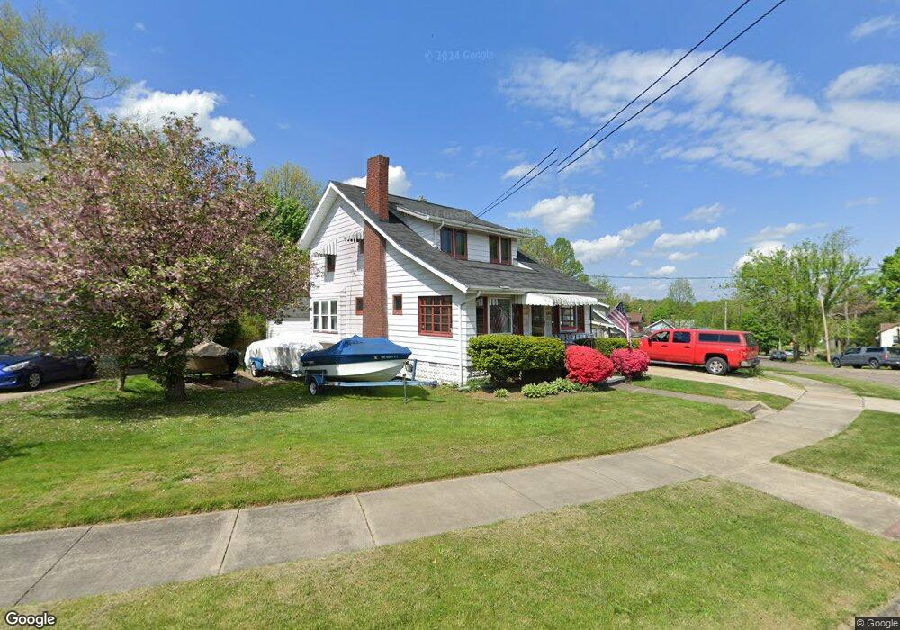
208 the Brooklands Akron, OH 44305
Goodyear Heights NeighborhoodEstimated Value: $114,000 - $143,000
2
Beds
1
Bath
1,586
Sq Ft
$82/Sq Ft
Est. Value
About This Home
This home is located at 208 the Brooklands, Akron, OH 44305 and is currently estimated at $129,821, approximately $81 per square foot. 208 the Brooklands is a home located in Summit County with nearby schools including Seiberling Community Learning Center, Akron Preparatory school, and Middlebury Academy.
Ownership History
Date
Name
Owned For
Owner Type
Purchase Details
Closed on
Nov 9, 2020
Sold by
Christyne Mullins
Bought by
Hirsch Matthew
Current Estimated Value
Purchase Details
Closed on
Nov 4, 2020
Sold by
Christyne Mullins
Bought by
Hirsch Matthew
Purchase Details
Closed on
Jul 12, 2007
Sold by
Urdiales Maryelva
Bought by
Mullins Christyne
Create a Home Valuation Report for This Property
The Home Valuation Report is an in-depth analysis detailing your home's value as well as a comparison with similar homes in the area
Home Values in the Area
Average Home Value in this Area
Purchase History
| Date | Buyer | Sale Price | Title Company |
|---|---|---|---|
| Hirsch Matthew | $67,500 | Mullins Christyne | |
| Hirsch Matthew | $67,500 | Mullins Christyne | |
| Mullins Christyne | -- | Accommodation |
Source: Public Records
Tax History
| Year | Tax Paid | Tax Assessment Tax Assessment Total Assessment is a certain percentage of the fair market value that is determined by local assessors to be the total taxable value of land and additions on the property. | Land | Improvement |
|---|---|---|---|---|
| 2025 | $2,316 | $34,084 | $10,028 | $24,056 |
| 2024 | $1,996 | $34,084 | $10,028 | $24,056 |
| 2023 | $1,996 | $34,084 | $10,028 | $24,056 |
| 2022 | $1,852 | $24,581 | $7,112 | $17,469 |
| 2021 | $1,853 | $24,581 | $7,112 | $17,469 |
| 2020 | $1,872 | $24,580 | $7,110 | $17,470 |
| 2019 | $1,964 | $23,600 | $7,610 | $15,990 |
| 2018 | $1,888 | $23,600 | $7,610 | $15,990 |
| 2017 | $1,916 | $23,600 | $7,610 | $15,990 |
| 2016 | $1,918 | $23,600 | $7,610 | $15,990 |
| 2015 | $1,916 | $23,600 | $7,610 | $15,990 |
| 2014 | $1,902 | $23,600 | $7,610 | $15,990 |
| 2013 | $2,011 | $25,650 | $7,610 | $18,040 |
Source: Public Records
Map
Nearby Homes
- 248 Malacca St
- 1837 Marks Ave
- 295 Goodview Ave
- 1874 Adelaide Blvd
- 1991-1993 Congo St
- 1604 Hampton Rd
- 1726 Shaw Ave
- 20 Verdun Dr
- 439 Larkin Ave
- 1581 Hillside Terrace
- 1551 Preston Ave
- 465 Saint Leger Ave
- 1578 Pilgrim St
- 2258 Mogadore Rd
- 110 Eastholm Ave
- 2269 Emerald Dr
- 111 Akers Ave
- 153 Cutler Pkwy
- 167 Pioneer St
- 1442 Hillside Terrace
- 200 the Brooklands
- 1834 Malasia Rd
- 192 the Brooklands
- 1856 Malasia Rd
- 197 the Brooklands
- 1824 Malasia Rd
- 1855 Malasia Rd
- 186 the Brooklands
- 191 the Brooklands
- 226 the Brooklands
- 219 the Brooklands
- 1820 Malasia Rd
- 1835 Java Ave
- 1864 Malasia Rd
- 225 the Brooklands
- 1863 Malasia Rd
- 1805 Preston Ave
- 1805 Preston Ave
- 1805 Preston Ave
- 1805 Preston Ave
Your Personal Tour Guide
Ask me questions while you tour the home.