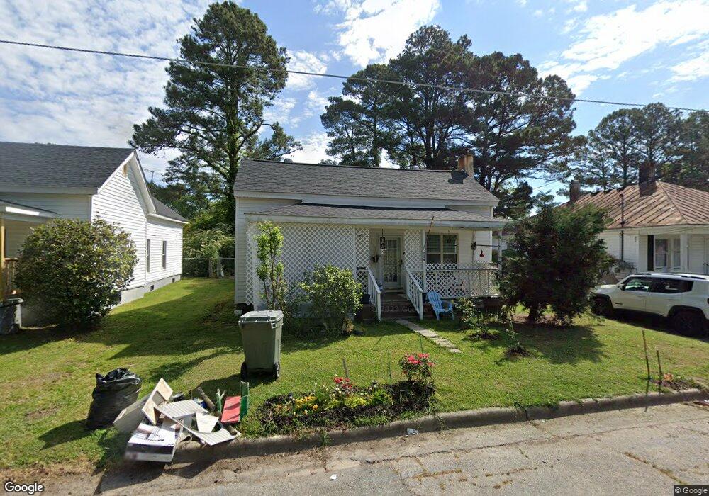
208 W Thompson Ave Stantonsburg, NC 27883
Estimated Value: $110,462 - $185,000
2
Beds
1
Bath
1,055
Sq Ft
$126/Sq Ft
Est. Value
About This Home
This home is located at 208 W Thompson Ave, Stantonsburg, NC 27883 and is currently estimated at $132,866, approximately $125 per square foot. 208 W Thompson Ave is a home located in Wilson County with nearby schools including Beddingfield High School, Stantonsburg Elementary School, and Speight Middle School.
Ownership History
Date
Name
Owned For
Owner Type
Purchase Details
Closed on
Jan 7, 2017
Sold by
Armstrong Robert E and Armstrong Patricia W
Bought by
Gorostiaga Dina and Yaravide Claudio
Current Estimated Value
Purchase Details
Closed on
Jun 28, 2006
Sold by
Deans Margie Lee
Bought by
Armstrong Robert E
Home Financials for this Owner
Home Financials are based on the most recent Mortgage that was taken out on this home.
Original Mortgage
$20,250
Interest Rate
6.6%
Mortgage Type
Future Advance Clause Open End Mortgage
Create a Home Valuation Report for This Property
The Home Valuation Report is an in-depth analysis detailing your home's value as well as a comparison with similar homes in the area
Home Values in the Area
Average Home Value in this Area
Purchase History
| Date | Buyer | Sale Price | Title Company |
|---|---|---|---|
| Gorostiaga Dina | $11,000 | None Available | |
| Armstrong Robert E | $22,500 | -- |
Source: Public Records
Mortgage History
| Date | Status | Borrower | Loan Amount |
|---|---|---|---|
| Previous Owner | Armstrong Robert E | $20,250 |
Source: Public Records
Tax History Compared to Growth
Tax History
| Year | Tax Paid | Tax Assessment Tax Assessment Total Assessment is a certain percentage of the fair market value that is determined by local assessors to be the total taxable value of land and additions on the property. | Land | Improvement |
|---|---|---|---|---|
| 2025 | $855 | $71,570 | $20,000 | $51,570 |
| 2024 | $855 | $71,570 | $20,000 | $51,570 |
| 2023 | $439 | $32,972 | $14,000 | $18,972 |
| 2022 | $406 | $32,972 | $14,000 | $18,972 |
| 2021 | $406 | $32,972 | $14,000 | $18,972 |
| 2020 | $406 | $32,972 | $14,000 | $18,972 |
| 2019 | $406 | $32,972 | $14,000 | $18,972 |
| 2018 | $406 | $32,972 | $14,000 | $18,972 |
| 2017 | $241 | $32,972 | $14,000 | $18,972 |
| 2016 | $241 | $32,972 | $14,000 | $18,972 |
| 2014 | $235 | $32,177 | $14,000 | $18,177 |
Source: Public Records
Map
Nearby Homes
- 304 W Thompson Ave
- 302 N Saratoga St
- 304 Minshall Dr
- 6243 N Carolina 58
- 7629 Sand Pit Rd
- 1230 Middlecrest Dr
- DUPONT Plan at Briar Farm
- ESSEX Plan at Briar Farm
- AUBURN Plan at Briar Farm
- 7752 Sand Pit Rd
- 7768 Sand Pit Rd
- 7770 Sand Pit Rd
- 831 Parris Rd
- 0 Parris Rd Unit LotWP001 24681582
- 865 Old Mill Rd
- 1078 Aycock Rd
- 8714 Tyson Farm Rd
- 229 Old Mill Rd
- 4622 Evansdale Rd
- 6756 E Main St
- 210 W Thompson Ave
- 206 W Thompson Ave
- 204 W Thompson Ave
- 203 W Thompson Ave
- 202 W Thompson Ave
- 104 S Whitley St
- 103 S Whitley St
- 102 S Whitley St
- 200 E Thompson Ave
- 200 S Yelverton St
- 205 E Commercial Ave
- 102 S Yelverton St
- 202 S Yelverton St
- 207 W Commercial Ave
- 301 W Commercial Ave
- 201 W Commercial Ave
- 303 Commercial Ave
- 303 Commercial Ave
- 103 S Yelverton St
- lot S Yelverton St