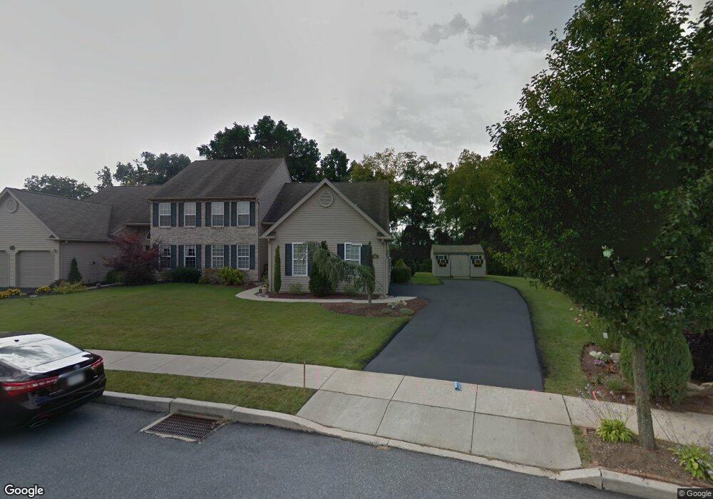
2081 Rolling Meadow Dr Macungie, PA 18062
Lower Macungie Township East NeighborhoodEstimated Value: $468,000 - $556,000
3
Beds
3
Baths
2,438
Sq Ft
$216/Sq Ft
Est. Value
About This Home
This home is located at 2081 Rolling Meadow Dr, Macungie, PA 18062 and is currently estimated at $525,469, approximately $215 per square foot. 2081 Rolling Meadow Dr is a home located in Lehigh County with nearby schools including Willow Lane Elementary School, Eyer Middle School, and Emmaus High School.
Ownership History
Date
Name
Owned For
Owner Type
Purchase Details
Closed on
Apr 10, 2007
Sold by
K & M Developers Inc
Bought by
Barth Charles J
Current Estimated Value
Home Financials for this Owner
Home Financials are based on the most recent Mortgage that was taken out on this home.
Original Mortgage
$110,000
Outstanding Balance
$66,838
Interest Rate
6.24%
Mortgage Type
New Conventional
Estimated Equity
$458,631
Create a Home Valuation Report for This Property
The Home Valuation Report is an in-depth analysis detailing your home's value as well as a comparison with similar homes in the area
Home Values in the Area
Average Home Value in this Area
Purchase History
| Date | Buyer | Sale Price | Title Company |
|---|---|---|---|
| Barth Charles J | $319,780 | -- |
Source: Public Records
Mortgage History
| Date | Status | Borrower | Loan Amount |
|---|---|---|---|
| Open | Barth Charles J | $110,000 |
Source: Public Records
Tax History Compared to Growth
Tax History
| Year | Tax Paid | Tax Assessment Tax Assessment Total Assessment is a certain percentage of the fair market value that is determined by local assessors to be the total taxable value of land and additions on the property. | Land | Improvement |
|---|---|---|---|---|
| 2025 | $7,087 | $277,600 | $42,600 | $235,000 |
| 2024 | $6,857 | $277,600 | $42,600 | $235,000 |
| 2023 | $6,720 | $277,600 | $42,600 | $235,000 |
| 2022 | $6,561 | $277,600 | $235,000 | $42,600 |
| 2021 | $6,174 | $266,900 | $42,600 | $224,300 |
| 2020 | $6,115 | $266,900 | $42,600 | $224,300 |
| 2019 | $6,011 | $266,900 | $42,600 | $224,300 |
| 2018 | $5,932 | $266,900 | $42,600 | $224,300 |
| 2017 | $5,828 | $266,900 | $42,600 | $224,300 |
| 2016 | -- | $266,900 | $42,600 | $224,300 |
| 2015 | -- | $282,200 | $42,600 | $239,600 |
| 2014 | -- | $251,600 | $42,600 | $209,000 |
Source: Public Records
Map
Nearby Homes
- 2073 Rolling Meadow Dr
- 6115 Timberknoll Dr
- 2154 Gorton Rd
- 6022 Eli Cir
- 6007 Timberknoll Dr
- 1795 Willow Ln
- 1991 Autumn Ridge Rd
- 1597 Cambridge Dr
- 1536 Cambridge Dr
- 2362 S Pewter Dr
- 2611 Fieldview Dr
- 5804 Burning Tree Ln
- 2593 Old Wagon Ct
- 2771 Rolling Green Place Unit C419
- 2225 Four Seasons Blvd Unit 116A0
- 6179 Fairway Ln
- 6563 Lower MacUngie Rd
- 6528 Carmel Dr
- 5706 Whitemarsh Dr
- 2173 Brookside Rd
- 2083 Rolling Meadow Dr
- 2077 Rolling Meadow Dr
- 2087 Rolling Meadow Dr
- 2074 Rolling Meadow Dr
- 2069 Rolling Meadow Dr
- 2035 Mill Creek Rd
- 2091 Rolling Meadow Dr
- 2078 Rolling Meadow Dr
- 2070 Rolling Meadow Dr
- 2065 Rolling Meadow Dr
- 2066 Rolling Meadow Dr
- 2055 Mill Creek Rd
- 2061 Rolling Meadow Dr
- 2082 Rolling Meadow Dr
- 2062 Rolling Meadow Dr
- 2005 Mill Creek Rd
- 2057 Rolling Meadow Dr
- 2058 Rolling Meadow Dr
- 2053 Rolling Meadow Dr
- 2099 Rolling Meadow Dr