
Seller's Agent in 2025
Wilson Lahoud
Inca Realty, LLC
(810) 691-1485
6 in this area
108 Total Sales
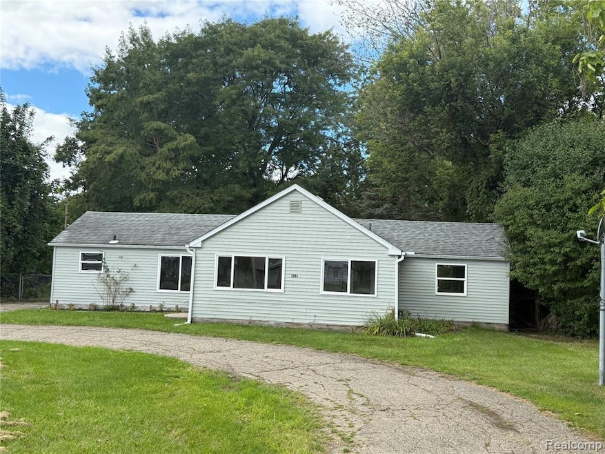
DEMAND LOCATION!! Charming ranch w/ 3 bedrooms 2 full bath, completely updated with new drywall through out. Newly Updates include; roof, shingles siding, windows. New floor coverings, kitchen and 2 full bathrooms, freshly painted interior, new kitchen counter-tops & exterior doors. A must see! Good size back yard and shed.
Last Agent to Sell the Property
Inca Realty, LLC License #6501303462 Listed on: 08/29/2025
| Date | Type | Sale Price | Title Company |
|---|---|---|---|
| Warranty Deed | $145,000 | Cislo Title Company | |
| Warranty Deed | $65,000 | Cislo Title Company | |
| Contract Of Sale | -- | None Listed On Document | |
| Quit Claim Deed | -- | Sky Title Agency | |
| Quit Claim Deed | -- | Sky Title Agency | |
| Land Contract | -- | Metropolitan Title Company | |
| Quit Claim Deed | -- | Lawyers Title Insurance Corp | |
| Corporate Deed | $36,000 | Sargents Title | |
| Quit Claim Deed | -- | -- | |
| Sheriffs Deed | $41,000 | -- |
| Date | Status | Loan Amount | Loan Type |
|---|---|---|---|
| Open | $142,373 | FHA |
| Date | Event | Price | List to Sale | Price per Sq Ft |
|---|---|---|---|---|
| 11/14/2025 11/14/25 | Sold | $145,000 | +5.8% | $112 / Sq Ft |
| 11/03/2025 11/03/25 | Pending | -- | -- | -- |
| 10/14/2025 10/14/25 | Price Changed | $137,000 | -5.5% | $105 / Sq Ft |
| 08/29/2025 08/29/25 | For Sale | $144,900 | -- | $111 / Sq Ft |
| Year | Tax Paid | Tax Assessment Tax Assessment Total Assessment is a certain percentage of the fair market value that is determined by local assessors to be the total taxable value of land and additions on the property. | Land | Improvement |
|---|---|---|---|---|
| 2025 | $3,822 | $63,300 | $0 | $0 |
| 2024 | $2,569 | $63,300 | $0 | $0 |
| 2023 | $1,054 | $50,200 | $0 | $0 |
| 2022 | $564 | $40,900 | $0 | $0 |
| 2021 | $553 | $36,400 | $0 | $0 |
| 2020 | $952 | $30,000 | $0 | $0 |
| 2019 | $940 | $29,800 | $0 | $0 |
| 2018 | $1,439 | $23,200 | $0 | $0 |
| 2017 | $1,389 | $23,200 | $0 | $0 |
| 2016 | $1,407 | $22,800 | $0 | $0 |
| 2015 | $1,272 | $22,800 | $0 | $0 |
| 2014 | $910 | $21,900 | $0 | $0 |
| 2012 | -- | $24,000 | $24,000 | $0 |
Seller's Agent in 2025
Wilson Lahoud
Inca Realty, LLC
(810) 691-1485
6 in this area
108 Total Sales
Buyer's Agent in 2025
Amy Golombeski
Mitten Life Realty
(810) 449-2256
1 in this area
55 Total Sales
Source: Realcomp
MLS Number: 20251031943
APN: 07-20-100-021
Disclaimer: Certain information contained herein is derived from information provided by parties other than Homes.com. All information provided is deemed reliable, but is not guaranteed to be accurate and should be independently verified.
![]() IDX provided courtesy of Realcomp II Ltd. via Ten-X and MLS
IDX provided courtesy of Realcomp II Ltd. via Ten-X and MLS
Copyright 2026 Realcomp II Ltd. Shareholders
IDX information is provided exclusively for consumers' personal, noncommercial use and may not be used for any purpose other than to identify prospective properties consumers may be interested in purchasing. The accuracy of all information, regardless of source, is not guaranteed or warranted. All information should be independently verified.
Listing Information presented by local MLS brokerage: Ten-X, local REALTOR®- Arlene Richardson - (888)-952-6393
Ask me questions while you tour the home.