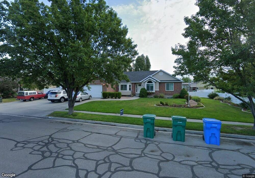
2084 Silver Tree Cir Riverton, UT 84065
Estimated Value: $676,000 - $787,000
3
Beds
3
Baths
1,922
Sq Ft
$380/Sq Ft
Est. Value
About This Home
This home is located at 2084 Silver Tree Cir, Riverton, UT 84065 and is currently estimated at $731,101, approximately $380 per square foot. 2084 Silver Tree Cir is a home located in Salt Lake County with nearby schools including Rosamond Elementary School, Oquirrh Hills Middle School, and Riverton High School.
Ownership History
Date
Name
Owned For
Owner Type
Purchase Details
Closed on
Oct 1, 2003
Sold by
Solomon Michael R and Solomon Kelli P
Bought by
Maxfield Russell J and Maxfield Brittany H
Current Estimated Value
Home Financials for this Owner
Home Financials are based on the most recent Mortgage that was taken out on this home.
Original Mortgage
$206,550
Outstanding Balance
$96,455
Interest Rate
6.22%
Mortgage Type
Unknown
Estimated Equity
$634,646
Purchase Details
Closed on
May 26, 1999
Sold by
D A F Ltd Partnership
Bought by
Solomon Michael R and Solomon Kelli P
Home Financials for this Owner
Home Financials are based on the most recent Mortgage that was taken out on this home.
Original Mortgage
$210,000
Interest Rate
6.86%
Purchase Details
Closed on
Sep 25, 1996
Sold by
Lane Myers Construction Inc
Bought by
Rindlisbacher Shon D
Create a Home Valuation Report for This Property
The Home Valuation Report is an in-depth analysis detailing your home's value as well as a comparison with similar homes in the area
Home Values in the Area
Average Home Value in this Area
Purchase History
| Date | Buyer | Sale Price | Title Company |
|---|---|---|---|
| Maxfield Russell J | -- | Title West | |
| Solomon Michael R | -- | Security Title Ins Agency | |
| D A F Ltd Partnership | -- | Security Title Ins Agency | |
| Rindlisbacher Shon D | -- | -- |
Source: Public Records
Mortgage History
| Date | Status | Borrower | Loan Amount |
|---|---|---|---|
| Open | Maxfield Russell J | $206,550 | |
| Previous Owner | Solomon Michael R | $210,000 |
Source: Public Records
Tax History
| Year | Tax Paid | Tax Assessment Tax Assessment Total Assessment is a certain percentage of the fair market value that is determined by local assessors to be the total taxable value of land and additions on the property. | Land | Improvement |
|---|---|---|---|---|
| 2025 | $3,839 | $683,500 | $282,300 | $401,200 |
| 2024 | $3,839 | $664,500 | $274,200 | $390,300 |
| 2023 | $3,914 | $638,600 | $268,900 | $369,700 |
| 2022 | $4,065 | $650,600 | $263,600 | $387,000 |
| 2021 | $3,499 | $498,600 | $223,500 | $275,100 |
| 2020 | $3,348 | $444,800 | $222,300 | $222,500 |
| 2019 | $3,310 | $432,400 | $218,900 | $213,500 |
| 2017 | $3,031 | $379,900 | $145,900 | $234,000 |
| 2016 | $2,914 | $350,400 | $145,900 | $204,500 |
Source: Public Records
Map
Nearby Homes
- 2127 Silver Tree Cir
- 1719 W 12050 S
- 12317 S Redwood Rd
- 12325 S Redwood Rd
- 1661 W Madison View Dr
- 12341 S Redwood Rd
- 1644 W Madison Ridge Ln
- 2356 W Montcalm Dr
- 1733 W Shade Ln
- 2329 W Myers Ln
- 1721 W Hollow Cedar Ln Unit 1
- 1924 W Trail Heights Dr
- 11788 S Myers Park Ln Unit 101
- 1056 W Kate Springs Ln S Unit 10
- 12501 Falls Creek Rd
- 12702 S City Heights Dr Unit 158
- 12332 S 2700 W
- 11718 S Myers Park Ln Unit 105
- 11710 S Myers Park Ln Unit 106
- 1612 W Maple Brook Ln Unit 27
- 2104 Silver Tree Cir
- 2104 W Silver Tree Cir
- 2062 Silver Tree Cir
- 2073 W 12190 S
- 2105 W 12190 S
- 2057 W 12190 S
- 12239 S 2090 W
- 12236 S 2090 W
- 12236 S 2090 W
- 2107 Silver Tree Cir
- 2126 Silver Tree Cir
- 2042 W Silver Tree Cir
- 2042 Silver Tree Cir
- 12238 Grassland Ct
- 12238 S Grassland Ct
- 2041 W 12190 S
- 2074 W 12190 S
- 2090 W 12190 S
- 2131 W 12190 S
- 2058 W 12190 S
Your Personal Tour Guide
Ask me questions while you tour the home.