Estimated Value: $147,000 - $173,000
3
Beds
2
Baths
1,700
Sq Ft
$93/Sq Ft
Est. Value
About This Home
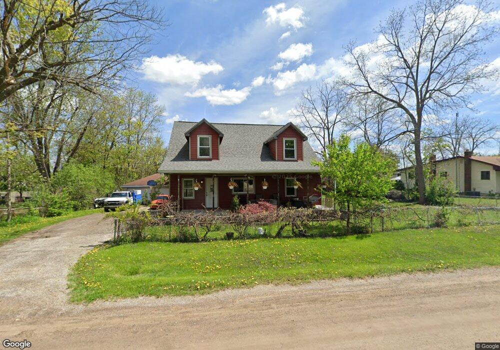
This home is located at 2085 Diamond Ave, Flint, MI 48532 and is currently estimated at $157,296, approximately $92 per square foot. 2085 Diamond Ave is a home located in Genesee County with nearby schools including Carman-Ainsworth High School, Genesee STEM Academy, and St. Paul Lutheran School.
Ownership History
Date
Name
Owned For
Owner Type
Purchase Details
Closed on
Feb 20, 2019
Sold by
Pelky Timothy L and Mead Audrianne
Bought by
Pelky Timothy L and Mead Audrianne
Current Estimated Value
Home Financials for this Owner
Home Financials are based on the most recent Mortgage that was taken out on this home.
Original Mortgage
$16,000
Interest Rate
4.4%
Mortgage Type
New Conventional
Purchase Details
Closed on
Nov 7, 2001
Sold by
Dover Julianne and Mead Julianne
Bought by
Pelky Timothy L and Mead Audrianne
Home Financials for this Owner
Home Financials are based on the most recent Mortgage that was taken out on this home.
Original Mortgage
$44,000
Interest Rate
6.69%
Create a Home Valuation Report for This Property
The Home Valuation Report is an in-depth analysis detailing your home's value as well as a comparison with similar homes in the area
Home Values in the Area
Average Home Value in this Area
Purchase History
| Date | Buyer | Sale Price | Title Company |
|---|---|---|---|
| Pelky Timothy L | -- | None Available | |
| Pelky Timothy L | $55,000 | Centennial Title & Abstract |
Source: Public Records
Mortgage History
| Date | Status | Borrower | Loan Amount |
|---|---|---|---|
| Closed | Pelky Timothy L | $16,000 | |
| Closed | Pelky Timothy L | $44,000 |
Source: Public Records
Tax History
| Year | Tax Paid | Tax Assessment Tax Assessment Total Assessment is a certain percentage of the fair market value that is determined by local assessors to be the total taxable value of land and additions on the property. | Land | Improvement |
|---|---|---|---|---|
| 2025 | $2,323 | $74,900 | $0 | $0 |
| 2024 | $1,140 | $66,600 | $0 | $0 |
| 2023 | $1,062 | $54,000 | $0 | $0 |
| 2022 | $1,056 | $48,800 | $0 | $0 |
| 2021 | $1,941 | $45,100 | $0 | $0 |
| 2020 | $942 | $37,800 | $0 | $0 |
| 2019 | $932 | $32,000 | $0 | $0 |
| 2018 | $1,997 | $39,700 | $0 | $0 |
| 2017 | $2,165 | $39,700 | $0 | $0 |
| 2016 | $1,989 | $35,800 | $0 | $0 |
| 2015 | $1,331 | $34,700 | $0 | $0 |
| 2014 | $790 | $33,100 | $0 | $0 |
| 2012 | -- | $38,700 | $38,700 | $0 |
Source: Public Records
Map
Nearby Homes
- 18.41 Taft Rd
- 2033 Eberly Rd
- 10 Acres T A Mansour Blvd
- 1512 Crescent Lane Dr Lot#46
- 4474 Corunna Rd
- 4480 Corunna Rd
- 1455 S Linden Rd
- 4199 Sheraton Dr
- 0 Charter Dr Unit 50153638
- 3.9 Acres W Court St
- 2521 White Oak Place
- 2 Charter Dr
- 3365 Ridgecliffe Dr
- 3277 Whitney Ave
- 5151 Brobeck St
- 4335 Lennon Rd
- 5200 Elko St
- 1137 S Graham Rd
- 000 Devenish Ln
- 1034 Normandy Terrace Dr
- 2077 Diamond Ave
- 2103 Diamond Ave
- 2067 Diamond Ave
- 2090 Diamond Ave
- 2076 Diamond Ave
- 2109 Diamond Ave
- 2096 Diamond Ave
- 2066 Monaco St
- 2104 Diamond Ave
- 2066 Diamond Ave
- 2119 Diamond Ave
- 2055 Diamond Ave
- 2083 Dutcher St
- 2077 Monaco St
- 2097 Monaco St
- 2097 Dutcher St
- 2073 Dutcher St
- 2114 Diamond Ave
- 2071 Monaco St
- 2109 Dutcher St
Your Personal Tour Guide
Ask me questions while you tour the home.