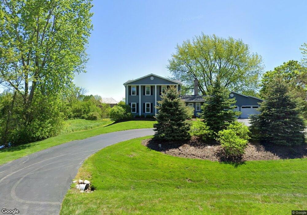
20855 N Pheasant Trail Barrington, IL 60010
Estimated Value: $589,164 - $775,000
--
Bed
3
Baths
2,022
Sq Ft
$333/Sq Ft
Est. Value
About This Home
This home is located at 20855 N Pheasant Trail, Barrington, IL 60010 and is currently estimated at $672,541, approximately $332 per square foot. 20855 N Pheasant Trail is a home located in Lake County with nearby schools including Arnett C. Lines Elementary School, Barrington Mdle School- Prairie Cmps, and Barrington High School.
Ownership History
Date
Name
Owned For
Owner Type
Purchase Details
Closed on
Feb 24, 1994
Sold by
Soeldner Rodger P
Bought by
Pokorny Michael T and Pokorny Malley B
Current Estimated Value
Home Financials for this Owner
Home Financials are based on the most recent Mortgage that was taken out on this home.
Original Mortgage
$274,500
Interest Rate
4.99%
Create a Home Valuation Report for This Property
The Home Valuation Report is an in-depth analysis detailing your home's value as well as a comparison with similar homes in the area
Home Values in the Area
Average Home Value in this Area
Purchase History
| Date | Buyer | Sale Price | Title Company |
|---|---|---|---|
| Pokorny Michael T | $203,333 | -- |
Source: Public Records
Mortgage History
| Date | Status | Borrower | Loan Amount |
|---|---|---|---|
| Closed | Pokorny Michael T | $274,500 |
Source: Public Records
Tax History Compared to Growth
Tax History
| Year | Tax Paid | Tax Assessment Tax Assessment Total Assessment is a certain percentage of the fair market value that is determined by local assessors to be the total taxable value of land and additions on the property. | Land | Improvement |
|---|---|---|---|---|
| 2024 | $9,667 | $167,663 | $47,445 | $120,218 |
| 2023 | $9,044 | $158,408 | $44,826 | $113,582 |
| 2022 | $9,044 | $144,765 | $43,960 | $100,805 |
| 2021 | $8,838 | $141,055 | $42,833 | $98,222 |
| 2020 | $8,962 | $141,055 | $42,833 | $98,222 |
| 2019 | $8,761 | $139,824 | $42,459 | $97,365 |
| 2018 | $8,727 | $142,531 | $45,675 | $96,856 |
| 2017 | $8,649 | $140,813 | $45,124 | $95,689 |
| 2016 | $8,645 | $136,354 | $43,695 | $92,659 |
| 2015 | $8,239 | $129,873 | $41,618 | $88,255 |
| 2014 | $8,780 | $131,076 | $47,760 | $83,316 |
| 2012 | $8,412 | $131,352 | $47,861 | $83,491 |
Source: Public Records
Map
Nearby Homes
- 20633 N Primrose Ct
- 23036 W Long Grove Rd
- 21355 N Bobwhite Ln
- 36 Ferndale Rd
- 44 Oak Ridge Ln
- 104 Lois Ln
- 1202 Tracie Dr
- 21 Ferndale Rd
- 1254 Tracie Dr
- 523 N Ela Rd
- 20358 N Wallingford Ln
- 555 Waterford Dr
- 21186 W Preserve Dr
- 21763 Deerpath Rd
- 20992 W Preserve Dr
- 822 Woodbine Cir
- 21326 N Elder Ct
- 1312 Lake Shore Dr N Unit 7
- 21742 N Ashley St
- 21725 N Ashley St
- 20815 N Pheasant Trail
- 20905 N Pheasant Trail
- 20877 N Wildrose Dr
- 20785 N Juniper Ln
- 23370 W Juniper Ln
- 20919 N Wildrose Dr
- 23385 W Cattail Ln
- 20925 N Pheasant Trail
- 20831 N Wildrose Dr
- 20795 N Wildrose Dr
- 20822 N Juniper Ln
- 20757 N Juniper Ln
- 20868 N Juniper Ln
- 23405 W Cattail Ln
- 20945 N Wildrose Dr
- 20770 N Juniper Ln
- 23266 W Fairview Dr
- 20975 N Pheasant Trail
- 20865 N Juniper Ln
- 20912 N Juniper Ln