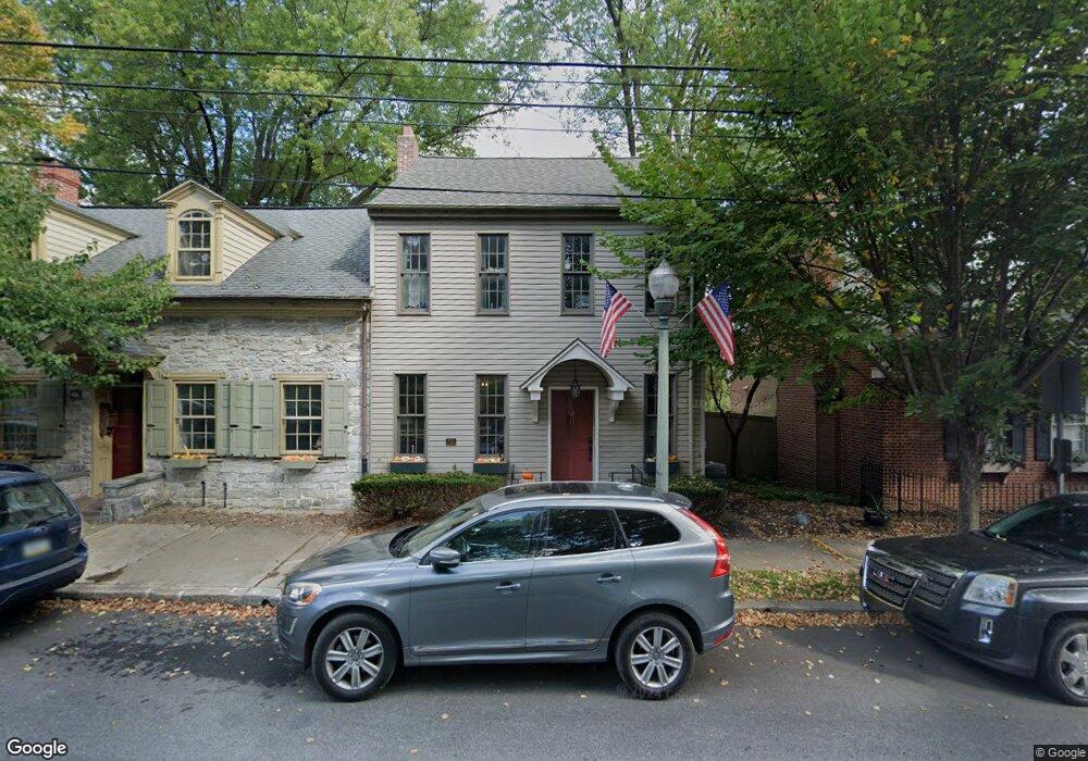
209 E Main St Lititz, PA 17543
Estimated Value: $287,809 - $342,000
3
Beds
1
Bath
1,344
Sq Ft
$237/Sq Ft
Est. Value
About This Home
This home is located at 209 E Main St, Lititz, PA 17543 and is currently estimated at $318,702, approximately $237 per square foot. 209 E Main St is a home located in Lancaster County with nearby schools including Warwick Senior High School, Lititz Christian School, and Linden Hall.
Ownership History
Date
Name
Owned For
Owner Type
Purchase Details
Closed on
Jun 27, 2012
Sold by
Concklin Bert M and Smedley Janet
Bought by
Concklin Bert M and Smedley Janet
Current Estimated Value
Purchase Details
Closed on
Jan 6, 2004
Sold by
Fuhrer Mark S and Fuhrer Cynthia K
Bought by
Concklin Bert M
Purchase Details
Closed on
Sep 29, 2000
Sold by
Tshudy Clyde R and Tshudy Barbara Ann
Bought by
Minnich Douglas L
Home Financials for this Owner
Home Financials are based on the most recent Mortgage that was taken out on this home.
Original Mortgage
$100,000
Interest Rate
7.96%
Create a Home Valuation Report for This Property
The Home Valuation Report is an in-depth analysis detailing your home's value as well as a comparison with similar homes in the area
Home Values in the Area
Average Home Value in this Area
Purchase History
| Date | Buyer | Sale Price | Title Company |
|---|---|---|---|
| Concklin Bert M | -- | None Available | |
| Concklin Bert M | $210,000 | -- | |
| Minnich Douglas L | $70,000 | -- |
Source: Public Records
Mortgage History
| Date | Status | Borrower | Loan Amount |
|---|---|---|---|
| Previous Owner | Minnich Douglas L | $100,000 |
Source: Public Records
Tax History
| Year | Tax Paid | Tax Assessment Tax Assessment Total Assessment is a certain percentage of the fair market value that is determined by local assessors to be the total taxable value of land and additions on the property. | Land | Improvement |
|---|---|---|---|---|
| 2025 | $3,414 | $150,900 | $47,000 | $103,900 |
| 2024 | $3,414 | $150,900 | $47,000 | $103,900 |
| 2023 | $3,400 | $150,900 | $47,000 | $103,900 |
| 2022 | $3,211 | $150,900 | $47,000 | $103,900 |
| 2021 | $3,211 | $150,900 | $47,000 | $103,900 |
| 2020 | $3,211 | $150,900 | $47,000 | $103,900 |
| 2019 | $3,211 | $150,900 | $47,000 | $103,900 |
| 2018 | $2,356 | $150,900 | $47,000 | $103,900 |
| 2017 | $3,919 | $144,700 | $31,500 | $113,200 |
| 2016 | $3,919 | $144,700 | $31,500 | $113,200 |
| 2015 | $917 | $144,700 | $31,500 | $113,200 |
| 2014 | $2,738 | $144,700 | $31,500 | $113,200 |
Source: Public Records
Map
Nearby Homes
- 24 E Orange St
- LOT 14 Thaton Rd
- LOT 12 Thaton Rd
- 48 N Broad St Unit 205
- 45 Plum St
- 601 E Main St
- 133 S Spruce St
- 211 Noble St
- 147 S Spruce St
- 50 E 2nd Ave
- 146 S Oak St
- 213 N Locust St
- 213 Skylark Rd
- 3 Amberly Way
- 321 Pin Oak Dr
- 1500 Furnace Hills Pike
- 325 Balmer Rd
- 339 Cardinal Rd
- 504 Hensley St
- 637 Lititz Reserve Ln
- 207 E Main St
- 215 E Main St
- 201 E Main St
- 227 E Main St
- 153 E Main St
- 231 E Main St Unit 231
- 149 E Main St
- 125F E Main St
- 125F E Main St Unit S3E
- 235 E Main St
- 237 E Main St
- 239 E Main St
- 241 E Main St
- 8 Church Square
- 245 E Main St
- 134 E Main St
- 133 E Main St
- 249 E Main St
- 131 E Main St
- 6 Church Square
Your Personal Tour Guide
Ask me questions while you tour the home.