Estimated Value: $291,000 - $321,000
3
Beds
2
Baths
1,381
Sq Ft
$219/Sq Ft
Est. Value
About This Home
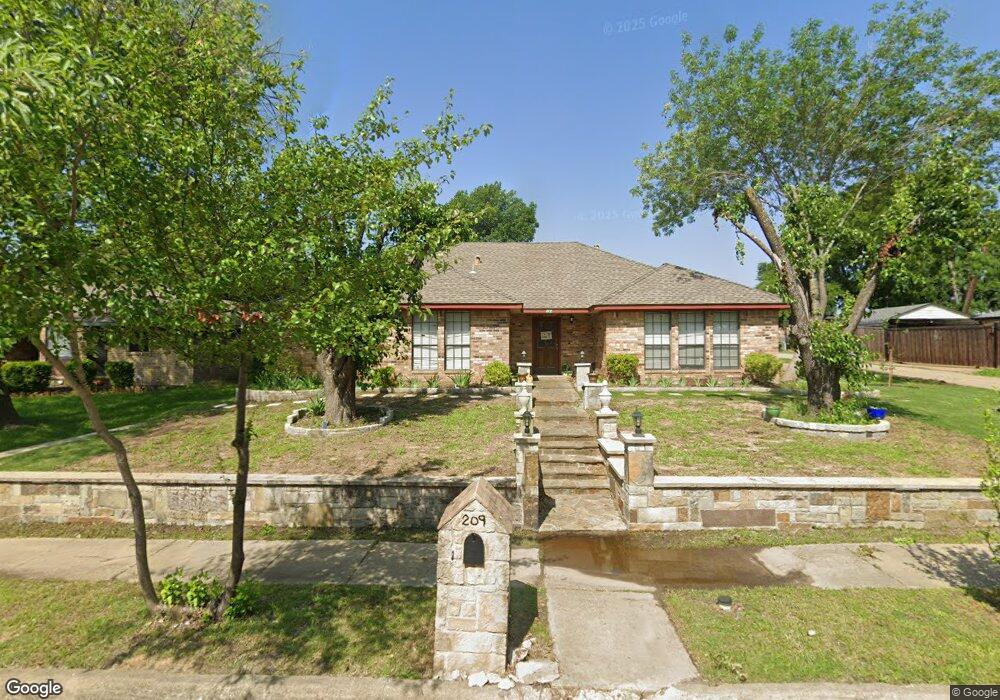
This home is located at 209 Liberty Dr, Wylie, TX 75098 and is currently estimated at $302,847, approximately $219 per square foot. 209 Liberty Dr is a home located in Collin County with nearby schools including P M Akin Elementary School, AB Harrison Intermediate School, and Grady Burnett J High School.
Ownership History
Date
Name
Owned For
Owner Type
Purchase Details
Closed on
Oct 14, 2005
Sold by
Federal National Mortgage Association
Bought by
Hernandez Fabian B
Current Estimated Value
Home Financials for this Owner
Home Financials are based on the most recent Mortgage that was taken out on this home.
Original Mortgage
$118,275
Outstanding Balance
$74,630
Interest Rate
8.75%
Mortgage Type
Fannie Mae Freddie Mac
Estimated Equity
$228,217
Purchase Details
Closed on
Jul 30, 1999
Sold by
Garwood Billy J and Garwood Lisa M
Bought by
Nettles Dennis and Nettles Donna
Home Financials for this Owner
Home Financials are based on the most recent Mortgage that was taken out on this home.
Original Mortgage
$89,200
Interest Rate
7.63%
Create a Home Valuation Report for This Property
The Home Valuation Report is an in-depth analysis detailing your home's value as well as a comparison with similar homes in the area
Home Values in the Area
Average Home Value in this Area
Purchase History
| Date | Buyer | Sale Price | Title Company |
|---|---|---|---|
| Hernandez Fabian B | -- | Stnt | |
| Nettles Dennis | -- | -- |
Source: Public Records
Mortgage History
| Date | Status | Borrower | Loan Amount |
|---|---|---|---|
| Open | Hernandez Fabian B | $118,275 | |
| Previous Owner | Nettles Dennis | $89,200 |
Source: Public Records
Tax History Compared to Growth
Tax History
| Year | Tax Paid | Tax Assessment Tax Assessment Total Assessment is a certain percentage of the fair market value that is determined by local assessors to be the total taxable value of land and additions on the property. | Land | Improvement |
|---|---|---|---|---|
| 2025 | $5,314 | $263,780 | $80,000 | $183,780 |
| 2024 | $5,314 | $269,037 | $80,000 | $189,037 |
| 2023 | $5,314 | $266,796 | $80,000 | $187,464 |
| 2022 | $5,321 | $242,542 | $65,000 | $195,984 |
| 2021 | $5,188 | $220,493 | $65,000 | $155,493 |
| 2020 | $4,985 | $200,749 | $50,000 | $150,749 |
| 2019 | $5,110 | $194,449 | $50,000 | $166,091 |
| 2018 | $4,761 | $176,772 | $50,000 | $159,077 |
| 2017 | $4,328 | $160,702 | $30,000 | $130,702 |
| 2016 | $4,088 | $150,845 | $30,000 | $120,845 |
| 2015 | $3,486 | $133,746 | $30,000 | $103,746 |
Source: Public Records
Map
Nearby Homes
- 207 Spence Dr
- 114 Liberty Dr
- 310 Hawthorn Dr
- 304 Hawthorn Dr
- 104 N 5th St
- 104 Rushcreek Dr
- 1022 Debby Ct
- 303 N 2nd St
- 216 Cedar Ridge St
- 409 Cedar Ridge Dr
- 300 Woodhollow Ct
- 306 Woodhollow Ct
- 825 Foxwood Ln
- 301 S 3rd St
- 820 Foxwood Ln
- 213 N West A Allen Blvd
- 811 Forest Edge Ln
- 825 Forest Edge Ln
- 1056 Fairview Dr
- 416 Dogwood Dr