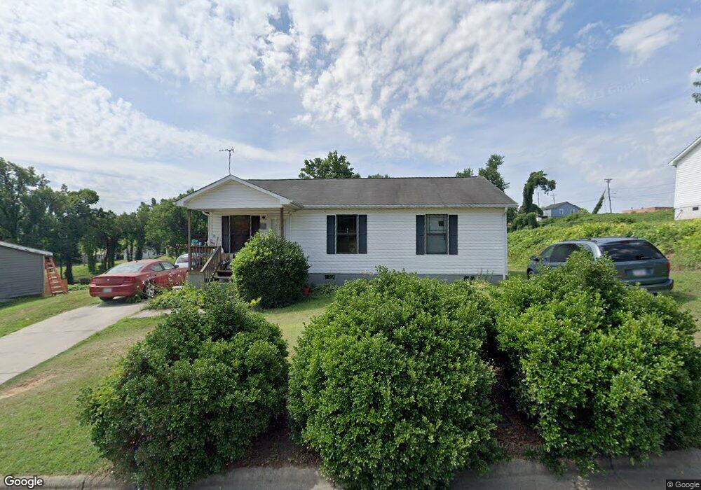
209 Lytle St Reidsville, NC 27320
Estimated Value: $141,000 - $190,000
3
Beds
2
Baths
1,120
Sq Ft
$140/Sq Ft
Est. Value
About This Home
This home is located at 209 Lytle St, Reidsville, NC 27320 and is currently estimated at $156,868, approximately $140 per square foot. 209 Lytle St is a home located in Rockingham County with nearby schools including Moss Street Elementary, Reidsville High School, and Reidsville Middle School.
Ownership History
Date
Name
Owned For
Owner Type
Purchase Details
Closed on
Jun 15, 2015
Sold by
Greater Reidsville Habitat For Humanity
Bought by
Hairston Henry Thomas and Hairston Katrina L
Current Estimated Value
Purchase Details
Closed on
Nov 18, 2014
Sold by
Pinkard Betsy G
Bought by
Greater Reidsville Habitat For Humanity
Purchase Details
Closed on
Mar 16, 2006
Sold by
Habitat Greater Reidsville
Bought by
Pinkard Betsy
Create a Home Valuation Report for This Property
The Home Valuation Report is an in-depth analysis detailing your home's value as well as a comparison with similar homes in the area
Home Values in the Area
Average Home Value in this Area
Purchase History
| Date | Buyer | Sale Price | Title Company |
|---|---|---|---|
| Hairston Henry Thomas | $22,000 | Attorney | |
| Greater Reidsville Habitat For Humanity | $36,000 | None Available | |
| Pinkard Betsy | $37,500 | None Available |
Source: Public Records
Tax History Compared to Growth
Tax History
| Year | Tax Paid | Tax Assessment Tax Assessment Total Assessment is a certain percentage of the fair market value that is determined by local assessors to be the total taxable value of land and additions on the property. | Land | Improvement |
|---|---|---|---|---|
| 2025 | $835 | $134,728 | $5,060 | $129,668 |
| 2024 | $435 | $134,728 | $5,060 | $129,668 |
| 2023 | $435 | $82,678 | $3,680 | $78,998 |
| 2022 | $593 | $82,678 | $3,680 | $78,998 |
| 2021 | $1,186 | $82,678 | $3,680 | $78,998 |
| 2020 | $593 | $82,678 | $3,680 | $78,998 |
| 2019 | $1,186 | $82,678 | $3,680 | $78,998 |
| 2018 | $1,221 | $85,042 | $6,640 | $78,402 |
| 2017 | $1,221 | $85,042 | $6,640 | $78,402 |
| 2015 | $673 | $85,042 | $6,640 | $78,402 |
| 2014 | $1,221 | $85,042 | $6,640 | $78,402 |
Source: Public Records
Map
Nearby Homes
- 115 N Harris St
- 00 E Morehead St
- 117 Ridge St
- 312 Church St
- 101 S Branch St
- 137 Ridge St
- 122 N Main St
- 403 Pennsylvania Ave
- 304 Roanoke St
- 106 Arlington St
- 335 S Branch St
- 309 Leary Cir Unit 311
- 217 Carter St Unit A & B
- 105 N Franklin St
- 308 S Main St
- 210 N Franklin St
- 00 Robinson Cir
- 112 Field St
- 319 Maple Ave
- 409 Lindsey St