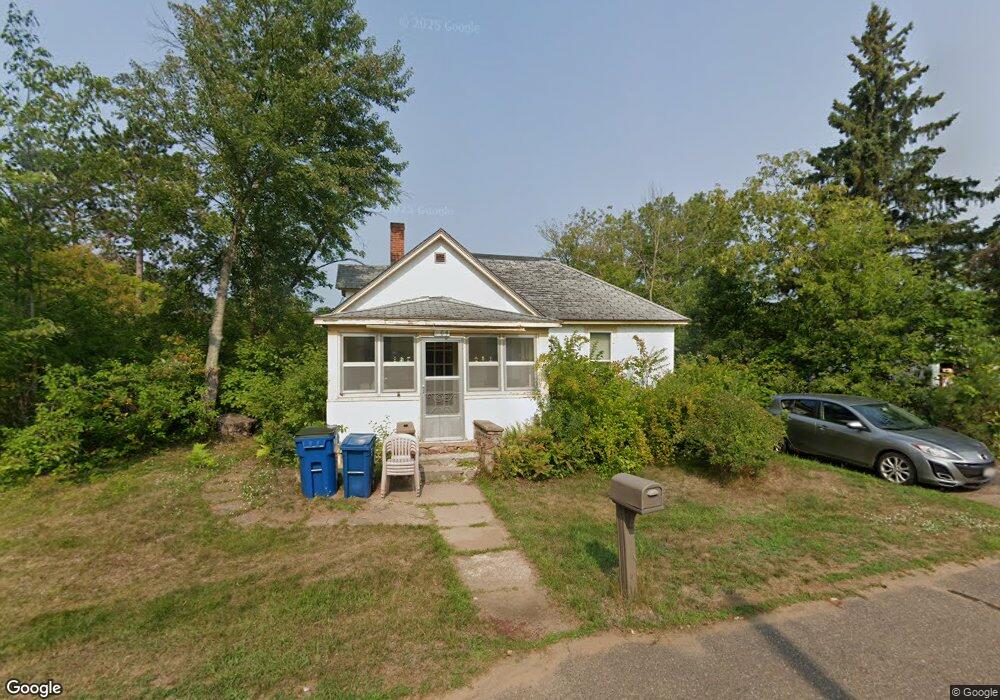
209 Mavis St Spooner, WI 54801
Estimated Value: $85,833 - $209,000
2
Beds
1
Bath
1,006
Sq Ft
$147/Sq Ft
Est. Value
About This Home
This home is located at 209 Mavis St, Spooner, WI 54801 and is currently estimated at $147,417, approximately $146 per square foot. 209 Mavis St is a home located in Washburn County with nearby schools including Spooner Elementary School, Spooner Middle School, and Spooner High School.
Ownership History
Date
Name
Owned For
Owner Type
Purchase Details
Closed on
Jan 19, 2009
Sold by
Dassow Crissie J
Bought by
Brobst Nina
Current Estimated Value
Purchase Details
Closed on
Apr 18, 2008
Sold by
Danklefsenraymond Sherie
Bought by
Dassow Crissie J
Create a Home Valuation Report for This Property
The Home Valuation Report is an in-depth analysis detailing your home's value as well as a comparison with similar homes in the area
Purchase History
| Date | Buyer | Sale Price | Title Company |
|---|---|---|---|
| Brobst Nina | $40,000 | -- | |
| Dassow Crissie J | $52,000 | -- | |
| Danklefsen Raymond Sherie | $52,000 | -- |
Source: Public Records
Mortgage History
| Date | Status | Borrower | Loan Amount |
|---|---|---|---|
| Closed | Danklefsen Raymond Sherie | $0 |
Source: Public Records
Tax History
| Year | Tax Paid | Tax Assessment Tax Assessment Total Assessment is a certain percentage of the fair market value that is determined by local assessors to be the total taxable value of land and additions on the property. | Land | Improvement |
|---|---|---|---|---|
| 2025 | $1,277 | $92,000 | $26,000 | $66,000 |
| 2023 | $1,173 | $46,400 | $19,000 | $27,400 |
| 2022 | $1,058 | $46,400 | $19,000 | $27,400 |
| 2021 | $1,055 | $46,400 | $19,000 | $27,400 |
| 2020 | $1,057 | $46,400 | $19,000 | $27,400 |
| 2019 | $1,017 | $46,400 | $19,000 | $27,400 |
| 2018 | $988 | $46,400 | $19,000 | $27,400 |
| 2017 | $974 | $46,400 | $19,000 | $27,400 |
| 2016 | $969 | $46,400 | $19,000 | $27,400 |
| 2015 | $927 | $46,400 | $19,000 | $27,400 |
| 2014 | $907 | $46,400 | $19,000 | $27,400 |
| 2012 | -- | $46,400 | $19,000 | $27,400 |
Source: Public Records
Map
Nearby Homes
- XXX Dur A Bilt Rd
- XXX Pine Dr
- 607 College St
- 0 Hwy 70 Unit 1594695
- 1102 Whitetail St
- 1540 Woodland St
- 1120 Northland Dr
- 924 Superior St
- 1114 Michigan St
- xxx Trails End
- Lot 5 Spooner Outlet Dr
- Lot 4 Spooner Outlet Dr
- Lot 3 Spooner Outlet Dr
- Lot 6 Spooner Outlet Dr
- Lot 8 Spooner Outlet Dr
- Lot 7 Spooner Outlet Dr
- Lot 9 Spooner Outlet Dr
- W7234 Wilbur Dr
- 0 U S 53
- 7395 Miller Rd
- 201 Mavis St
- 116 Mcleod Ave
- 209 Oseewee Plaisance
- 115 Mavis St
- 430 Oseewee Plaisance
- 422 Oseewee Plaisance
- 208 Mcleod Ave
- 314 Oseewee Plaisance
- 306 Oseewee Plaisance
- 298 Oseewee Plaisance
- 212 Mavis St
- 206 Mavis St
- 105 Oseewee Plaisance
- 206 Mcleod Ave
- 110 Mavis St
- 126 Mcleod Ave
- 123 Mcleod Ave
- 110 Mcleod Ave
- 313 E Maple St Unit 1-2
- 326 Miller Ave
Your Personal Tour Guide
Ask me questions while you tour the home.