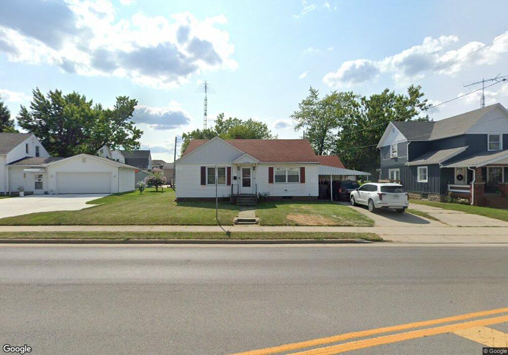
209 N Shoop Ave Wauseon, OH 43567
Estimated Value: $116,000 - $151,000
2
Beds
1
Bath
1,016
Sq Ft
$126/Sq Ft
Est. Value
About This Home
This home is located at 209 N Shoop Ave, Wauseon, OH 43567 and is currently estimated at $128,077, approximately $126 per square foot. 209 N Shoop Ave is a home located in Fulton County with nearby schools including Wauseon Primary School, Wauseon Elementary School, and Wauseon Middle School.
Ownership History
Date
Name
Owned For
Owner Type
Purchase Details
Closed on
May 13, 2014
Sold by
Haver James R and Haver Joanne L
Bought by
Haver James R
Current Estimated Value
Purchase Details
Closed on
Jun 3, 2009
Sold by
Borton Gay and Estate Of Tina M Mattin
Bought by
Haver James R
Purchase Details
Closed on
Aug 11, 2000
Sold by
Flory Carol E
Bought by
Mattin Tina M
Home Financials for this Owner
Home Financials are based on the most recent Mortgage that was taken out on this home.
Original Mortgage
$15,675
Interest Rate
8.24%
Mortgage Type
New Conventional
Purchase Details
Closed on
Jan 9, 1995
Sold by
Lucille Wood
Bought by
Carol E Flory
Purchase Details
Closed on
Jan 1, 1990
Bought by
Flory Carol E
Create a Home Valuation Report for This Property
The Home Valuation Report is an in-depth analysis detailing your home's value as well as a comparison with similar homes in the area
Home Values in the Area
Average Home Value in this Area
Purchase History
| Date | Buyer | Sale Price | Title Company |
|---|---|---|---|
| Haver James R | -- | Attorney | |
| Haver James R | $36,666 | Attorney | |
| Mattin Tina M | $77,500 | -- | |
| Carol E Flory | $65,000 | -- | |
| Flory Carol E | -- | -- |
Source: Public Records
Mortgage History
| Date | Status | Borrower | Loan Amount |
|---|---|---|---|
| Previous Owner | Mattin Tina M | $15,675 |
Source: Public Records
Tax History Compared to Growth
Tax History
| Year | Tax Paid | Tax Assessment Tax Assessment Total Assessment is a certain percentage of the fair market value that is determined by local assessors to be the total taxable value of land and additions on the property. | Land | Improvement |
|---|---|---|---|---|
| 2024 | $1,540 | $30,310 | $5,110 | $25,200 |
| 2023 | $1,540 | $30,310 | $5,110 | $25,200 |
| 2022 | $1,371 | $22,930 | $4,270 | $18,660 |
| 2021 | $1,465 | $22,930 | $4,270 | $18,660 |
| 2020 | $1,349 | $22,930 | $4,270 | $18,660 |
| 2019 | $1,336 | $22,370 | $4,060 | $18,310 |
| 2018 | $1,173 | $22,370 | $4,060 | $18,310 |
| 2017 | $1,159 | $22,370 | $4,060 | $18,310 |
| 2016 | $1,124 | $19,360 | $4,060 | $15,300 |
| 2015 | $1,054 | $19,360 | $4,060 | $15,300 |
| 2014 | $1,005 | $19,360 | $4,060 | $15,300 |
| 2013 | $1,362 | $24,300 | $3,680 | $20,620 |
Source: Public Records
Map
Nearby Homes
- 527 E Elm St
- 524 E Elm St
- 217 Marshall St
- 139 Marshall St
- 351 E Walnut St
- 00 Glenwood
- 0 Glenwood Unit 6124946
- 303 Eastwood St
- 125 Cherry St
- 234 W Chestnut St
- 227 Wabash St
- 252 W Chestnut St
- 840 Pine St
- 824 N Ottokee St
- 622 Vine St
- 420 Clover Ln
- 1066 Seneca Dr
- 1062 Seneca Dr
- 1090 Seneca Dr
- Integrity 1830 Plan at Arrowhead Trails