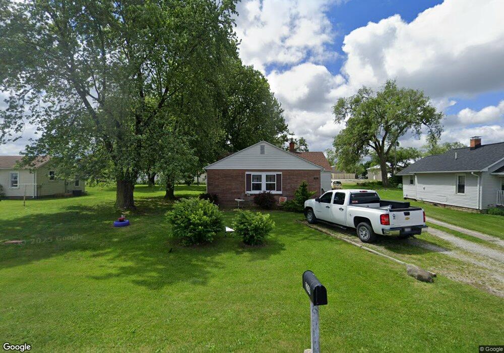
209 Piatt Ave Mattoon, IL 61938
Estimated Value: $69,671 - $112,000
3
Beds
1
Bath
1,277
Sq Ft
$72/Sq Ft
Est. Value
About This Home
This home is located at 209 Piatt Ave, Mattoon, IL 61938 and is currently estimated at $92,418, approximately $72 per square foot. 209 Piatt Ave is a home located in Coles County with nearby schools including Mattoon High School, St. John's Lutheran School, and St Mary School.
Ownership History
Date
Name
Owned For
Owner Type
Purchase Details
Closed on
Jul 20, 2011
Sold by
Kuhn Theron and Tucker Valerie B
Bought by
Lee Charles and Le Alice
Current Estimated Value
Home Financials for this Owner
Home Financials are based on the most recent Mortgage that was taken out on this home.
Original Mortgage
$61,450
Outstanding Balance
$42,296
Interest Rate
4.52%
Mortgage Type
New Conventional
Estimated Equity
$50,122
Purchase Details
Closed on
Feb 10, 2006
Sold by
Lee David H and Lee Karen A
Bought by
Tucker Valerie B and Kuhn Theron
Home Financials for this Owner
Home Financials are based on the most recent Mortgage that was taken out on this home.
Original Mortgage
$56,990
Interest Rate
6.34%
Mortgage Type
FHA
Create a Home Valuation Report for This Property
The Home Valuation Report is an in-depth analysis detailing your home's value as well as a comparison with similar homes in the area
Home Values in the Area
Average Home Value in this Area
Purchase History
| Date | Buyer | Sale Price | Title Company |
|---|---|---|---|
| Lee Charles | $57,500 | None Available | |
| Tucker Valerie B | $67,500 | None Available |
Source: Public Records
Mortgage History
| Date | Status | Borrower | Loan Amount |
|---|---|---|---|
| Open | Lee Charles | $61,450 | |
| Previous Owner | Tucker Valerie B | $56,990 |
Source: Public Records
Tax History
| Year | Tax Paid | Tax Assessment Tax Assessment Total Assessment is a certain percentage of the fair market value that is determined by local assessors to be the total taxable value of land and additions on the property. | Land | Improvement |
|---|---|---|---|---|
| 2024 | $707 | $19,044 | $1,789 | $17,255 |
| 2023 | $524 | $17,157 | $1,612 | $15,545 |
| 2022 | $524 | $16,873 | $1,585 | $15,288 |
| 2021 | $457 | $15,201 | $1,428 | $13,773 |
| 2020 | $411 | $15,750 | $4,647 | $11,103 |
| 2019 | $399 | $15,201 | $4,485 | $10,716 |
| 2018 | $392 | $15,201 | $4,485 | $10,716 |
| 2017 | $391 | $15,201 | $4,485 | $10,716 |
| 2016 | $401 | $15,676 | $4,485 | $11,191 |
| 2015 | $840 | $15,369 | $4,397 | $10,972 |
| 2014 | $840 | $15,369 | $4,397 | $10,972 |
| 2013 | $840 | $15,369 | $4,397 | $10,972 |
Source: Public Records
Map
Nearby Homes
- 304 Dewitt Ave
- 421 Dewitt Ave
- 812 N 8th St Unit 64
- 812 N 8th St Unit 36
- 916 Piatt Ave
- 1401 N 10th St
- 1 Brown Ct
- 1412 Champaign Ave
- 420 Crestview Dr
- 1101 Wabash Ave
- 22 Elm Ridge
- 1612 Richmond Ave
- 1301 Lafayette Ave
- 1800 Piatt Ave
- 1312 Edgar Ave
- 1905 Dewitt Ave
- 1509 Lafayette Ave
- 1012 S 6th St
- 521 S 17th St
- 309 Essex Ave
Your Personal Tour Guide
Ask me questions while you tour the home.