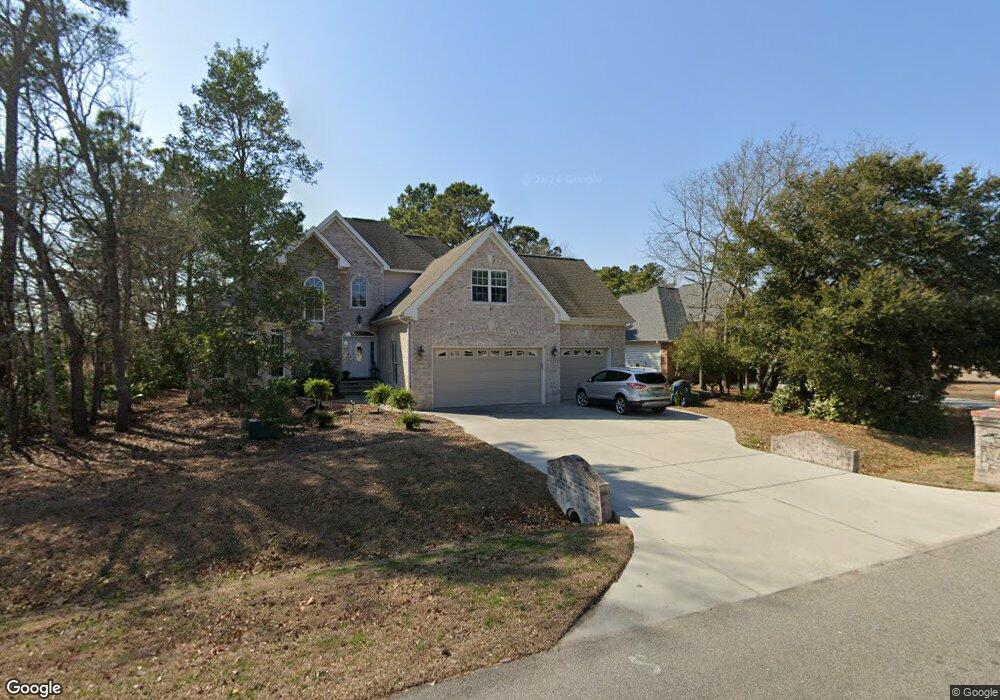
209 Port Side Dr Sneads Ferry, NC 28460
Estimated Value: $517,467 - $556,000
4
Beds
3
Baths
2,694
Sq Ft
$198/Sq Ft
Est. Value
About This Home
This home is located at 209 Port Side Dr, Sneads Ferry, NC 28460 and is currently estimated at $534,367, approximately $198 per square foot. 209 Port Side Dr is a home located in Onslow County with nearby schools including Dixon Elementary School, Coastal Elementary, and Dixon High School.
Ownership History
Date
Name
Owned For
Owner Type
Purchase Details
Closed on
Sep 18, 2021
Sold by
Peer Brittany and Peer Matthew
Bought by
Baker Eric H
Current Estimated Value
Purchase Details
Closed on
Aug 4, 2009
Sold by
The Chad L Fogle & Janet R Fogle Revocab
Bought by
Fogle Chad L and Fogle Janet R
Purchase Details
Closed on
Feb 25, 2005
Sold by
Fogle Janet R
Bought by
Fogle Chad L and Janet R Fogle Revocable L
Create a Home Valuation Report for This Property
The Home Valuation Report is an in-depth analysis detailing your home's value as well as a comparison with similar homes in the area
Home Values in the Area
Average Home Value in this Area
Purchase History
| Date | Buyer | Sale Price | Title Company |
|---|---|---|---|
| Baker Eric H | -- | None Available | |
| Fogle Chad L | -- | None Available | |
| Fogle Chad L | -- | None Available |
Source: Public Records
Tax History Compared to Growth
Tax History
| Year | Tax Paid | Tax Assessment Tax Assessment Total Assessment is a certain percentage of the fair market value that is determined by local assessors to be the total taxable value of land and additions on the property. | Land | Improvement |
|---|---|---|---|---|
| 2025 | $2,739 | $418,166 | $42,500 | $375,666 |
| 2024 | $2,739 | $418,166 | $42,500 | $375,666 |
| 2023 | $2,739 | $418,166 | $42,500 | $375,666 |
| 2022 | $2,739 | $418,166 | $42,500 | $375,666 |
| 2021 | $2,037 | $288,890 | $38,000 | $250,890 |
| 2020 | $2,037 | $288,890 | $38,000 | $250,890 |
| 2019 | $2,037 | $288,890 | $38,000 | $250,890 |
| 2018 | $2,037 | $288,890 | $38,000 | $250,890 |
| 2017 | $1,990 | $294,830 | $55,000 | $239,830 |
| 2016 | $1,990 | $294,830 | $0 | $0 |
| 2015 | $1,990 | $294,830 | $0 | $0 |
| 2014 | $1,990 | $294,830 | $0 | $0 |
Source: Public Records
Map
Nearby Homes
- 107 Sea Turtle Cove
- L6 N Carolina 210
- Pt L6 N Carolina 210
- 1008 Mill Run Rd
- L7 State Highway 210
- 104 Rollingwood Cir
- 108 Rollingwood Cir
- 113 Windy Point
- 102 Pirates Cove
- 315 Seascape Dr
- 300 Sea Urchin Cove
- 281 Mimosa Dr
- 161 Marina Wynd Way
- 262 Cuddy Ct
- 110 Sea Level Ln
- 186 Snow Goose Ln
- 917 Old Folkstone Rd
- 402 Canvasback Ln
- 408 Canvasback Ln
- 311 Royal Eagle Ct
- 209 Portside Dr
- 211 Port Side Dr
- 207 Port Side Dr
- 213 Port Side Dr
- 205 Port Side Dr
- 206 Port Side Dr
- 208 Port Side Dr
- 204 Port Side Dr
- 210 Port Side Dr
- 215 Port Side Dr
- 203 Port Side Dr
- 212 Port Side Dr
- 505 N Shore
- 503 N Shore Dr
- 201 Port Side Dr
- 201 N Shore Dr
- 501 N Shore Dr
- 200 Port Side Dr
- 214 Port Side Dr Unit Drive
- 214 Port Side Dr