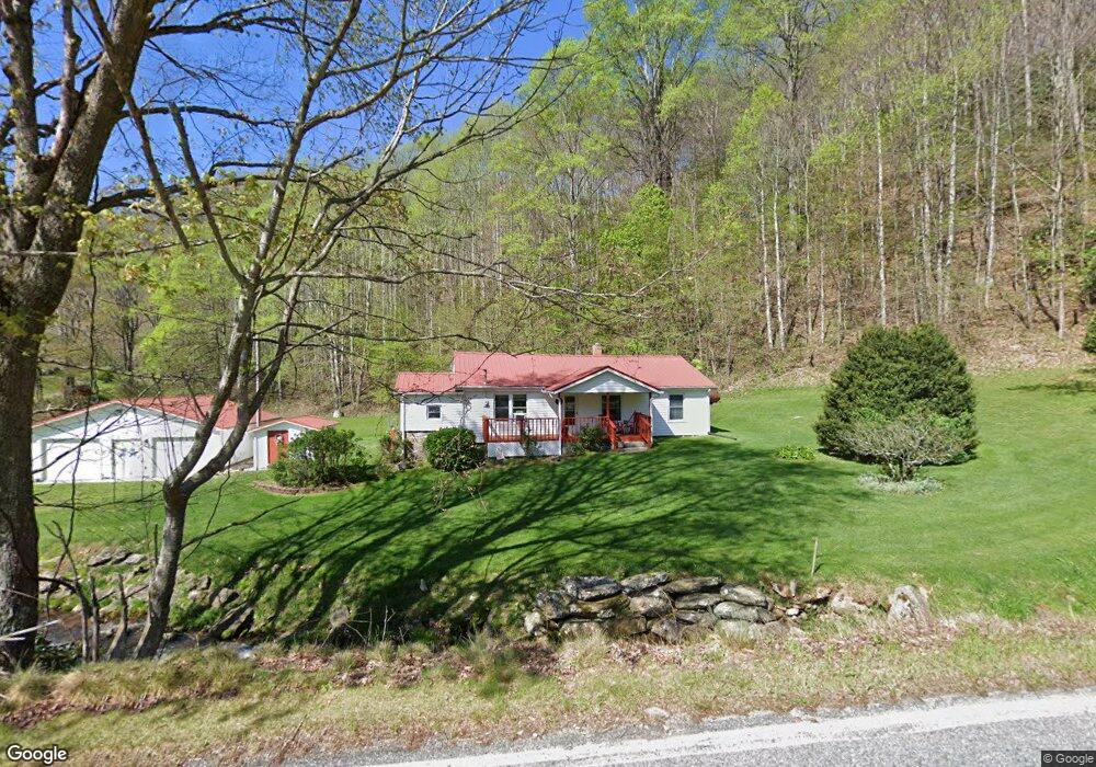
209 Roaring Fork Rd Burnsville, NC 28714
Estimated Value: $275,038 - $384,000
3
Beds
1
Bath
1,266
Sq Ft
$253/Sq Ft
Est. Value
About This Home
This home is located at 209 Roaring Fork Rd, Burnsville, NC 28714 and is currently estimated at $319,760, approximately $252 per square foot. 209 Roaring Fork Rd is a home with nearby schools including Mountain Heritage High School.
Ownership History
Date
Name
Owned For
Owner Type
Purchase Details
Closed on
Dec 18, 2015
Sold by
Watson Linda E and Watson Oswald
Bought by
Watson Oswald and Watson Linda E
Current Estimated Value
Purchase Details
Closed on
Jun 2, 2015
Sold by
Watson Elaine and Watson Oswald
Bought by
Watson Elaine and Watson Oswald
Purchase Details
Closed on
May 5, 2003
Bought by
Watson Elaine
Create a Home Valuation Report for This Property
The Home Valuation Report is an in-depth analysis detailing your home's value as well as a comparison with similar homes in the area
Home Values in the Area
Average Home Value in this Area
Purchase History
| Date | Buyer | Sale Price | Title Company |
|---|---|---|---|
| Watson Oswald | -- | None Available | |
| Watson Elaine | -- | None Available | |
| Watson Elaine | $18,000 | -- |
Source: Public Records
Tax History Compared to Growth
Tax History
| Year | Tax Paid | Tax Assessment Tax Assessment Total Assessment is a certain percentage of the fair market value that is determined by local assessors to be the total taxable value of land and additions on the property. | Land | Improvement |
|---|---|---|---|---|
| 2025 | $1,471 | $258,100 | $149,900 | $108,200 |
| 2024 | $1,471 | $258,100 | $149,900 | $108,200 |
| 2023 | $806 | $123,930 | $67,600 | $56,330 |
| 2022 | $789 | $123,930 | $67,600 | $56,330 |
| 2021 | $806 | $123,930 | $67,600 | $56,330 |
| 2020 | $806 | $123,930 | $67,600 | $56,330 |
| 2019 | $806 | $123,930 | $67,600 | $56,330 |
| 2018 | $806 | $123,930 | $67,600 | $56,330 |
| 2017 | $806 | $123,930 | $67,600 | $56,330 |
| 2016 | $806 | $123,930 | $67,600 | $56,330 |
| 2015 | $758 | $137,830 | $75,100 | $62,730 |
| 2014 | $758 | $137,830 | $75,100 | $62,730 |
Source: Public Records
Map
Nearby Homes
- 15 +/- Acres Riddle Branch Rd
- 141 Locust Ramp Dr
- 2812 Bald Mountain Rd
- 1099 Silas Branch Rd
- #1 TBD Lotties Creek Rd Unit Lot 8, 39, 40, 41, 4
- #3 TBD Lotties Creek Rd Unit Lots 37, 42
- #2 TBD Lotties Creek Rd Unit Lots 19, 20, 23,25,2
- TBD Little Creek Rd
- 1393 Bald Mountain Rd
- 469 Hensley Branch Rd
- 128 Hadleigh Way
- 000 Pearl Way Unit 12
- Lot 11 Settlement Way
- Lot 8 Settlement Way
- Lot 6 Settlement Way
- 0000 Bee Log Rd
- 79 & 111 Hensley Branch Roads
- 79 & 111 Hensley Branch Rd
- 79 Hensley Branch Rd
- 337 Hamlin Ln Unit 96
- 141 Roaring Fork Rd
- 81 Old House Rock Ln
- 166 Roaring Fork Rd
- 4030 Bald Mountain Rd
- 3976 Bald Mountain Rd
- 3976 Bald Mountain Rd
- 4066 Bald Mountain Rd
- 86 Roaring Fork Rd
- 0 Roaring Fork Rd Unit NCM460172
- 0 Roaring Fork Rd Unit NCM460157
- 0 Roaring Fork Rd Unit NCM460174
- 0 Roaring Fork Rd Unit NCM460163
- 0 Roaring Fork Rd Unit NCM477667
- 0 Roaring Fork Rd Unit NCM477695
- 0 Roaring Fork Rd Unit NCM483199
- 0 Roaring Fork Rd Unit 6 NCM490741
- 0 Roaring Fork Rd Unit 33476
- 0 Roaring Fork Rd Unit NCM579079
- 000 Scronce Rd
- 4085 Bald Mountain Rd