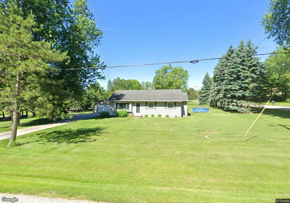
209 S Lapham Peak Rd Delafield, WI 53018
Estimated Value: $353,485 - $795,000
3
Beds
1
Bath
--
Sq Ft
0.76
Acres
About This Home
This home is located at 209 S Lapham Peak Rd, Delafield, WI 53018 and is currently estimated at $485,371. 209 S Lapham Peak Rd is a home located in Waukesha County with nearby schools including Cushing Elementary School, Kettle Moraine Middle School, and Kettle Moraine High School.
Ownership History
Date
Name
Owned For
Owner Type
Purchase Details
Closed on
Jul 14, 2004
Sold by
Nicholson Carol A and Harroun Carol A
Bought by
Nicholson Carol A
Current Estimated Value
Home Financials for this Owner
Home Financials are based on the most recent Mortgage that was taken out on this home.
Original Mortgage
$120,000
Interest Rate
6.4%
Mortgage Type
Stand Alone Refi Refinance Of Original Loan
Purchase Details
Closed on
Nov 23, 1998
Sold by
Harroun William F
Bought by
Nicholson Carol A and Harroun Carol A
Purchase Details
Closed on
Sep 15, 1998
Sold by
Harroun William F and Harroun Carol A
Bought by
Harroun William F and Harroun Carol A
Create a Home Valuation Report for This Property
The Home Valuation Report is an in-depth analysis detailing your home's value as well as a comparison with similar homes in the area
Home Values in the Area
Average Home Value in this Area
Purchase History
| Date | Buyer | Sale Price | Title Company |
|---|---|---|---|
| Nicholson Carol A | -- | -- | |
| Nicholson Carol A | -- | -- | |
| Harroun William F | -- | -- |
Source: Public Records
Mortgage History
| Date | Status | Borrower | Loan Amount |
|---|---|---|---|
| Closed | Nicholson Carol A | $120,000 |
Source: Public Records
Tax History
| Year | Tax Paid | Tax Assessment Tax Assessment Total Assessment is a certain percentage of the fair market value that is determined by local assessors to be the total taxable value of land and additions on the property. | Land | Improvement |
|---|---|---|---|---|
| 2024 | $3,162 | $224,000 | $103,700 | $120,300 |
| 2023 | $3,047 | $224,000 | $103,700 | $120,300 |
| 2022 | $2,588 | $224,000 | $103,700 | $120,300 |
| 2021 | $2,626 | $177,900 | $86,700 | $91,200 |
| 2020 | $2,700 | $177,900 | $86,700 | $91,200 |
| 2019 | $2,551 | $177,900 | $86,700 | $91,200 |
| 2018 | $2,499 | $177,900 | $86,700 | $91,200 |
| 2017 | $2,513 | $177,900 | $86,700 | $91,200 |
| 2016 | $2,549 | $177,900 | $86,700 | $91,200 |
| 2015 | $2,658 | $177,900 | $86,700 | $91,200 |
| 2014 | $2,803 | $177,900 | $86,700 | $91,200 |
| 2013 | $2,803 | $180,000 | $87,700 | $92,300 |
Source: Public Records
Map
Nearby Homes
- 311 S Lapham Peak Rd Unit 13
- 1001 Park Way
- 1026 Park Way
- 351 Stocks Dr
- 711 Division St
- 805 Wells St Unit 4
- 805 Wells St Unit 2
- 805 Wells St Unit 3
- 805 Wells St Unit 1
- 637 1st St
- W318N1045 Huckleberry Way N
- 716 Saint Johns Dr Unit 718
- 545 Wisconsin Ave
- 323 Riverview Dr
- 2135 W Shore Dr
- W339S271 Foxtail Ct
- 2736 Nagawicka Ave
- 762 N Forest Ridge Ct
- W331N3460 Maplewood Rd
- W304N2426 Maple Ave
- 1109 Bahr Rd
- Lot 1 Bahr Rd
- 1106 Bahr Rd
- 221 S Lapham Peak Rd
- Lt1 Bahr Rd
- 264 S Lapham Peak Rd
- 1021 Bahr Rd
- 210 S Lapham Peak Rd Unit 212
- 946 Bahr Rd
- 935 Bahr Rd
- 300 S Lapham Peak Rd
- 1204 Indian Spring Dr
- 231 S Lapham Peak Rd
- 936 Bahr Rd
- 940 Indian Spring Dr Unit 1050
- 426 S Lapham Peak Rd
- 929 Bahr Rd
- 1344 Indian Spring Dr
- 926 Bahr Rd
- 1322 Indian Spring Dr