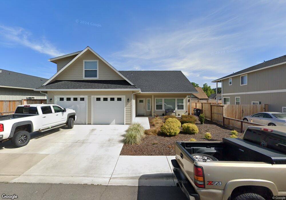
209 Samuel Lane Loop Rd Phoenix, OR 97535
Estimated Value: $504,000 - $583,000
2
Beds
1
Bath
875
Sq Ft
$624/Sq Ft
Est. Value
About This Home
This home is located at 209 Samuel Lane Loop Rd, Phoenix, OR 97535 and is currently estimated at $545,849, approximately $623 per square foot. 209 Samuel Lane Loop Rd is a home located in Jackson County with nearby schools including Phoenix Elementary School, Talent Middle School, and Phoenix High School.
Ownership History
Date
Name
Owned For
Owner Type
Purchase Details
Closed on
Jan 11, 2007
Sold by
Gritsch John M and Gritsch Helen E
Bought by
Gritsch Samuel Llc
Current Estimated Value
Purchase Details
Closed on
Sep 29, 2003
Sold by
Gritsch John M and Gritsch Helen E
Bought by
Gritsch Samuel Llc
Create a Home Valuation Report for This Property
The Home Valuation Report is an in-depth analysis detailing your home's value as well as a comparison with similar homes in the area
Home Values in the Area
Average Home Value in this Area
Purchase History
| Date | Buyer | Sale Price | Title Company |
|---|---|---|---|
| Gritsch Samuel Llc | -- | None Available | |
| Gritsch John M | -- | None Available | |
| Gritsch Samuel Llc | -- | -- |
Source: Public Records
Tax History
| Year | Tax Paid | Tax Assessment Tax Assessment Total Assessment is a certain percentage of the fair market value that is determined by local assessors to be the total taxable value of land and additions on the property. | Land | Improvement |
|---|---|---|---|---|
| 2026 | $5,585 | $309,090 | $121,000 | $188,090 |
| 2025 | $5,453 | $340,030 | $85,890 | $254,140 |
| 2024 | $5,453 | $330,130 | $83,390 | $246,740 |
| 2023 | $5,282 | $360,140 | $80,960 | $279,180 |
| 2022 | $4,159 | $259,280 | $80,960 | $178,320 |
| 2021 | $1,268 | $78,600 | $78,600 | $0 |
| 2020 | $3,433 | $213,400 | $70,050 | $143,350 |
| 2019 | $3,342 | $201,160 | $66,040 | $135,120 |
| 2018 | $3,244 | $195,310 | $64,110 | $131,200 |
| 2017 | $3,065 | $195,310 | $64,110 | $131,200 |
| 2016 | $2,982 | $184,110 | $60,440 | $123,670 |
| 2015 | $2,866 | $184,110 | $60,440 | $123,670 |
| 2014 | $2,758 | $173,550 | $56,970 | $116,580 |
Source: Public Records
Map
Nearby Homes
- 0 Colver Rd
- 817 Amerman Dr
- 401 Elm St
- 4624 S Pacific Hwy Unit 61
- 4624 S Pacific Hwy Unit 40
- 3712 Colver Rd
- 201 S Rose St
- 130 Sharon Dr
- 105 W 1st St
- 4601 S Pacific Hwy Unit 8
- 4729 S Pacific Hwy Unit 4
- 4729 S Pacific Hwy Unit 16
- 4729 S Pacific Hwy Unit 24
- 3459 S Pacific Hwy
- 111 E 1st St
- 316 W 3rd St
- 301 N Church St
- 300 Luman Rd Unit 200
- 510 N Main St
- 600 N Main St
- 213 Samuel Lane Loop Rd
- 205 Samuel Lane Loop Rd
- 262 Samuel Lane Loop Rd
- 266 Samuel Rd
- 201 Samuel Rd
- 201 Samuel Lane Loop Rd
- 258 Samuel Rd
- 258 Samuel Lane Loop Rd
- 266 Samuel Lane Loop Rd
- 217 Samuel Rd
- 217 Samuel Lane Loop Rd
- 241 Samuel Rd
- 270 Samuel Rd
- 241 Samuel Lane Loop Rd
- 270 Samuel Lane Loop Rd
- 221 Samuel Rd
- 221 Samuel Lane Loop Rd
- 124 Samuel Ln
- 255 Samuel Rd
- 259 Samuel Lane Loop Rd
Your Personal Tour Guide
Ask me questions while you tour the home.