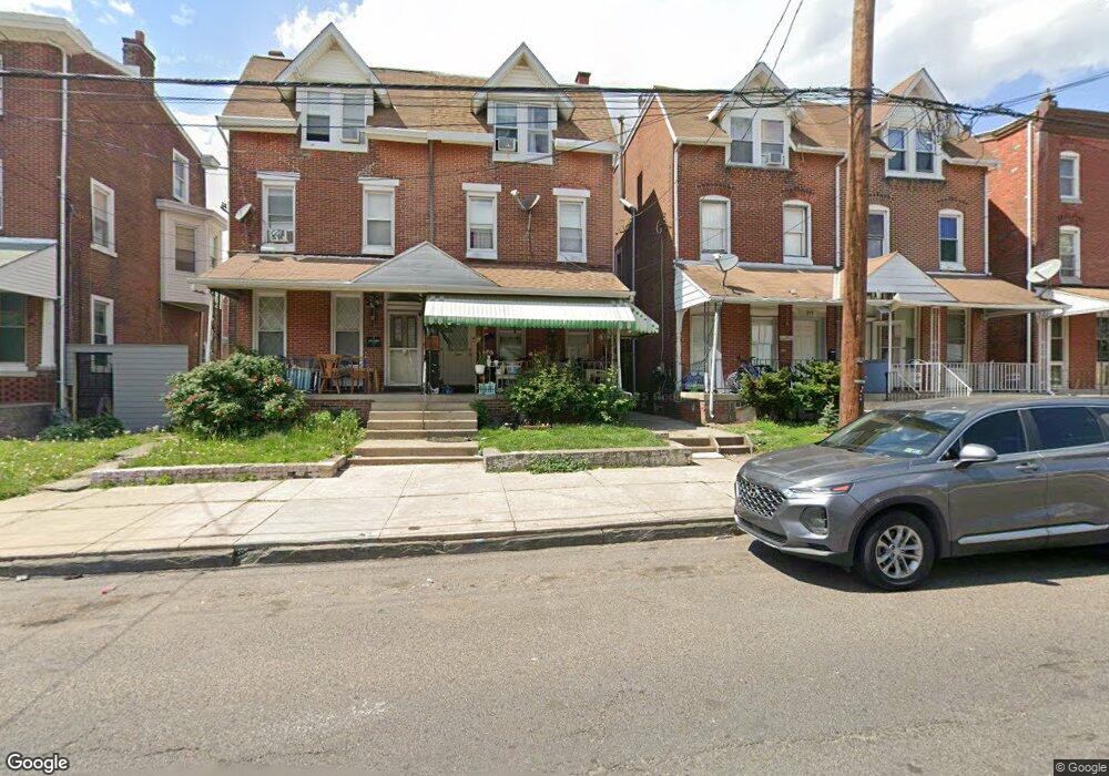
209 Stanbridge St Norristown, PA 19401
Estimated Value: $203,000 - $255,876
5
Beds
2
Baths
2,299
Sq Ft
$103/Sq Ft
Est. Value
About This Home
This home is located at 209 Stanbridge St, Norristown, PA 19401 and is currently estimated at $237,719, approximately $103 per square foot. 209 Stanbridge St is a home located in Montgomery County with nearby schools including Charles Blockson Middle School, Whitehall Elementary School, and East Norriton Middle School.
Ownership History
Date
Name
Owned For
Owner Type
Purchase Details
Closed on
Nov 2, 2009
Sold by
Hammond Ona and Hammond Gloria J
Bought by
Mejia Epitacio and Mejia Juan
Current Estimated Value
Purchase Details
Closed on
Dec 7, 2006
Sold by
Hammond Gloria J
Bought by
Hammonnd Ona and Hammond Gloria J
Home Financials for this Owner
Home Financials are based on the most recent Mortgage that was taken out on this home.
Original Mortgage
$32,400
Interest Rate
6.35%
Create a Home Valuation Report for This Property
The Home Valuation Report is an in-depth analysis detailing your home's value as well as a comparison with similar homes in the area
Home Values in the Area
Average Home Value in this Area
Purchase History
| Date | Buyer | Sale Price | Title Company |
|---|---|---|---|
| Mejia Epitacio | $49,000 | None Available | |
| Hammonnd Ona | -- | None Available |
Source: Public Records
Mortgage History
| Date | Status | Borrower | Loan Amount |
|---|---|---|---|
| Previous Owner | Hammonnd Ona | $32,400 | |
| Previous Owner | Hammonnd Ona | $129,600 |
Source: Public Records
Tax History Compared to Growth
Tax History
| Year | Tax Paid | Tax Assessment Tax Assessment Total Assessment is a certain percentage of the fair market value that is determined by local assessors to be the total taxable value of land and additions on the property. | Land | Improvement |
|---|---|---|---|---|
| 2025 | $4,130 | $67,290 | $21,030 | $46,260 |
| 2024 | $4,130 | $67,290 | $21,030 | $46,260 |
| 2023 | $4,093 | $67,290 | $21,030 | $46,260 |
| 2022 | $4,005 | $67,290 | $21,030 | $46,260 |
| 2021 | $3,985 | $67,290 | $21,030 | $46,260 |
| 2020 | $3,802 | $67,290 | $21,030 | $46,260 |
| 2019 | $3,732 | $67,290 | $21,030 | $46,260 |
| 2018 | $2,484 | $67,290 | $21,030 | $46,260 |
| 2017 | $3,428 | $67,290 | $21,030 | $46,260 |
| 2016 | $3,402 | $67,290 | $21,030 | $46,260 |
| 2015 | $3,259 | $67,290 | $21,030 | $46,260 |
| 2014 | $3,259 | $67,290 | $21,030 | $46,260 |
Source: Public Records
Map
Nearby Homes
- 924 W Main St
- 1014 W Main St
- 1022 W Lafayette St
- 1009 W Main St
- 13 Stanbridge St
- 19 Roberts Alley
- 243 Buttonwood St
- 519 Noble St
- 558 Stanbridge St
- 557 Haws Ave
- 201 Chain St Unit 28
- 1016 Thomas Barone St
- 905 W Marshall St
- 134 W Main St
- 564 Hamilton St
- 648 Stanbridge St
- 654 Stanbridge St
- 701 Haws Ave
- 606 Selma St
- 632 Chain St
- 211 Stanbridge St
- 207 Stanbridge St
- 213 Stanbridge St
- 205 Stanbridge St
- 215 Stanbridge St
- 203 Stanbridge St
- 217 Stanbridge St
- 913 W Lafayette St
- 915 W Lafayette St
- 917 W Lafayette St
- 919 W Lafayette St
- 935 W Lafayette St
- 921 W Lafayette St
- 208 Stanbridge St Unit 35
- 131 Stanbridge St Unit 87
- 210 Stanbridge St
- 204 Stanbridge St
- 200 Stanbridge St Unit 2
- 200 Stanbridge St
- 212 Stanbridge St