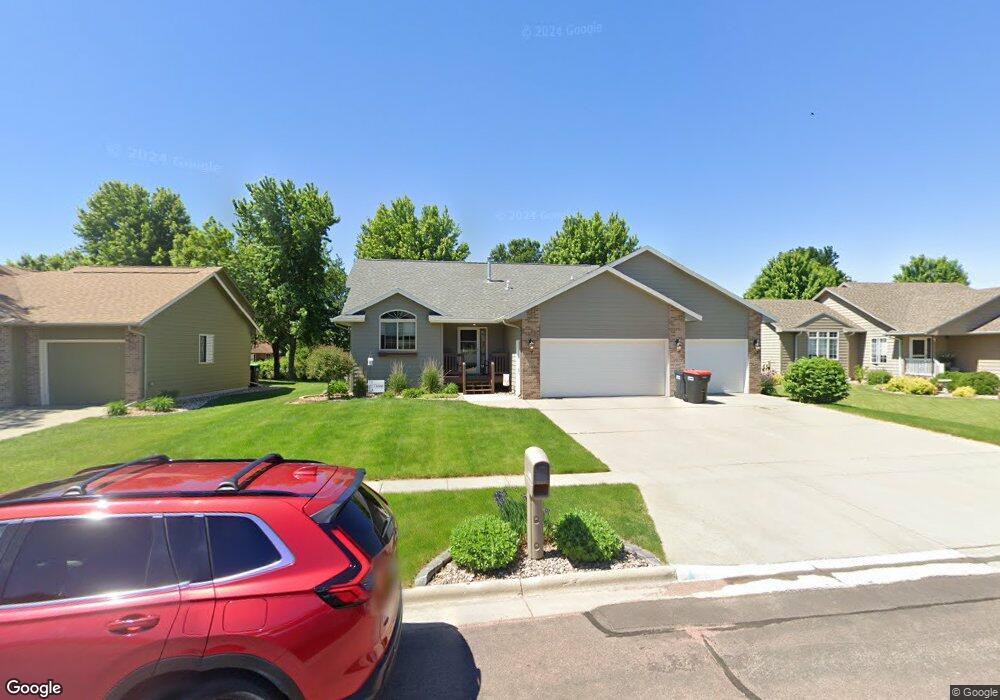
209 Tabor Ct Brandon, SD 57005
Estimated Value: $468,764 - $514,000
5
Beds
3
Baths
1,370
Sq Ft
$357/Sq Ft
Est. Value
About This Home
This home is located at 209 Tabor Ct, Brandon, SD 57005 and is currently estimated at $488,691, approximately $356 per square foot. 209 Tabor Ct is a home located in Minnehaha County with nearby schools including Brandon Elementary School, Brandon Valley Middle School, and Brandon Valley Intermediate School.
Ownership History
Date
Name
Owned For
Owner Type
Purchase Details
Closed on
Dec 4, 2023
Sold by
Aamlid Brian Nikolas and Aamlid Stacie L
Bought by
Webster Daniel Lee and Webster Stephanie Rae
Current Estimated Value
Home Financials for this Owner
Home Financials are based on the most recent Mortgage that was taken out on this home.
Original Mortgage
$375,000
Outstanding Balance
$369,079
Interest Rate
7.76%
Estimated Equity
$119,612
Purchase Details
Closed on
Sep 15, 2014
Sold by
Gregory J Gregory J and Anderson Alyssa B
Bought by
Nikolas Brian and Aamlid Stacie L
Home Financials for this Owner
Home Financials are based on the most recent Mortgage that was taken out on this home.
Original Mortgage
$204,200
Interest Rate
4.15%
Mortgage Type
New Conventional
Create a Home Valuation Report for This Property
The Home Valuation Report is an in-depth analysis detailing your home's value as well as a comparison with similar homes in the area
Home Values in the Area
Average Home Value in this Area
Purchase History
| Date | Buyer | Sale Price | Title Company |
|---|---|---|---|
| Webster Daniel Lee | $445,000 | Stewart Title Co | |
| Webster Daniel Lee | $445,000 | Stewart Title Co | |
| Nikolas Brian | $244,500 | -- |
Source: Public Records
Mortgage History
| Date | Status | Borrower | Loan Amount |
|---|---|---|---|
| Open | Webster Daniel Lee | $375,000 | |
| Closed | Webster Daniel Lee | $375,000 | |
| Previous Owner | Nikolas Brian | $204,200 |
Source: Public Records
Tax History
| Year | Tax Paid | Tax Assessment Tax Assessment Total Assessment is a certain percentage of the fair market value that is determined by local assessors to be the total taxable value of land and additions on the property. | Land | Improvement |
|---|---|---|---|---|
| 2024 | $5,555 | $416,600 | $40,500 | $376,100 |
| 2023 | $5,648 | $402,500 | $31,400 | $371,100 |
| 2022 | $5,206 | $350,500 | $31,400 | $319,100 |
| 2021 | $4,916 | $306,200 | $0 | $0 |
| 2020 | $4,916 | $309,000 | $0 | $0 |
| 2019 | $4,503 | $276,575 | $0 | $0 |
| 2018 | $4,142 | $262,562 | $0 | $0 |
| 2017 | $4,148 | $252,468 | $30,400 | $222,068 |
| 2016 | $4,148 | $248,430 | $30,400 | $218,030 |
| 2015 | $4,155 | $238,455 | $28,500 | $209,955 |
| 2014 | -- | $226,362 | $28,500 | $197,862 |
Source: Public Records
Map
Nearby Homes
- 216 Tabor Ct
- 108 Thad St
- 412 Meadowlark Cir
- 1216 W Rivulet St St
- 1212 W Rivulet St St
- 109 S Peaceful Ave Ave
- 404 N Sioux Blvd
- 408 N Sioux Blvd
- 412 N Sioux Blvd
- 300 S 1st Ave
- 505 Pasque Flower Trail
- 312 S 1st Ave
- 412 E Cairos Place
- 416 E Cairos Place
- 705 Sapphire Cir
- 901 Pine St
- 705 Ruby Cir
- 801 Ruby Cir
- 704 Ruby Cir
- 800 Ruby Cir
Your Personal Tour Guide
Ask me questions while you tour the home.