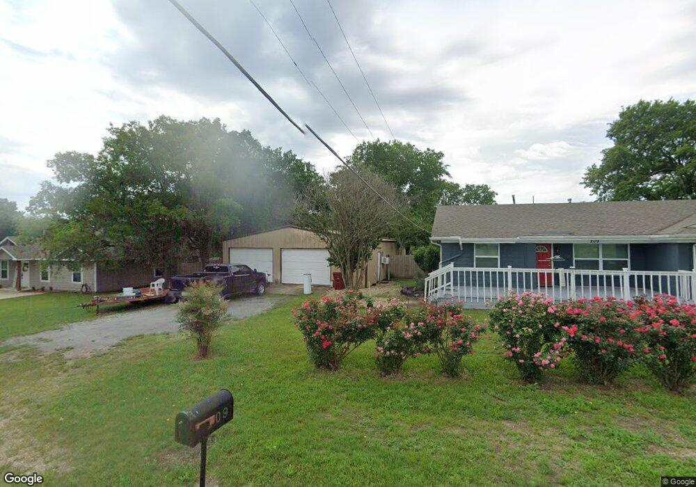
209 W Cedar St Unit B Whitewright, TX 75491
Estimated Value: $272,626 - $360,000
3
Beds
3
Baths
1,713
Sq Ft
$185/Sq Ft
Est. Value
About This Home
This home is located at 209 W Cedar St Unit B, Whitewright, TX 75491 and is currently estimated at $316,313, approximately $184 per square foot. 209 W Cedar St Unit B is a home located in Grayson County with nearby schools including Whitewright Elementary School, Whitewright Middle School, and Whitewright High School.
Ownership History
Date
Name
Owned For
Owner Type
Purchase Details
Closed on
Feb 13, 2026
Sold by
Hoffman Sandy Schaferling and James C Schaferling Revocable Living Tru
Bought by
Chetham Margie and Hoffman Sandy Schaferling
Current Estimated Value
Purchase Details
Closed on
May 19, 2021
Sold by
Smith William A
Bought by
Hoffman Sandy Schaferling and Schaferling James C
Purchase Details
Closed on
Nov 9, 2016
Sold by
Lewis John
Bought by
Smith William A
Home Financials for this Owner
Home Financials are based on the most recent Mortgage that was taken out on this home.
Original Mortgage
$97,750
Interest Rate
3.42%
Mortgage Type
Commercial
Purchase Details
Closed on
Sep 15, 2004
Sold by
Worsham Doyce and Worsham Robbie
Bought by
Lewis John
Home Financials for this Owner
Home Financials are based on the most recent Mortgage that was taken out on this home.
Original Mortgage
$56,000
Interest Rate
5.95%
Mortgage Type
Purchase Money Mortgage
Create a Home Valuation Report for This Property
The Home Valuation Report is an in-depth analysis detailing your home's value as well as a comparison with similar homes in the area
Home Values in the Area
Average Home Value in this Area
Purchase History
| Date | Buyer | Sale Price | Title Company |
|---|---|---|---|
| Chetham Margie | -- | None Listed On Document | |
| Hoffman Sandy Schaferling | -- | First American Title | |
| Smith William A | -- | Chapin Title Co Inc | |
| Lewis John | -- | -- |
Source: Public Records
Mortgage History
| Date | Status | Borrower | Loan Amount |
|---|---|---|---|
| Previous Owner | Smith William A | $97,750 | |
| Previous Owner | Lewis John | $56,000 |
Source: Public Records
Tax History
| Year | Tax Paid | Tax Assessment Tax Assessment Total Assessment is a certain percentage of the fair market value that is determined by local assessors to be the total taxable value of land and additions on the property. | Land | Improvement |
|---|---|---|---|---|
| 2025 | $2,339 | $307,148 | $71,813 | $235,335 |
| 2024 | $6,085 | $321,030 | $0 | $0 |
| 2023 | $2,276 | $288,514 | $0 | $0 |
| 2022 | $5,593 | $262,285 | $45,000 | $217,285 |
| 2021 | $4,523 | $194,613 | $30,188 | $164,425 |
| 2020 | $4,573 | $184,037 | $17,813 | $166,224 |
| 2019 | $3,591 | $139,077 | $14,438 | $124,639 |
| 2018 | $3,486 | $131,396 | $14,813 | $116,583 |
| 2017 | $2,770 | $112,868 | $14,813 | $98,055 |
| 2016 | $2,522 | $102,752 | $10,916 | $91,836 |
| 2015 | $1,760 | $75,268 | $10,444 | $64,824 |
| 2014 | $395 | $49,160 | $10,444 | $38,716 |
Source: Public Records
Map
Nearby Homes
- 404 N Blanton
- 402 E Elm St
- 404 W Elm St
- 114 E Cedar St
- 411 W Elm St
- 503 W Locust St
- 999 Eastline Rd
- 415 W Walnut St
- 507 W Locust St
- 331 W Grand St
- 410 E Locust St
- 408 E Locust St
- 406 E Locust St
- 412 E Locust St
- 414 E Locust St
- 807 Bois d Arc St
- 800 Blk Bois d Arc St
- 504 E Walnut St
- 602 1/2 W Grand St
- 401 W Maple St
Your Personal Tour Guide
Ask me questions while you tour the home.