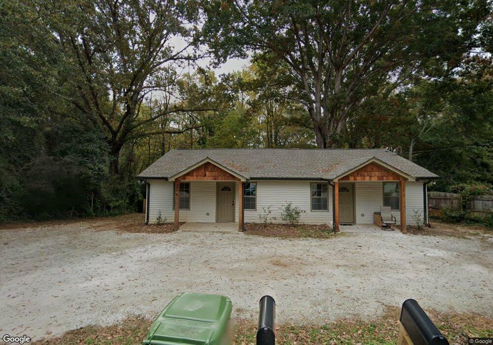
209 Walker Dr Unit B Monroe, GA 30655
Estimated Value: $211,200 - $377,000
2
Beds
1
Bath
--
Sq Ft
20,038
Sq Ft Lot
About This Home
This home is located at 209 Walker Dr Unit B, Monroe, GA 30655 and is currently estimated at $293,300. 209 Walker Dr Unit B is a home located in Walton County with nearby schools including Atha Road Elementary School, Youth Middle School, and Walnut Grove High School.
Ownership History
Date
Name
Owned For
Owner Type
Purchase Details
Closed on
May 30, 2019
Sold by
Lincoln Homes Forsyth Llc
Bought by
Ky High Investments Inc
Current Estimated Value
Purchase Details
Closed on
Oct 7, 2003
Sold by
Natl Bk Of Walton Cnty
Bought by
Coan Michael
Purchase Details
Closed on
Aug 13, 1999
Sold by
Clark Peggy B
Bought by
Sims Billy L
Home Financials for this Owner
Home Financials are based on the most recent Mortgage that was taken out on this home.
Original Mortgage
$35,200
Interest Rate
7.7%
Mortgage Type
New Conventional
Purchase Details
Closed on
Mar 31, 1988
Bought by
Clark Peggy B
Create a Home Valuation Report for This Property
The Home Valuation Report is an in-depth analysis detailing your home's value as well as a comparison with similar homes in the area
Home Values in the Area
Average Home Value in this Area
Purchase History
| Date | Buyer | Sale Price | Title Company |
|---|---|---|---|
| Ky High Investments Inc | $34,000 | -- | |
| Patriot Home Buyers Llc | $30,000 | -- | |
| Coan Michael | $35,001 | -- | |
| Sims Billy L | $44,000 | -- | |
| Clark Peggy B | $29,000 | -- |
Source: Public Records
Mortgage History
| Date | Status | Borrower | Loan Amount |
|---|---|---|---|
| Previous Owner | Sims Billy L | $35,200 |
Source: Public Records
Tax History
| Year | Tax Paid | Tax Assessment Tax Assessment Total Assessment is a certain percentage of the fair market value that is determined by local assessors to be the total taxable value of land and additions on the property. | Land | Improvement |
|---|---|---|---|---|
| 2025 | $4,006 | $113,880 | $14,520 | $99,360 |
| 2024 | $2,587 | $76,000 | $10,780 | $65,220 |
| 2023 | $2,657 | $76,000 | $10,780 | $65,220 |
| 2022 | $2,838 | $76,000 | $10,780 | $65,220 |
| 2021 | $629 | $16,280 | $6,400 | $9,880 |
| 2020 | $514 | $12,960 | $4,800 | $8,160 |
| 2019 | $445 | $10,280 | $4,000 | $6,280 |
| 2018 | $405 | $10,280 | $4,000 | $6,280 |
| 2017 | $362 | $8,640 | $3,400 | $5,240 |
| 2016 | $331 | $8,040 | $3,400 | $4,640 |
| 2015 | $309 | $7,360 | $3,400 | $3,960 |
| 2014 | $318 | $7,360 | $3,400 | $3,960 |
Source: Public Records
Map
Nearby Homes
- 212 Walker Dr
- 206 Walker Dr
- 1435 Creek View Dr
- 223 Atha St
- 227 Atha St
- 1230 S Madison Ave
- 429 Red Oak Ct
- 1037 S Madison Ave
- 808 S Broad St
- 1328 S Madison Ave
- 404 Walker Dr
- 529 Mill Farm Ln
- 525 Mill Farm Ln
- 500 Mill Farm Ln
- 416 Shamrock Dr
- 339 Flat Creek Dr
- 1004 Stone Creek Ln
- 739 Wheel House Ln Unit B
- 739 Wheel House Ln Unit A
- 736 Wheel House Ln Unit B
Your Personal Tour Guide
Ask me questions while you tour the home.