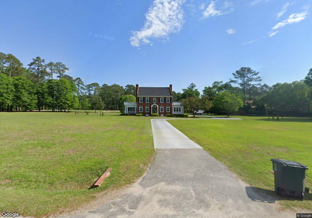
209 Wyandot St Darlington, SC 29532
Estimated Value: $362,000 - $463,000
3
Beds
4
Baths
2,108
Sq Ft
$199/Sq Ft
Est. Value
About This Home
This home is located at 209 Wyandot St, Darlington, SC 29532 and is currently estimated at $419,760, approximately $199 per square foot. 209 Wyandot St is a home located in Darlington County with nearby schools including J.L. Cain Elementary School, J. L. Cain Elementary, and Brunson-Dargan Elementary School.
Ownership History
Date
Name
Owned For
Owner Type
Purchase Details
Closed on
Sep 21, 2022
Sold by
Lane Clifford D
Bought by
Roberts Bryan Sharpe and Roberts Deborah Angela
Current Estimated Value
Home Financials for this Owner
Home Financials are based on the most recent Mortgage that was taken out on this home.
Original Mortgage
$350,000
Outstanding Balance
$335,172
Interest Rate
5.55%
Mortgage Type
Balloon
Estimated Equity
$84,588
Purchase Details
Closed on
May 12, 2021
Sold by
Lane Robin T
Bought by
Lane Clifford D and Lane Robin D
Create a Home Valuation Report for This Property
The Home Valuation Report is an in-depth analysis detailing your home's value as well as a comparison with similar homes in the area
Home Values in the Area
Average Home Value in this Area
Purchase History
| Date | Buyer | Sale Price | Title Company |
|---|---|---|---|
| Roberts Bryan Sharpe | $400,000 | -- | |
| Lane Clifford D | $72,430 | None Available |
Source: Public Records
Mortgage History
| Date | Status | Borrower | Loan Amount |
|---|---|---|---|
| Open | Roberts Bryan Sharpe | $350,000 |
Source: Public Records
Tax History Compared to Growth
Tax History
| Year | Tax Paid | Tax Assessment Tax Assessment Total Assessment is a certain percentage of the fair market value that is determined by local assessors to be the total taxable value of land and additions on the property. | Land | Improvement |
|---|---|---|---|---|
| 2024 | $2,752 | $16,000 | $2,400 | $13,600 |
| 2023 | $4,000 | $16,000 | $2,400 | $13,600 |
| 2022 | $3,624 | $16,000 | $2,400 | $13,600 |
| 2021 | $3,624 | $14,500 | $2,400 | $12,100 |
| 2020 | $2,077 | $14,500 | $2,400 | $12,100 |
| 2019 | $2,141 | $14,500 | $2,400 | $12,100 |
| 2018 | $1,733 | $13,600 | $2,400 | $11,200 |
| 2017 | $1,567 | $13,600 | $2,400 | $11,200 |
| 2016 | $1,522 | $13,600 | $2,400 | $11,200 |
| 2014 | $1,636 | $13,600 | $2,400 | $11,200 |
| 2013 | $1,661 | $12,890 | $4,000 | $8,890 |
Source: Public Records
Map
Nearby Homes
- 303 Wyandot St
- 108 Wyandot St
- 213 Green Dr
- TBD Green Dr
- 13 Tee Cir
- 14 Tee Cir
- 9 Country Club Rd
- 54 Country Club Rd
- 56 Country Club Rd
- 58 Country Club Rd
- 55 Country Club Rd
- 57 Country Club Rd
- 59 Country Club Rd
- 601 Cashua Ferry Rd
- 103 Fulton Rd
- 106 Lincoln Blvd
- 111 Brittain Rd
- 411 Joe Louis Blvd
- 416 S Warley St
- 128 Spring Heights Cir
- 301 Wyandot St
- 198 Wyandot St
- 126 Wyandot St
- 204 Wyandot St
- 202 Wyandot St
- 206 Wyandot St
- 102 Iroquois St
- 208 Wyandot St
- 125 Wyandot St
- 305 Wyandot St
- 103 Iroquois St
- 304 Wyandot St
- 124 Wyandot St
- 307 Wyandot St
- 121 Wyandot St
- 122 Wyandot St
- 306 Wyandot St
- 317 Wyandot St
- 113 Nez Perce Dr
- 309 Wyandot St